MyTopo
Clintondale New York US Topo Map
Couldn't load pickup availability
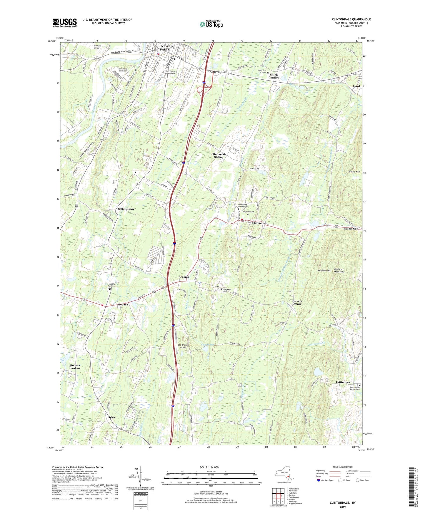
2023 topographic map quadrangle Clintondale in the state of New York. Scale: 1:24000. Based on the newly updated USGS 7.5' US Topo map series, this map is in the following counties: Ulster. The map contains contour data, water features, and other items you are used to seeing on USGS maps, but also has updated roads and other features. This is the next generation of topographic maps. Printed on high-quality waterproof paper with UV fade-resistant inks.
Quads adjacent to this one:
West: Gardiner
Northwest: Mohonk Lake
North: Rosendale
Northeast: Hyde Park
East: Poughkeepsie
Southeast: Wappingers Falls
South: Newburgh
Southwest: Walden
This map covers the same area as the classic USGS quad with code o41074f1.
Contains the following named places: Adair Vineyards, Aloha Home Acres Mobile Home Park, Alumni Soccer Field, Apple Greens Golf Course, Apple Hill Farm, Ardonia, Athletic And Wellness Center, Baileys Gap, Bevier Hall, Bliss Hall, Bouton Hall, Camp Sunset, Capen Hall, Center For International Programs, Charles Cook Children's Center, Church of Jesus Christ of Latter Day Saints, Clintondale, Clintondale Census Designated Place, Clintondale Friends Cemetery, Clintondale Post Office, Clintondale School, Clintondale Station, Clintondale Volunteer Fire Department Allied Communities Fire Company 1, College Hall, Congregation Ahavath Achim, Coykendall Science Building, Crispell Hall, Dembroski Orchards, Depew Mobile Home Park, Deyo Hall, Dressel Farms, DuBois Hall, DuBois Landing Field, East Plattekill Cemetery, Elting Corners, Elting Gymnasium, Elting Memorial Library, Esopus Hall, Faculty Office Building, Fine Arts Building, Fox Run Estates Mobile Home Park, Gage Hall, Haggerty Administration Building, Haggerty Plaza, Hanmer House, Hasbrouck Dining Hall, Hideaway Mobile Home Park, Highland High School, Highland Woods Mobile Home Park, Hopfer Admissions And Alumni Center, Humanities Classroom Building, Jacobson Faculty Tower, Jenkinstown, Lake Sunset, Lattingtown Baptist Cemetery, Lattingtown Baptist Church, Lattintown, LeFevre Hall, Lenape Elementary School, Lenape Hall, Lloyd, Loren Campbell Baseball Field, Maria's Garden Montessori School, Marlboro Airport, Marlboro Mountain, Marlboro Mountains, Marlborough School, McKenna Theatre, Minard Farms, Minard Farms Airport, Modena, Modena Fire Department, Modena Gardens, Modena Post Office, Modena Rural Cemetery, Modena School, Mountain Laurel Waldorf School, New Paltz, New Paltz Fire Department Station 1, New Paltz High School, New Paltz Middle School, New Paltz Nursing Home, New Paltz Post Office, New Paltz Rural Cemetery, New Paltz Toll Plaza, New Paltz United Methodist Church, Ohioville, Ohioville School, Old Main, Old Orchard Airpark, Pancake Hollow Brook, Parker Theatre, Plattekill Library, Plattekill School, Putt Corners, Redeemer Lutheran Church, Relyea Ground, Resnick Engineering Hall, Saint Andrew's Episcopal Church, Saint Joseph's Hall, Saint Joseph's Parochial School, Saint Joseph's Roman Catholic Church, Samuel Dorsky Museum of Art, Scudder Hall, Shango Hall, Smiley Art Building, Sojourner Truth Library, South Classroom Building, State University of New York at New Paltz, Student Union Building, Sylva, The Terrace, Town of Plattekill, Triboro School, Trout Brook Mobile Home Park, Tuckers Corner, Union Cemetery of Lloyd, Van Den Berg Hall, Van Den Berg Hall Annex, Village of New Paltz, Wallkill View Farm, Wilklow Orchards, Wooster Science Building, WRWD-FM (Highland), WVKR-FM (Poughkeepsie), ZIP Codes: 12515, 12528, 12548