MyTopo
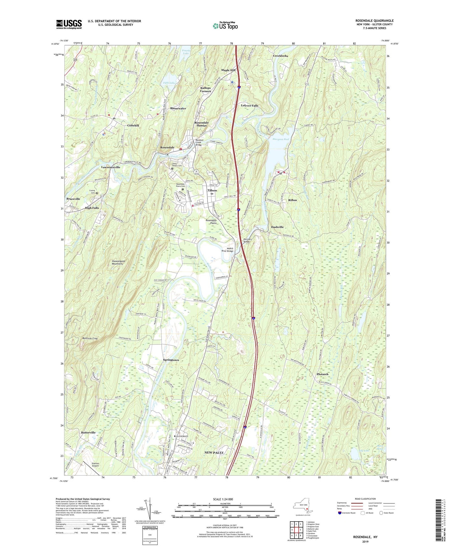
Rosendale New York US Topo Map
Couldn't load pickup availability
2023 topographic map quadrangle Rosendale in the state of New York. Scale: 1:24000. Based on the newly updated USGS 7.5' US Topo map series, this map is in the following counties: Ulster. The map contains contour data, water features, and other items you are used to seeing on USGS maps, but also has updated roads and other features. This is the next generation of topographic maps. Printed on high-quality waterproof paper with UV fade-resistant inks.
Quads adjacent to this one:
West: Mohonk Lake
Northwest: Ashokan
North: Kingston West
Northeast: Kingston East
East: Hyde Park
Southeast: Poughkeepsie
South: Clintondale
Southwest: Gardiner
This map covers the same area as the classic USGS quad with code o41074g1.
Contains the following named places: All Saints Church, Anna Devine School, Bergemanns Farm, Binnewater, Bloomington Volunteer Fire Department Binnewater Station, Boces School, Bonticou Crag, Brookside School, Bruceville, Butterville, Camp Dineen, Chapel of Boy Jesus, Cottekill, Cottekill Brook, Cottekill Post Office, Cottekill Volunteer Fire Company, Coxing Cemetery, Coxing Kill, Creeklocks, Creeklocks School, Culinarian's Home Assisted Living Facility, Dashville, District School Number 5, Duzine Elementary School, Esppus District School Number 6, Fifth Lake, Friends Church, Greger Farm, High Falls Census Designated Place, Huguenot Historical Library, Huguenot Street Historic District, Kallops Corners, Kingdom Hall Church, Kingdom Hall of Jehovahs Witnesses, Kleine Kill, Lawrenceville, Lefever Falls, Lily Lake, Maple Hill, Maple Hill School, Memorial House, Mollenhauer Farm, New Paltz Church of the Nazarene, New Paltz Fire Department Station 2 and Rescue Squad, New Paltz Golf Course, New Paltz Rescue Squad, New Paltz Sewage Plant, Our Lady Help of Christians Roman Catholic Church, Perrine's Bridge, Plutarch, Plutarch School, Reformed Church, Reformed Church of New Paltz, Rifton, Rifton Census Designated Place, Rifton Church, Rifton Fire District Station 1, Rifton Fire District Station 2, Rifton Post Office, Rivers Edge Cooperative Mobile Home Park, Rock School, Rondout Creek Bridge, Rosendale, Rosendale Census Designated Place, Rosendale Elementary School, Rosendale Library, Rosendale Plains, Rosendale Plains Cemetery, Rosendale Post Office, Rosendale School, Rosendale Union Free School, Rosendale Volunteer Fire Department Active Hose Company 1, Saint Peters Cemetery, Saint Peter's Roman Catholic Church, Saint Peter's School, Saint Remy Fire Department, Springtown, Stanton Airport, Sturgeon Pool, Swarte Kill, Tillson, Tillson Census Designated Place, Tillson Community Church, Tillson Fire District, Tillson Post Office, Tillson School, Town of New Paltz, Town of Rosendale, Twilight Acres, Twin Star Farms, Ulster County Community College, Walkill River Bridge, Wallkill River, Wallkill Valley, Washington Mobile Home Park, Woodcrest School, ZIP Codes: 12419, 12471, 12472, 12486, 12561