MyTopo
Mohonk Lake New York US Topo Map
Couldn't load pickup availability
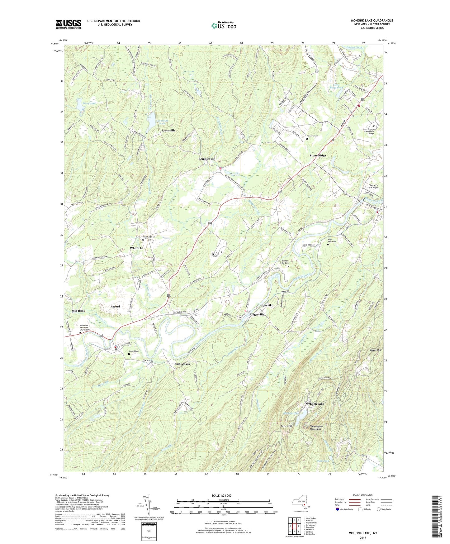
2023 topographic map quadrangle Mohonk Lake in the state of New York. Scale: 1:24000. Based on the newly updated USGS 7.5' US Topo map series, this map is in the following counties: Ulster. The map contains contour data, water features, and other items you are used to seeing on USGS maps, but also has updated roads and other features. This is the next generation of topographic maps. Printed on high-quality waterproof paper with UV fade-resistant inks.
Quads adjacent to this one:
West: Kerhonkson
Northwest: West Shokan
North: Ashokan
Northeast: Kingston West
East: Rosendale
Southeast: Clintondale
South: Gardiner
Southwest: Napanoch
This map covers the same area as the classic USGS quad with code o41074g2.
Contains the following named places: Accord, Accord Cemetery, Accord Census Designated Place, Accord Fire District Accord Volunteer Fire Company 1, Accord Fire District Alligerville Volunteer Fire Company 3, Accord Post Office, Accord Speedway, Algonquin Building, Alligerville, Alligerville Union School, Atkins Mobile Home Park, Benbyre Farm Heliport, Benton-Bar Cemetery, Bumbleburg Farm, Camp Shangri La, Christ the King Episcopal Church, Clove Chapel, Clove Reformed Church, Clove School, DiGrazia's Tree Farm, Duck Pond, Dutchess Farm, Eagle Cliff, Epworth Church, Fairview Cemetery, Feather Farm, Flying Change Farm, George Clinton Hall, Guyot Hill, Harrington Farms, High Falls, High Falls Cemetery, High Falls Community Church, High Falls Hydro Station, High Falls Post Office, High Falls Railroad Station, High Falls School, High Falls Volunteer Fire Department, High Meadow School, Jacob A Hasbrouck Hall, Jacob Hardenbergh Hall, John Burroughs Hall, John Vanderlyn Hall, Kripplebush, Kripplebush - Lyonsville Fire Company, Kripplebush Creek, Kripplebush School, Kyserike, Kyserike Railroad Station, Little Egg Farm, Longview Farm, Lyonsville, Lyonsville Pond, Lysonville School, Macdonald DeWitt Library, Marbletown Elementary School, Marbletown Reformed Church, Marbletown Town Hall, Marshall's Tree Farm, Mill Hook, Mohonk House, Mohonk Lake, Mohonk View Farm, Mombaccus Creek, Moosy Brook, Morning Garden Farm, New Paltz Water Plant, North Peters Kill, Oak Grove School, Peak School, Peters Kill, Rochester Creek, Rochester Reformed Church, Rochester Reformed Church Cemetery, Rochester School, Rock Hill School, Rondout Country Club, Rondout Valley High School, Rondout Valley Middle School, Roosa Lake, Saint Josen, Saint Marys Convent, Saint Peters Church, Sanders Kill, Saunderskill Farms, Senate Gymnasium, Sheeley's Farm Airport, So Hi Campground, Standing Rock Farm, Stone Dock Golf Course, Stone Ridge, Stone Ridge Census Designated Place, Stone Ridge Orchard, Stone Ridge Pond, Stone Ridge Post Office, Stone Ridge Public Library, Stone Ridge School, Stone Ridge Volunteer Fire Company, Stony Kill, Stover's Christmas Tree Farm, Town of Marbletown, Westwind Organic Orchard, Whitfield, Whitfield Cemetery, Whitfield School, ZIP Codes: 12404, 12440, 12484