MyTopo
Concord North Carolina US Topo Map
Couldn't load pickup availability
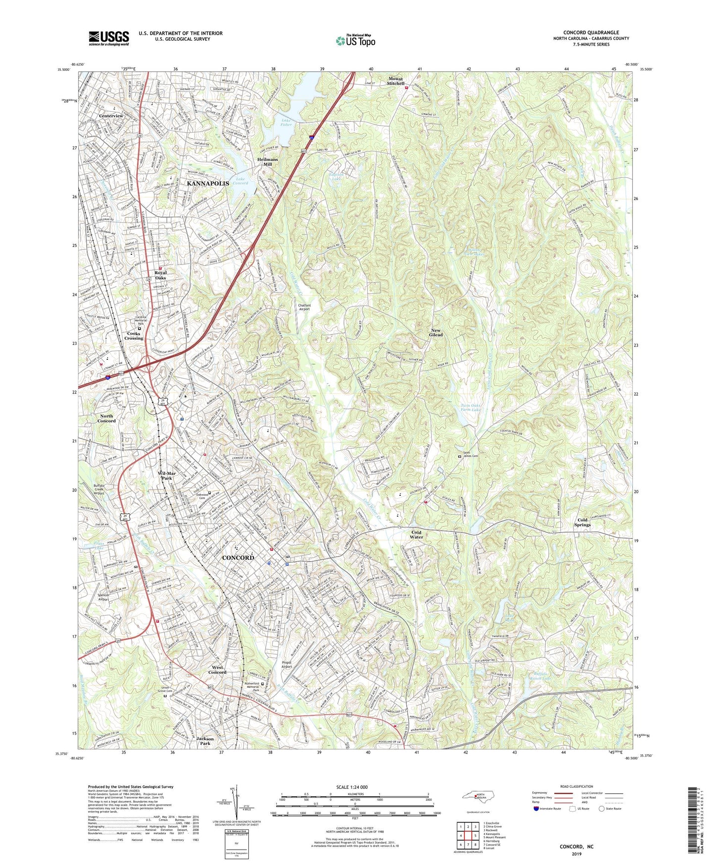
2022 topographic map quadrangle Concord in the state of North Carolina. Scale: 1:24000. Based on the newly updated USGS 7.5' US Topo map series, this map is in the following counties: Cabarrus. The map contains contour data, water features, and other items you are used to seeing on USGS maps, but also has updated roads and other features. This is the next generation of topographic maps. Printed on high-quality waterproof paper with UV fade-resistant inks.
Quads adjacent to this one:
West: Kannapolis
Northwest: Enochville
North: China Grove
Northeast: Rockwell
East: Mount Pleasant
Southeast: Locust
South: Concord SE
Southwest: Harrisburg
This map covers the same area as the classic USGS quad with code o35080d5.
Contains the following named places: 601 Industrial Park, Barber-Scotia College, Bell Mission School, Bells Chapel Church, Bethel Church, Bethlehem Church, Beverly Hills Neighborhood Park, Beverly Hills School, Bright Light Church, Brookdale Church, Brown School, Buffalo Creek Airport, Buffalo Ranch Lake, Buffalo Ranch Lake Dam, Cabarrus Academy, Cabarrus Country Club, Cabarrus County, Cabarrus County Emergency Medical Services Station 1, Cabarrus County Hospital, Cabarrus County Nursing Home, Cabarrus County Sheriff's Office, Cabarrus Rescue Squad, Caldwell Community Park, Cannon Junior High School, Carolina Mall, Carolina Memorial Park, Carolinas HealthCare System Northeast, Carver School, Cedar Grove Church, Center Church, Centerview, Centerview School, Chalfant Airport, Cloverleaf Shopping Center, Cold Springs, Cold Water, Cold Water Church, Coldwater Volunteer Fire Department, Colemans, Coltrane - Webb Stem Elementary School, Concord, Concord Business Park, Concord City Police Department, Concord Fire and Life Safety Station 1, Concord Fire and Life Safety Station 2, Concord Fire and Life Safety Station 3 Headquarters, Concord Fire and Life Safety Station 4, Concord Nursing Center, Concord Parkade Shopping Center, Concord Parkway Post Office, Concord Plaza Shopping Center, Concord Post Office, Cooks Crossing, Drye School, East Bethel Church, East Side Church, Echo Park, Edgison Lake, Epworth Church, Flow Harris Church, Fryes Lake, Funderburks Lake, Harris School, Hartsell School, Heilmans Mill, Hillgrove Filtration Park, Jackson Park, Kannapolis, Kannapolis Fire Department Station 3, Kannapolis Fire Department Station 4, Keller Church, Kelly Church, Lake Concord, Lake Concord Dam, Lake Fisher, Lake Fisher Dam, Lake Lynn, Lake Lynn Dam, Les Myers Community Park, Liberty Church, Lick Branch, Little Cold Water Creek, Logan School, McAllister School, Mount Calvary Church, Mount Mitchell, Mount Mitchell Volunteer Fire Department, Mount Olivet Church, Near the Cross Church, New Gilead, New Hope Church, New Testament Missionary Church, North Concord, Oakwood Cemetery, Parkwood Church, Penn Avenue Church, Propst Airport, Royal Oaks, Royal Oaks School, Royal Pearl Quarry, Rutherford Memorial Park, Saint James Cemetery, Saint James Church, Saint Peters Church, Shankletown School, Sharon Church, Shopshire Dam, Shopshire Re Lake, Silver Hill Church, Skyland Church, Sossamon Industrial Park, Spencer Airport, Threemile Branch, Township 12-Concord, Township 5-New Gilead, Twin Oaks Farm Lake, Twin Oaks Farm Lake Dam, Water of Life Fellowship Associate Reformed Presbyterian Church, WEGO-AM (Concord), West Concord, West Concord Cemetery, WGTL-AM (Kannapolis), Willow View Lakes, Wil-Mar Park, Winecoff School, WJZR-FM (Kannapolis), WPEG-FM (Concord), WRKB-AM (Kannapolis), ZIP Codes: 28025, 28083