MyTopo
Currie North Carolina US Topo Map
Couldn't load pickup availability
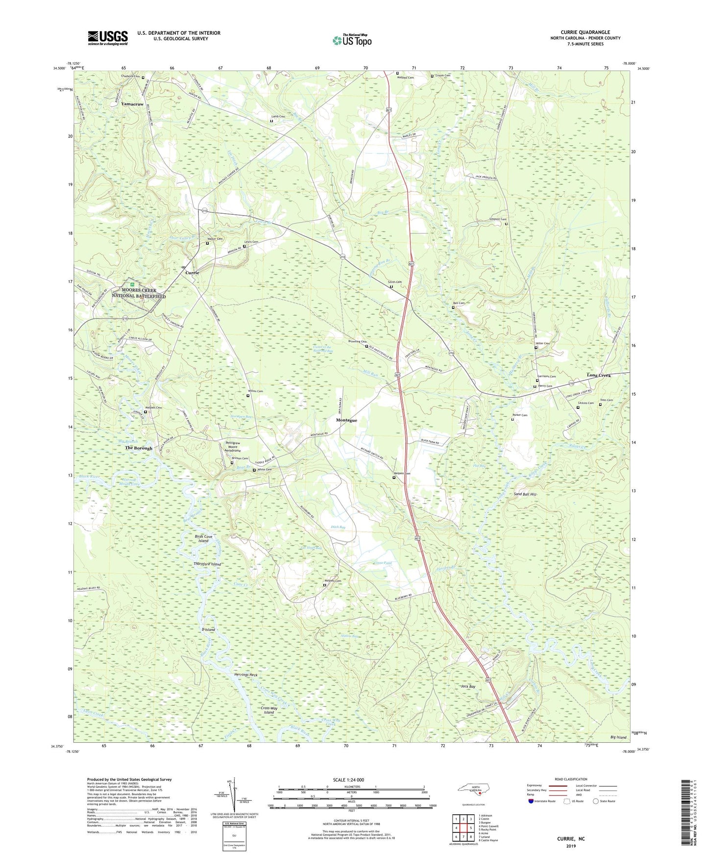
2019 topographic map quadrangle Currie in the state of North Carolina. Scale: 1:24000. Based on the newly updated USGS 7.5' US Topo map series, this map is in the following counties: Pender. The map contains contour data, water features, and other items you are used to seeing on USGS maps, but also has updated roads and other features. This is the next generation of topographic maps. Printed on high-quality waterproof paper with UV fade-resistant inks.
Quads adjacent to this one:
West: Point Caswell
Northwest: Atkinson
North: Costin
Northeast: Burgaw
East: Rocky Point
Southeast: Castle Hayne
South: Leland
Southwest: Acme
Contains the following named places: Bear Branch, Bear Branch Church, Bell Cemetery, Big Branch, Birds Cove Island, Black Swamp, Brinson Cemetery, Browning Cemetery, Buckle Swamp Creek, Burnt Landing, Cane Creek, Chadwick Cemetery, Collins Branch, Croom Cemetery, Cross Way Creek, Cross Way Island, Cunning Bluff Landing, Currie, Currie Post Office, Currie School, Curve of the Railroad Bay, Cypress Grove Mobile Home Park, D Island, Deer Valley Branch, Dick Taylor Landing, Ditch Bay, Ditch Landing, E and H Mobile Home Park, Flat Bay, Garrisons Cemetery, Goose Pond, Grady Monument park, Guffords Branch, Hedden Bluff Landing, Henry Cemetery, Herrings Neck, History Trail, Horsepen Bay, Isom Cemetery, Jack Bay, Jumping Run Branch, Juniper Branch, Lamb Cemetery, Larkins Cemetery, Lee Ditch, Lee Hugh Bay, Lewis Branch, Lewis Cemetery, Long Creek, Long Creek Census Designated Place, Long Creek Grady School, Loyalist Monument, Malpass Cemetery, Mill Branch, Mill Creek, Mill Run, Miller Cemetery, Montague, Moore Monument, Moores Creek, Moores Creek Church, Moores Creek National Battlefield, Mulberry Branch, Myrtle Grove Church, Narrow Mouth Cove, Parker Cemetery, Patriots Hall, Pettigrew Moore Aerodrome, Rileys Creek, Saint James Church, Saint John Church, Sand Ball Hill, Simpson Cemetery, Slocumb Monument, Smith Cemetery, Stage Road Monument, Station Bay, Sykes Landing, Tarheel Trail, The Borough, Thorofare, Thorofare Island, Township of Grady, Township School, Walker Cemetery, White Cemetery, Wilton Cemetery, WKNZ Tower, Yamacraw, ZIP Code: 28435