
MyTopo
Dellwood North Carolina US Topo Map
Couldn't load pickup availability
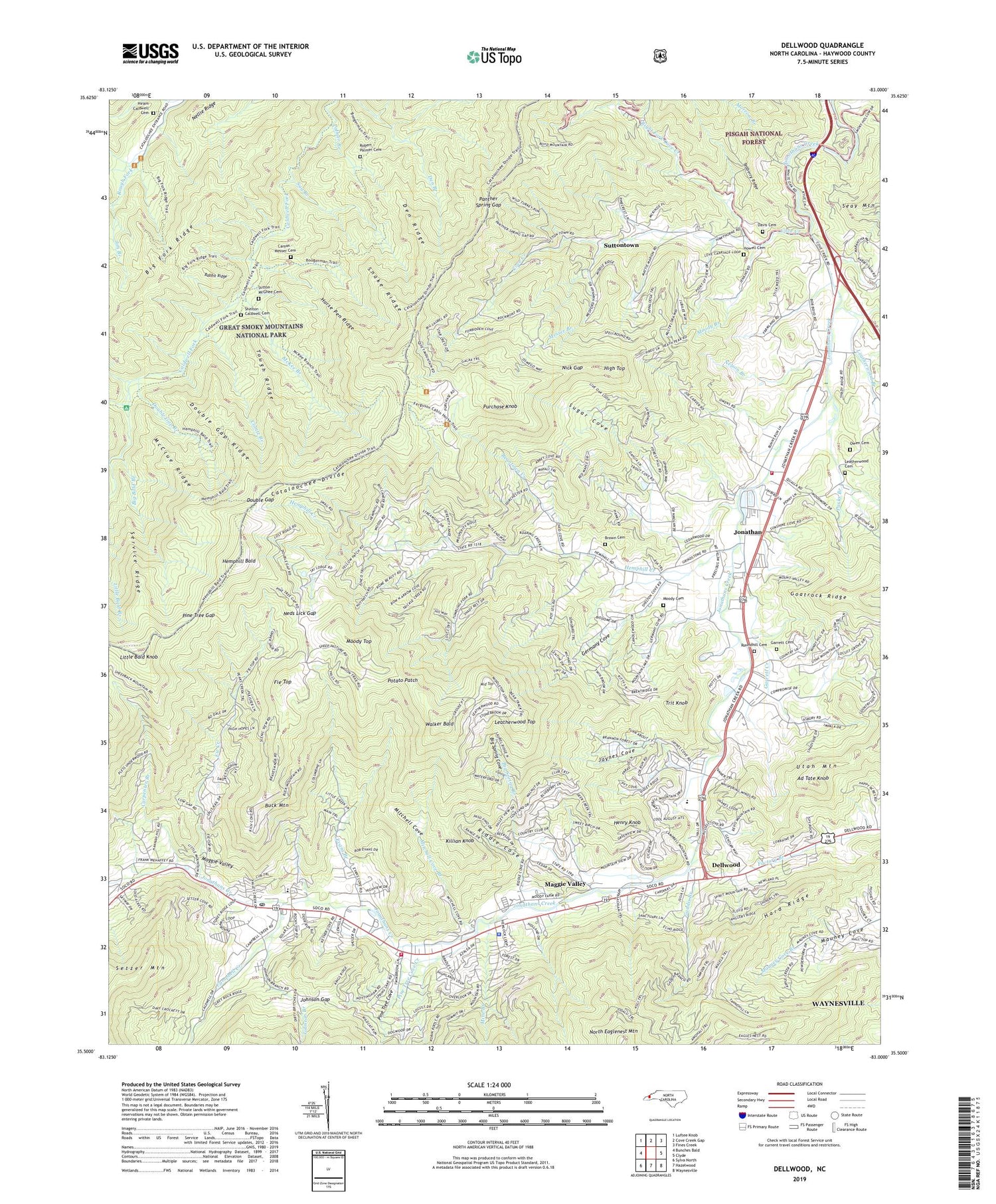
2019 topographic map quadrangle Dellwood in the state of North Carolina. Scale: 1:24000. Based on the newly updated USGS 7.5' US Topo map series, this map is in the following counties: Haywood. The map contains contour data, water features, and other items you are used to seeing on USGS maps, but also has updated roads and other features. This is the next generation of topographic maps. Printed on high-quality waterproof paper with UV fade-resistant inks.
Quads adjacent to this one:
West: Bunches Bald
Northwest: Luftee Knob
North: Cove Creek Gap
Northeast: Fines Creek
East: Clyde
Southeast: Waynesville
South: Hazelwood
Southwest: Sylva North
Contains the following named places: Ad Tate Knob, Beantown Creek, Big Bald Branch, Big Spring Branch, Big Spring Cove, Brown Cemetery, Buck Mountain, Caldwell Fork Trail, Campbell Creek, Carpenter Branch, Carson - Messer Cemetery, Cataloochee Divide, Clontz Branch, Cove Creek, Cove Creek Church, Davis Cemetery, Dellwood, Den Ridge, Double Gap, Double Gap Branch, Double Gap Ridge, Evans Branch, Fie Creek, Fie Top, Gaddis Branch, Garrett Cemetery, Garrett Creek, Germany Cove, Hard Ridge, Hemphill Bald, Hemphill Creek, Henry Knob, High Top, Hiram Caldwell Cemetery, Holiness Church, Horse Pen Ridge, Howell Cemetery, Jaynes Cove, Jim Branch, Johnson Branch, Johnson Gap, Jonathan, Jonathan Creek Volunteer Fire Department, Killian Knob, Leatherwood Branch, Leatherwood Cemetery, Leatherwood Top, Little Bald Knob, Maggie Valley, Maggie Valley Police Department, Maggie Valley Post Office, Maggie Valley Volunteer Fire Department, McClue Ridge, McKee Branch, Messer Branch, Middle Top, Mine Branch, Mitchell Cove, Mitchell Cove Branch, Moody Branch, Moody Cemetery, Moody Top, Morrow Branch, Ned Branch, Neds Lick Gap, Nellie Ridge, Nelson Branch, Nick Gap, North Eaglenest Mountain, Olivet Church, Owen Cemetery, Palmer Branch, Panther Spring Gap, Parks Branch, Pine Tree Cove, Pine Tree Cove Creek, Pine Tree Gap, Potato Patch, Purchase Knob, Rabbit Ridge, Riddle Cove, Right Fork Cove Creek, Robert Palmer Cemetery, Rock Hill School, Roundhill Cemetery, Sag Branch, Service Ridge, Shady Grove Church, Shanty Branch, Shelton - Caldwell Cemetery, Snake Branch, Snake Ridge, Straight Creek, Sugar Cove, Sutton - McGhee Cemetery, Suttontown, Tough Ridge, Town of Maggie Valley, Township of Ivy Hill, Township of Jonathan Creek, Trit Knob, Walker Bald, ZIP Code: 28751


