MyTopo
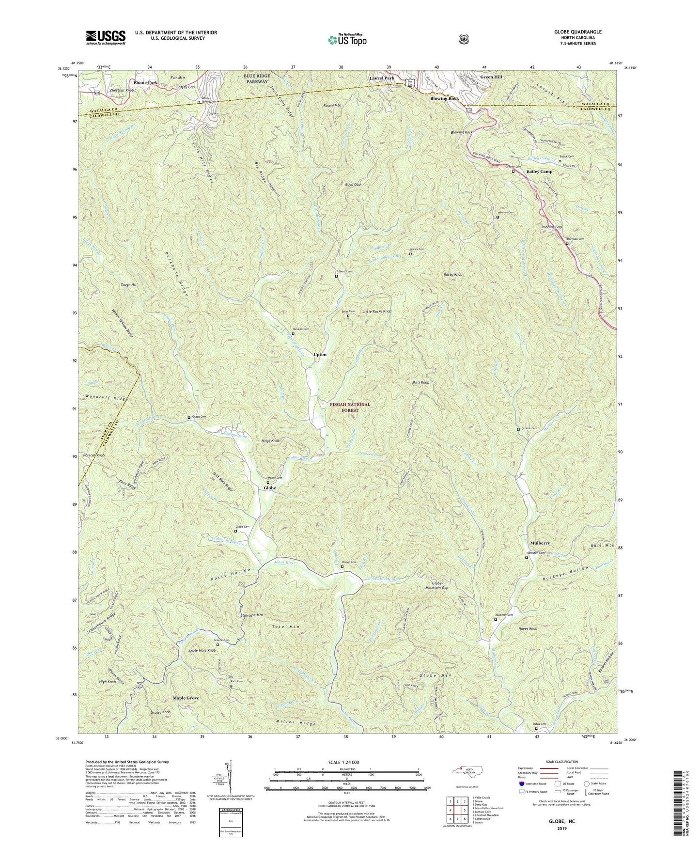
Globe North Carolina US Topo Map
Couldn't load pickup availability
2019 topographic map quadrangle Globe in the state of North Carolina. Scale: 1:24000. Based on the newly updated USGS 7.5' US Topo map series, this map is in the following counties: Caldwell, Watauga, Avery. The map contains contour data, water features, and other items you are used to seeing on USGS maps, but also has updated roads and other features. This is the next generation of topographic maps. Printed on high-quality waterproof paper with UV fade-resistant inks.
Quads adjacent to this one:
West: Grandfather Mountain
Northwest: Valle Crucis
North: Boone
Northeast: Deep Gap
East: Buffalo Cove
Southeast: Lenoir
South: Collettsville
Southwest: Chestnut Mountain
Contains the following named places: Amos Creek, Anthony Bolick Branch, Anthony Creek, Apple Hole Knob, Apple Ridge, Backbone Ridge, Bailey Camp, Bailey Camp Church, Ballew Creek, Barn Ridge, Benson Hollow, Big Branch, Big Ridge, Bills Branch, Billys Knob, Blowing Rock, Blowing Rock Estates, Blue Ridge Church, Bolick Cemetery, Boone Fork, Boone Fork School, Boones Fork Baptist Church, Boyd Gap, Buckeye Hollow, Burnfield Branch, Cane Branch, Chestnut Knob, China Creek, Clark Branch, Cline Creek, Coffey Gap, Cold Water Creek, Cooper Branch, Crooked Branch, Curtis Creek, Dixon Creek, Dyson Creek, Edmisten Cemetery, Estes Cemetery, Fair Mountain, Falcon Crest, Frankum Creek, Friddle Creek, Gay Mountain, Georges Creek, Gilbert Branch, Globe, Globe Cemetery, Globe Church, Globe Mountain, Globe Mountain Branch, Globe Mountain Gap, Gragg Cemetery, Gragg Prong, Grassy Knob, Green Hill, Greene Cemetery, Harrison Cemetery, Hayes Knob, Herman Cemetery, High Knob, Honey Branch, Johns River Camp, Johns River Church, Kelsey, Laurel Fork, Laurel Park, Left Fork Mulberry Creek, Little Rocky Knob, Locust Ridge, Long Branch, Maple Grove, Maple Grove Baptist Church, Martin Branch, McLean Cemetery, Miller Ridge, Mills Creek, Mills Knob, Moore Cemetery, Mulberry, Mulberry Baptist Church, Mulberry Campground, Mulberry Cemetery, New Years Creek, Orchard Branch, Pack Hill Ridge, Phillips Creek, Pinchgut Creek, Polecat Knob, Potts Hollow, Racket Creek, Rich Cemetery, Rightfork Mulberry Creek, Roaring Creek, Robbins Gap, Rocky Knob, Round Mountain, Rufus Baptist Church, Rufus Cemetery, Rush Branch, Schoolhouse Ridge, Shop Branch, Split Rock Ridge, Staircase Mountain, Stein Branch, Tate Mountain, The Forest at Blowing Rock, Thunderhole Creek, Tolbert Cemetery, Tough Hill, Tough Hill Branch, Township of Globe, Township of Mulberry, Upton, Walker Hollow Ridge, Walnut Bottom Creek, White Spring Branch, White Spring Cemetery, Wildcat Branch, Woodruff Branch, ZIP Code: 28611