MyTopo
Pisgah Forest North Carolina US Topo Map
Couldn't load pickup availability
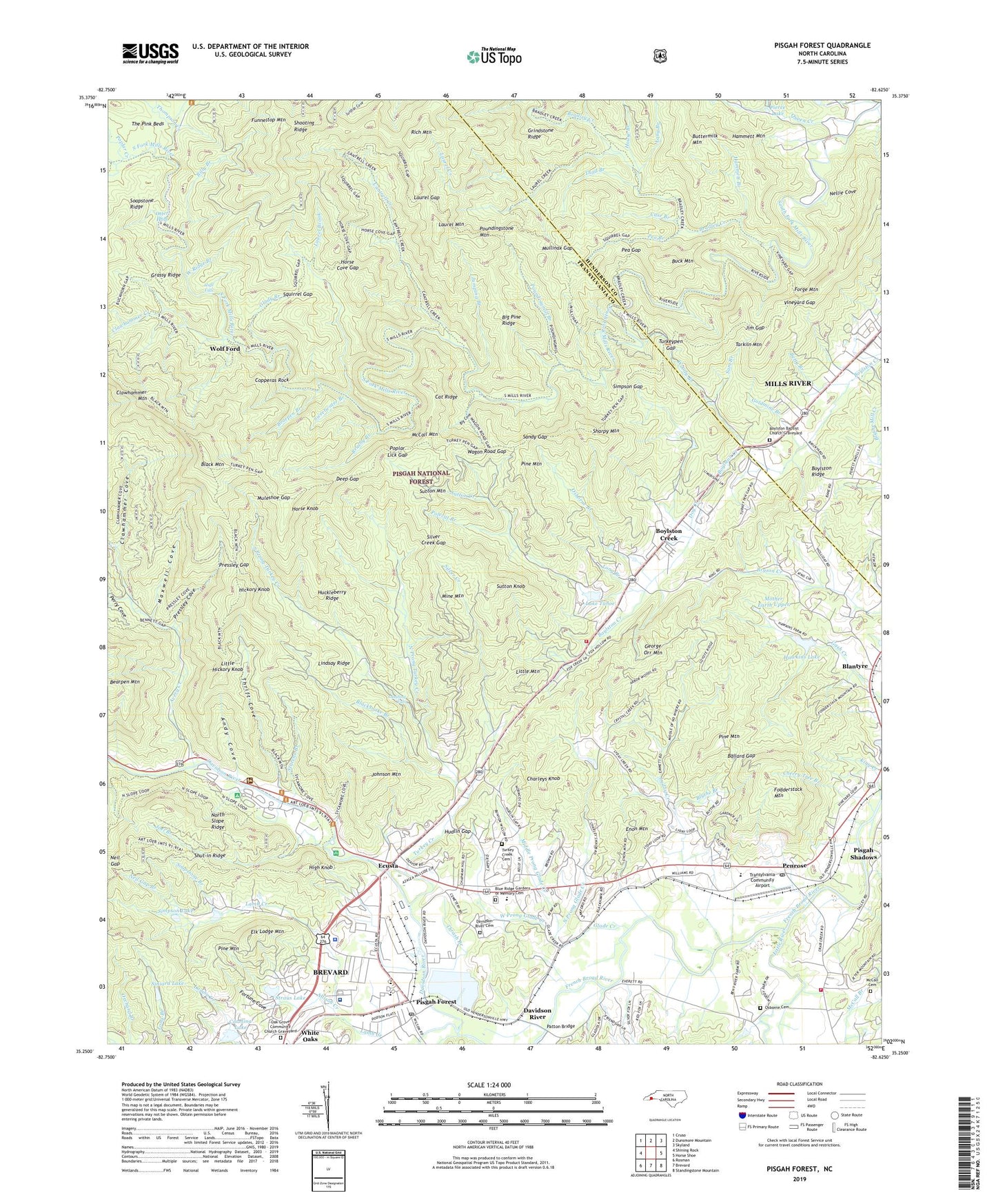
2019 topographic map quadrangle Pisgah Forest in the state of North Carolina. Scale: 1:24000. Based on the newly updated USGS 7.5' US Topo map series, this map is in the following counties: Transylvania, Henderson. The map contains contour data, water features, and other items you are used to seeing on USGS maps, but also has updated roads and other features. This is the next generation of topographic maps. Printed on high-quality waterproof paper with UV fade-resistant inks.
Quads adjacent to this one:
West: Shining Rock
Northwest: Cruso
North: Dunsmore Mountain
Northeast: Skyland
East: Horse Shoe
South: Brevard
Southwest: Rosman
Contains the following named places: Allison Creek, Andy Cove, Avery Creek, Ballard Gap, Bass Lake, Bearpen Branch, Bearpen Mountain, Benton Hills, Betty Branch, Big Cove, Big Pine Ridge, Billy Branch, Black Mountain, Black Mountain Trail, Blacksnake Branch, Blantyre, Blantyre Church, Blue Ridge Gardens of Memory Cemetery, Blythe Branch, Boylston Baptist Church Graveyard, Boylston Creek, Boylston Creek Church, Boylston Ridge, Bradley Creek, Brushy Branch, Buck Mountain, Buttermilk Mountain, Camp Carolina, Camp Harry H Straus, Cantrell Creek, Cantrell Creek Lodge, Carolina Lake, Carolina Lake Dam, Case Branch, Cat Ridge, Charleys Knob, Cherry Tree Branch, Clawhammer Cove, Clawhammer Creek, Clawhammer Mountain, Copperas Rock, Davidson River, Davidson River Cemetery, Davidson River Recreational Area, Deep Gap, Dog Creek, Dunns Rock, Eagle Nest Camp, Ecusta, Elk Lodge Mountain, English Chapel, Enon Church, Enon Mountain, Fodderstack Mountain, Fortune Cove, French Broad Church, Funneltop Mountain, George Orr Mountain, Glade Creek, Glade Creek Church, Glade Creek Community Center, Glady Branch, Goldmine Branch, Grassy Ridge, Grindstone Ridge, Hammett Branch, Hammett Mountain, Hawkins Lake, Hickory Knob, High Falls, High Knob, Horse Cove Gap, Horse Knob, House Branch, Huckleberry Ridge, Hudlin Gap, Jim Gap, Joel Branch, Johnson Mountain, Jumping Branch, King Creek, Lake Frances, Lake Tahoe, Laughing Falls, Laural Lake Dam, Laurel Brook, Laurel Creek, Laurel Gap, Laurel Lake Estates, Laurel Mountain, Lindsay Ridge, Little Hickory Knob, Little Mountain, Little River, Little River Volunteer Fire Department, Long Branch, Lyday Creek, Maxwell Cove, McCall Cemetery, McCall Mountain, Middle Prong Glade Creek, Mine Mountain, Mine Mountain Estates, Mother Earth Lower Dam, Mother Earth Upper, Mother Earth Upper Dam, Mount Underwood Church, Mountain View, Muleshoe Gap, Mullinax Gap, Mullinax Trail, Neil Gap, Neil Gap Branch, Nellie Cove, Noname, North Prong Glade Creek, North Prong Turkey Creek, North Slope Ridge, North Transylvania Fire and Rescue Station 13, Oak Grove Church, Oak Grove Community Church Graveyard, Oak Woods, Osborne Branch, Osborne Cemetery, Otter Hole, Patton Bridge, Pea Branch, Pea Gap, Penrose, Penrose Post Office, Penrose Quarry, Penrose School, Perry Cove, Pierce Lake, Pine Mountain, Piney Grove Church, Pisgah Forest, Pisgah Forest Church, Pisgah Forest Community Building, Pisgah Forest Post Office, Pisgah Ranger Station, Pisgah Shadows, Polecat Branch, Poplar Creek, Poplar Lick Gap, Poundingmill Branch, Poundingstone Mountain, Pressley Cove, Pressley Gap, Queen Creek, Rich Mountain, Saint Timothy Church, Sam Branch, Sandy Gap, Schenck Job Corps Center, Sharpy Mountain, Shooting Ridge, Silver Creek, Silver Creek Gap, Simpson Gap, Simpson Lake, Simpson Lake Dam, Siniard Lake, Siniard Lower Dam, Soapstone Branch, South Prong Turkey Creek, Squirrel Gap, Starens Branch, Straus Lake, Straus Lake Dam, Sutton Creek, Sutton Knob, Sutton Mountain, Sweetwater Branch, Sycamore Flats Recreational Area, Tarkiln Mountain, Temple Church, Thad Branch, Thomas Woods, Thompson Creek, Thrash Branch, Thrift Cove, Township of Boyd, Transylvania Community Airport, Transylvania County Sheriff's Office, Transylvania Regional Hospital, Turkey Creek, Turkey Creek Cemetery, Turkey Pen Gap, Turkeypen Checking Station, Turkeypen Gap, Valley View Vistas, Village Chapel, Vineyard Gap, Wagon Road Gap, Waste Treatment Dam, West Prong Glade Creek, West Ridge Branch, White Oaks, White Pine Camping Area, Wolf Ford, Woody Branch, ZIP Code: 28768