MyTopo
Skyland North Carolina US Topo Map
Couldn't load pickup availability
Also explore the Skyland Forest Service Topo of this same quad for updated USFS data
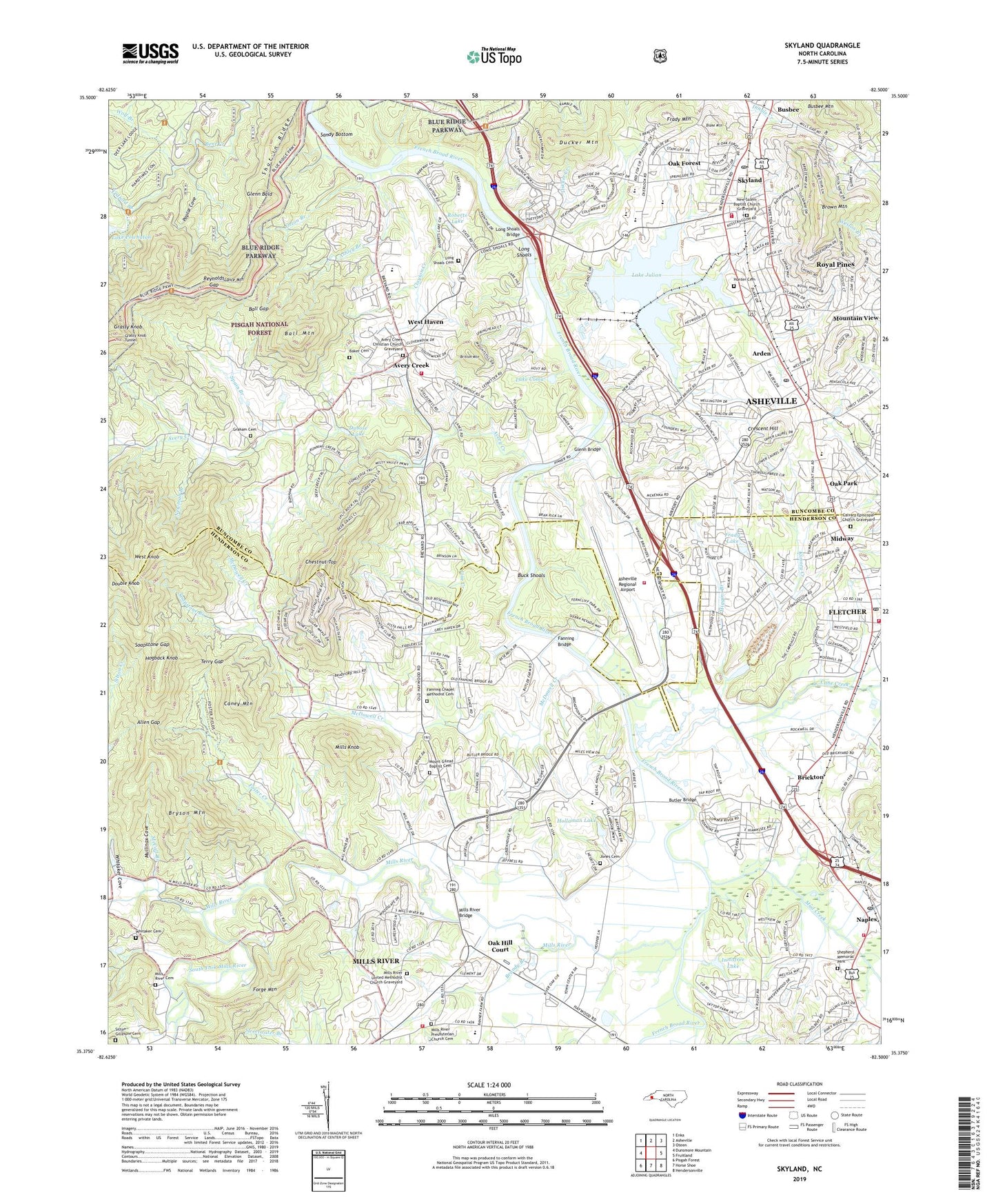
2022 topographic map quadrangle Skyland in the state of North Carolina. Scale: 1:24000. Based on the newly updated USGS 7.5' US Topo map series, this map is in the following counties: Henderson, Buncombe. The map contains contour data, water features, and other items you are used to seeing on USGS maps, but also has updated roads and other features. This is the next generation of topographic maps. Printed on high-quality waterproof paper with UV fade-resistant inks.
Quads adjacent to this one:
West: Dunsmore Mountain
Northwest: Enka
North: Asheville
Northeast: Oteen
East: Fruitland
Southeast: Hendersonville
South: Horse Shoe
Southwest: Pisgah Forest
This map covers the same area as the classic USGS quad with code o35082d5.
Contains the following named places: Allen Gap, Arden, Arden Post Office, Asheville Fire Department Station 4, Asheville Regional Airport, Asheville Regional Airport Department of Public Safety Rescue Fire Stations, Asheville Steam Plant, Ashley Branch, Avery Creek, Avery Creek Census Designated Place, Avery Creek Christian Church Graveyard, Baker Cemetery, Ball Gap, Ball Mountain, Bethel Church, Big F Shopping Center, Biltmore Farms, Blake Mountain, Boiling Springs Church, Brandy Branch, Brickton, Brickton Church, Britton Mountain, Brown Mountain, Bryson Mountain, Buck Shoals, Busbee, Busbee Community Center, Busbee Post Office, Butler Bridge, Calvary Church, Calvary Episcopal Church Graveyard, Camp Clark-Kennedy, Camp Deer Lake, Cane Creek, Caney Mountain, Capps Lake, Chestnut Top, Clayton Creek, Crescent Hill, Crosspoint Church, Cushion Branch, Double Knob, Dubose Lake, Ducker Creek, Ducker Mountain, Emmanuel Church, Fanning Bridge, Fanning Chapel, Fanning Chapel Methodist Cemetery, Fletcher, Fletcher Fire and Rescue Department Station 1, Fletcher Fire and Rescue Department Station 3, Fletcher First Baptist Church, Fletcher Plaza, Fletcher Post Office, Fletcher Quarry, Fletcher School, Fletcher United Methodist Church, Foster Creek, Frady Lake, Frady Mountain, Glen Arden Elementary School, Glenn Bald, Glenn Bridge, Graham Cemetery, Grassy Knob Tunnel, Hayes Mill, Higgins Branch, Hogback Knob, Hollaman Lake, Holloman Pond Dam, Hunter Cemetery, Innisfree Lake, Jones Cemetery, Kates Park, Kimsey Creek, Lake Coma, Lake Julian, Lake Powhatan Dam, Lance Mountain, Ledford Branch, Line Creek, Long Shoals, Long Shoals Bridge, Long Shoals Cemetery, Looking Glass Montessori School - Rosman, Lutheridge Camp, Lutheridge Chapel, McCall Branch, McDowell Creek, Midway, Mills Knob, Mills River, Mills River Bridge, Mills River Cemetery, Mills River Chapel, Mills River Church, Mills River Presbyterian Church Cemetery, Mills River School, Mills River United Methodist Church Graveyard, Mills River Volunteer Fire and Rescue, Mount Carmel Church, Mount Gilead Baptist Cemetery, Mount Gilead Church, Mount Zion Church, Mountain View, Mud Creek, Mullinax Cove, Naples, Naples Church, Naples Post Office, Nativity Church, NC Noname Two-Hundred Sixty Dam, New Salem Baptist Church Graveyard, New Salem Church, Newman Branch, North Fork Mills River, Oak Forest, Oak Grove Christian Church, Oak Hill Court, Oak Park, Orton Branch, Poplar Cove, Reynolds Gap, Ritter Airpark, Roberts Lake, Royal Pines, Royal Pines Census Designated Place, Saint Barnabas Church, Saint Johns Church, Sandy Bottom, Shepherd Memorial Park, Shut-in Ridge, Sitton - Gillespie Cemetery, Skyland, Skyland Fire and Rescue, Skyland Fire and Rescue Avery Creek Station, Skyland Post Office, Soapstone Branch, Soapstone Gap, South Fork Mills River, Spain Branch, Taylor Dam, TC Roberson High School, Terry Gap, Town of Fletcher, Town of Mills River, Township of Avery Creek, Township of Limestone, Valley Springs School, Wesley Creek, West Haven, West Knob, Whitaker Cemetery, Whitaker Cove, William W Estes Elementary School, Wolf Branch, ZIP Codes: 28704, 28759