MyTopo
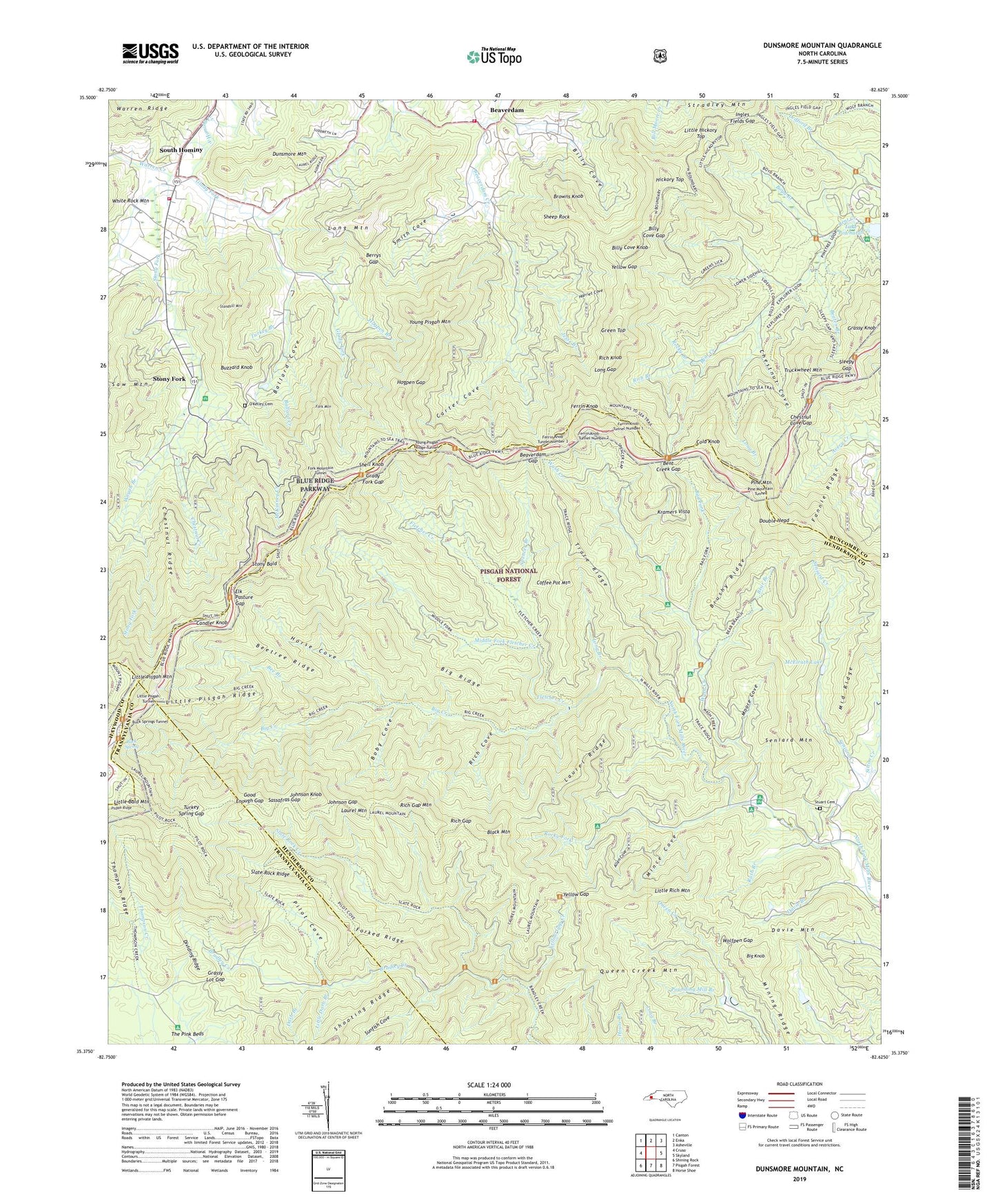
Dunsmore Mountain North Carolina US Topo Map
Couldn't load pickup availability
Also explore the Dunsmore Mountain Forest Service Topo of this same quad for updated USFS data
2022 topographic map quadrangle Dunsmore Mountain in the state of North Carolina. Scale: 1:24000. Based on the newly updated USGS 7.5' US Topo map series, this map is in the following counties: Buncombe, Henderson, Transylvania, Haywood. The map contains contour data, water features, and other items you are used to seeing on USGS maps, but also has updated roads and other features. This is the next generation of topographic maps. Printed on high-quality waterproof paper with UV fade-resistant inks.
Quads adjacent to this one:
West: Cruso
Northwest: Canton
North: Enka
Northeast: Asheville
East: Skyland
Southeast: Horse Shoe
South: Pisgah Forest
Southwest: Shining Rock
This map covers the same area as the classic USGS quad with code o35082d6.
Contains the following named places: Allen Cove, Bad Fork, Ballard Cove, Ballard Creek, Bear Branch, Beaten Branch, Beaverdam, Beaverdam Gap, Bee Branch, Beetree Ridge, Bent Creek Experimental Forest, Bent Creek Gap, Berrys Gap, Big Creek, Big Knob, Big Ridge, Billy Cove, Billy Cove Gap, Billy Cove Knob, Black Mountain, Boby Cove, Boyd Branch, Browns Knob, Browns View Church, Brushy Ridge, Buck Spring Gap, Buck Springs Lodge, Buck Springs Tunnel, Buzzard Knob, Candler Knob, Carter Cove, Chestnut Cove, Chestnut Cove Gap, Chestnut Creek, Chestnut Ridge, Coffee Pot Mountain, Cold Knob, Darb Branch, Davie Branch, Davie Mountain, Davis Chapel Church, Dividing Ridge, Double Head, Dunsmore Mountain, Elk Pasture Gap, Fannie Ridge, Ferin Fire Tower, Ferrin Knob, Ferrin Knob Tunnel Number 1, Ferrin Knob Tunnel Number 2, Ferrin Knob Tunnel Number 3, Fletcher Creek, Fork Mountain, Fork Mountain Tunnel, Forked Ridge, Glady Fork, Good Enough Gap, Grady Fork Gap, Grassy Knob, Grassy Lot Gap, Green Top, Harriet Cove, Hendersonville Reservoir, Hickory Top, Hogpen Branch, Hogpen Gap, Horse Cove, Ingles Fields Gap, Jesse Branch, Johnson Gap, Johnson Knob, Kramers Vista, Lake Powhatan, Lake Powhatan Campground, Laurel Hill Church, Laurel Mountain, Laurel Mountain Trail, Laurel Ridge, Little Bald Mountain, Little Darb Branch, Little Hickory Top, Little Pisgah Mountain, Little Pisgah Ridge, Little Pisgah Tunnel, Little Rich Mountain, Long Branch, Long Gap, Long Mountain, McElrath Lake, McKinney Creek, Middle Fork Fletcher Creek, Middle Ridge, Mince Cove, Mining Ridge, Moore Cove, Mount Pisgah Church, North Mills River Recreation Area, O'Kelley Cemetery, Pilot Cove, Pilot Rock, Pilot Rock Trail, Pine Mountain, Pine Mountain Tunnel, Pisgah Church, Pounding Mill Branch, Powhatan Recreation Area, Queen Creek Mountain, Reed Cove, Rich Branch, Rich Cove, Rich Gap, Rich Gap Mountain, Rich Knob, Rocky Branch, Rocky Fork, Rush Branch, Sassafras Gap, Saw Mountain, Seniard Creek, Seniard Mountain, Sheep Rock, Shell Knob, Shut-In Trail, Side Hill Trail, Sitton Creek, Slate Rock Creek, Slate Rock Ridge, Sleepy Gap, Smith Cove, South Hominy, Spencer Branch, Standhill Mountain, Stony Bald, Stony Fork, Stony Fork Church, Stony Fork Recreation Site, Stradley Mountain, Stuart Cemetery, Sunfish Cove, Thompson Ridge Trail, Township of Mills River, Trace Ridge, Truckwheel Mountain, Turkey Branch, Turkey Spring Gap, Upper Hominy Volunteer Fire and Rescue Department, Upper Hominy Volunteer Fire and Rescue Department Station 2, Warren Creek, Wash Creek, Wayah Branch, Wolfpen Gap, Yellow Gap, Yellow Gap Creek, Young Pisgah Mountain, Young Pisgah Ridge Tunnel, ZIP Code: 28742