MyTopo
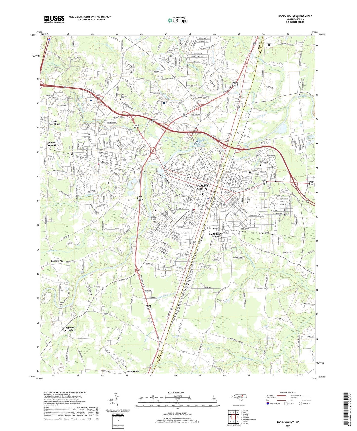
Rocky Mount North Carolina US Topo Map
Couldn't load pickup availability
2019 topographic map quadrangle Rocky Mount in the state of North Carolina. Scale: 1:24000. Based on the newly updated USGS 7.5' US Topo map series, this map is in the following counties: Nash, Edgecombe. The map contains contour data, water features, and other items you are used to seeing on USGS maps, but also has updated roads and other features. This is the next generation of topographic maps. Printed on high-quality waterproof paper with UV fade-resistant inks.
Quads adjacent to this one:
West: Nashville
Northwest: Red Oak
North: Drake
Northeast: Whitakers
East: Hartsease
Southeast: Pinetops
South: Elm City
Southwest: Winstead Crossroads
Contains the following named places: Ashburk, Avalon Church, Baskerville School, Bassett School, Battle Community Building, Battle School, Baxter School, Bel-Air, Benevenue Country Club, Benvenue Church, Benvenue Country Club, Benvenue Middle School, Benvenue School, Berkeley, Bethlehem Church, Bethlehem School, Bible Missionary Church, Boone School, Braswell School, Brook Valley Trailer Park, Bryant T Auldridge Rehabilitation Center, Buck Leonard Park, Cedar Grove Church, City Lake, City of Rocky Mount, Coastal Plain Hospital, Compass Creek, Cowlick Branch, Easonburg, Edgecombe Park Shopping Center, Edgecombe Technical Institute, Edwards Junior High School, Englewood Church, Englewood School, Englewood Square Shopping Center, Englewood United Church, Faith Tabernacle, Farmington, Forest Oaks, Fountain Correctional Facility, Fountain School, Fox Run, Freewill Church, Golden East Crossing Shopping Center, Golden Leaf Center, Goose Branch, Gorham School, Grape Branch, Green Hills Trailer Park, Griffin School, Halifax Crossing, Hicks Branch, High Meadows, Holland School, Hornbeam Branch, Johnson School, Joyner School, Joyners Crossing, KVK, Lakeside Church, Lemons Bridge, LifeCare Hospitals of North Carolina, Little Easonburg, Little Falls, Maple Creek, Meadow Brook, Meadowbrook Park, Metropolitan Church, Mill Branch Church, Mobile City Trailer Park, Mount Olive Church, Nash County Emergency Medical Services Station 700, Nash County Emergency Medical Services Station 800, Nash General Hospital, New Christian Academy, North Green, Northeastern Cemetery, Oak View Church, Oakwood Shopping Center, Parker Junior High School, Parkwood Church, Pineview Cemetery, Pleasant Grove Church, Polecat Branch, Pope School, Powell School, Proctors Church, Quail Hollow, Raleigh Road Shopping Center, Rock Mount Community Center, Rocky Mount, Rocky Mount Academy, Rocky Mount Annex Post Office, Rocky Mount Downtown Airport, Rocky Mount Fire Department Station 1, Rocky Mount Fire Department Station 2, Rocky Mount Fire Department Station 3, Rocky Mount Fire Department Station 5, Rocky Mount Fire Department Station 6, Rocky Mount High School, Rocky Mount Mill Pond, Rocky Mount Millpond Dam, Rocky Mount Mills, Rocky Mount Municipal Stadium, Rocky Mount Police Department, Rocky Mount Post Office, Rocky Mount W Base, Saint Andrews Church, Shiloh Church, South Rocky Mount, Spring Green Church, Stony Creek, Stony Creek Rescue Fire Department Station 3, Sunset Avenue Church, Sunset Park, Swelton Heights, Tarrytown Mall, Thornes Church, Thorpe School, Township of Rocky Mount, Township of Stony Creek, Union Branch Church, Union Missionary Church, Unity Cemetery, Upper Falls, Victory Church, WCEC-AM (Rocky Mount), WEED-AM (Rocky Mount), West Mount Church, West Mount Volunteer Fire Department, West Rocky Mount Post Office, Westridge Post Office, Westview Church, WFMA-FM (Rocky Mount), Wilkinson School, Williford Bridge, Williford School, Wilson Junior High School, Winsteads Chapel, Woodcrest Park, Woodgreen, Woodridge, WRMT-AM (Rocky Mount), ZIP Codes: 27803, 27804