MyTopo
Sams Gap North Carolina US Topo Map
Couldn't load pickup availability
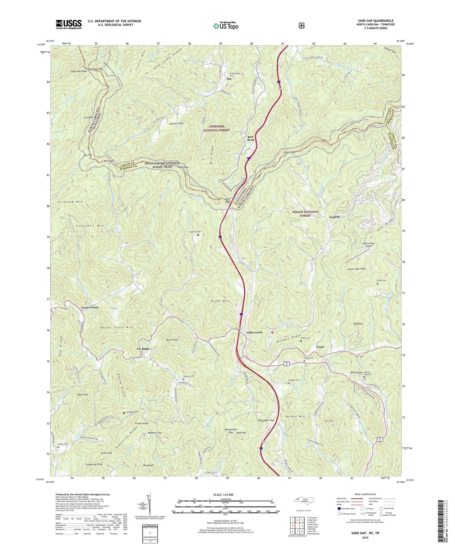
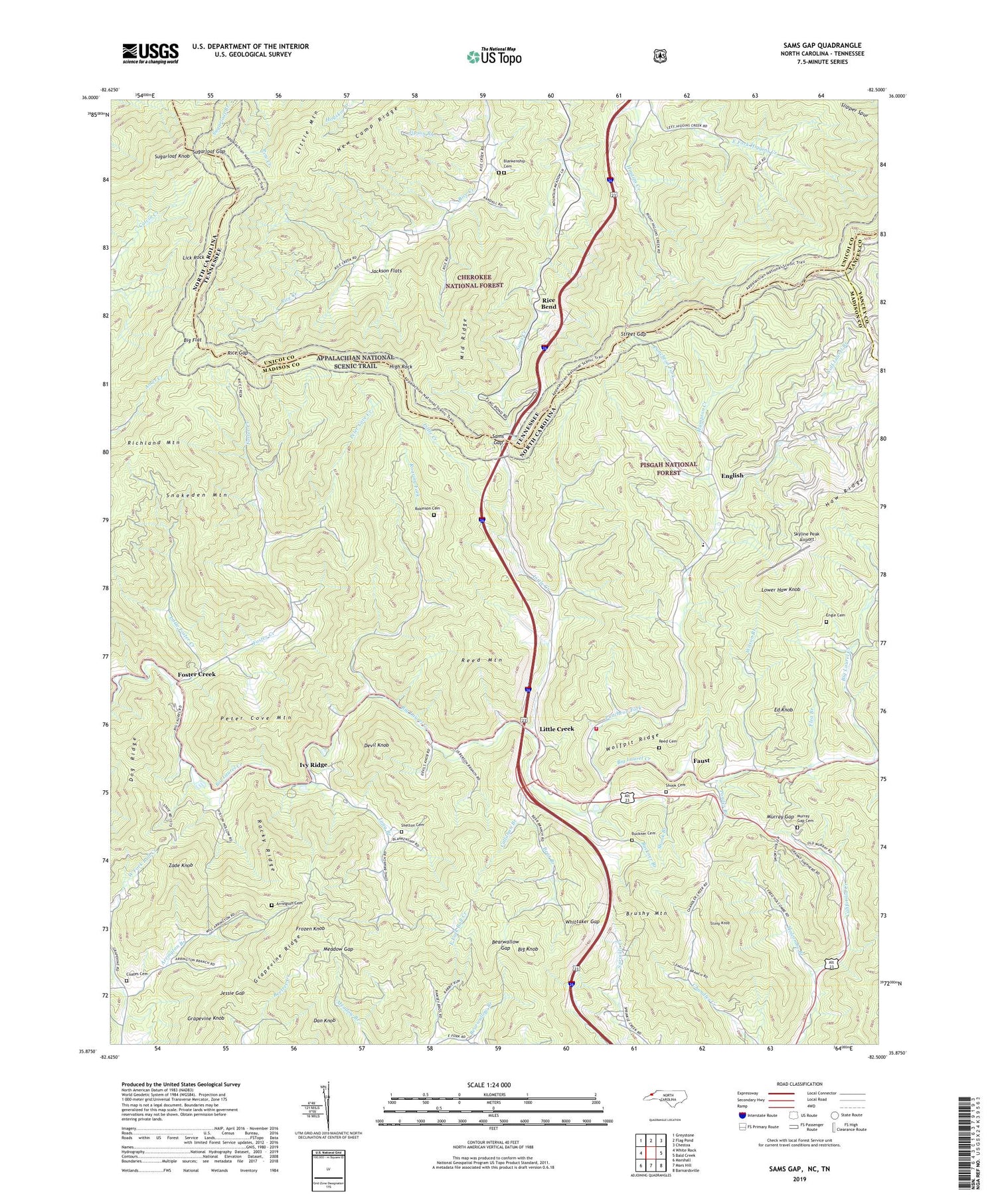
2019 topographic map quadrangle Sams Gap in the states of North Carolina, Tennessee. Scale: 1:24000. Based on the newly updated USGS 7.5' US Topo map series, this map is in the following counties: Madison, Unicoi, Yancey. The map contains contour data, water features, and other items you are used to seeing on USGS maps, but also has updated roads and other features. This is the next generation of topographic maps. Printed on high-quality waterproof paper with UV fade-resistant inks.
Quads adjacent to this one:
West: White Rock
Northwest: Greystone
North: Flag Pond
Northeast: Chestoa
East: Bald Creek
Southeast: Barnardsville
South: Mars Hill
Southwest: Marshall
Contains the following named places: Arrington Branch, Arrington Branch Church, Arrington Cemetery, Bear Branch, Bearwallow Gap, Big Flat, Big Knob, Big Knob Lookout, Blankenship Cemetery, Bradley Branch, Bright Hope Church, Bright Hope School, Brushy Mountain, Buckner Branch, Buckner Cemetery, Callahan Branch, Coates Cemetery, Dan Knob, Devil Knob, Divide Mountain, Dog Ridge, Ebb Chapel, Ebbs Chapel Volunteer Fire Department, Ed Knob, Engle Cemetery, English, Faust, Flea Branch, Foster Creek, Frozen Knob, Grapevine Knob, Grapevine Ridge, Hack Gap, Halls Store, Hampton Creek, Haw Ridge, Higgins Chapel, High Rock, Hogback Ridge, Holcombe Branch, Ivy Ridge, Jackson Flats, Jessie Gap, Laurel Bend Church, Laurelton Chapel, Lick Rock, Little Creek, Little Creek Church, Little Foster Creek, Little Mountain, Long Branch, Lower Haw Knob, Meadow Gap, Middle Ridge, Murray Gap, Murray Gap Cemetery, New Camp Ridge, Peter Cove Creek, Peter Cove Mountain, Pleasant Valley Church, Ponder Branch, Puncheon Fork, Ramsey Ridge, Reed Cemetery, Reed Mountain, Rice Bend, Rice Bend Church, Rice Creek School, Rice Gap, Roaring Fork, Robinson Cemetery, Rocky Ridge, Sams Gap, Shady Grove Baptist Church, Shady Grove School, Shelton Cemetery, Shook Branch, Shook Cemetery, Skyline Peak Airport, Smith Branch, Snakeden Mountain, Stamp Ridge, Stony Knob, Street Gap, Sugarloaf Gap, Sugarloaf Knob, Tipson Branch, Township 7-Ebbs Chapel, Upper Grapevine School, Upper Laurel Church, Walnut Mountains, Whittaker Gap, Wilson Branch, Wolf Laurel Branch, Wolfpit Ridge, Zade Knob, ZIP Code: 28754