MyTopo
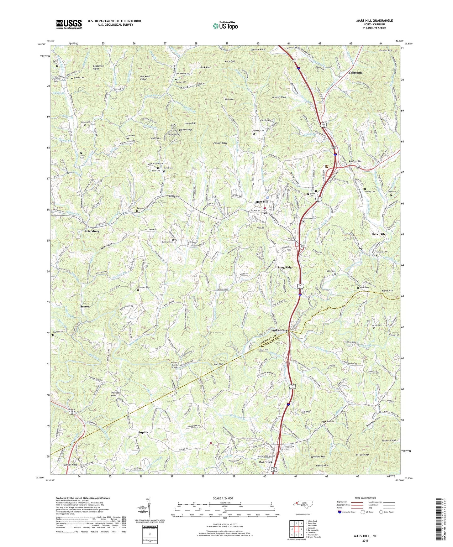
Mars Hill North Carolina US Topo Map
Couldn't load pickup availability
2022 topographic map quadrangle Mars Hill in the state of North Carolina. Scale: 1:24000. Based on the newly updated USGS 7.5' US Topo map series, this map is in the following counties: Madison, Buncombe. The map contains contour data, water features, and other items you are used to seeing on USGS maps, but also has updated roads and other features. This is the next generation of topographic maps. Printed on high-quality waterproof paper with UV fade-resistant inks.
Quads adjacent to this one:
West: Marshall
Northwest: White Rock
North: Sams Gap
Northeast: Bald Creek
East: Barnardsville
Southeast: Craggy Pinnacle
South: Weaverville
Southwest: Leicester
This map covers the same area as the classic USGS quad with code o35082g5.
Contains the following named places: Adkins Branch, Ammons Branch, Bailey Gap, Bailey Ridge, Banjo Branch, Bearwallow Branch, Beech Glen, Beetree Creek, Big Branch, Bill Cole Mountain, Blackstock Branch, Blackstock Cemetery, Bone Camp Creek, Buck Knob, Buckner Cemetery, Bull Creek, Bull Creek Church, Bull Creek School, Bull Hole, California, California Creek, Cargle Branch, Carter Cemetery, Center School, Chandler Creek, Cody Branch, Connor Ridge, Dan Knob Ridge, Dans Branch, Dill Branch, Dill Cemetery, East Fork Bull Creek, Ebenezer Cemetery, Edwards Cemetery, Eller Branch, Ephraim Knob, Farmer Field, Fisher Branch, Flat Creek, Flat Creek Elementary School, Forks of Ivy, Gabriel Creek, Gabriel Creek Church, Gentry Branch, Gentry Gap, George Cemetery, Gibbs Cemetery, Gosnell Branch, Gosnell Cemetery, Grapevine Cemetery, Grapevine Church, Griffin Branch, Grooms Branch, Halewood Creek, Hamp Gap, Higgins Branch, Hobson Branch, Holcombe Branch, Hooker Knob, Hunter Branch, Hunter Cemetery, Ivy, Ivy Dam, Ivy Hill Cemetery, Ivy Hill Church, Jarvis Branch, Jupiter, Jupiter Volunteer Fire Department, Kent Hollow, Laurel Branch, Laurel Branch Church, Little Ivy Church, Little Ivy Creek, Locust Grove Church, Long Ridge, Madison County Ambulance Service, Mars Hill, Mars Hill Police Department, Mars Hill Post Office, Mars Hill Volunteer Fire Department, Mary Gap, Mc Elroy Cemetery, Meadow Branch, Merrill Cemetery, Middle Fork California Creek, Middle Mountain, Morgan Branch, Morgan Hill Church, Nowhere Branch, Old Bull Creek Church, Pack Saddle, Paint Fork, Palmer Ford Bridge, Peek Cemetery, Peek Chapel, Petersburg, Piney Mountain Church, Radford Gap, Ramsey Cemetery, Ray Cemetery, Red Oak Knob, Red Oak School, Rice Cemetery, Runion Cemetery, Sams Cemetery, Sexton, Sexton Church, Sprinkle Cemetery, Sprinkle Creek, Sprinkler Branch, Sprouse Branch, Stanley Branch, Stillhouse Branch, Stockton Cove, Sugar Camp Branch, Thomas Branch, Town of Mars Hill, Township 10 Grapevine, Township 3 Mars Hill, Township of Flat Creek, Walker Branch, West Fork Bull Creek, Whiteoak Creek, Whiteoak Knob, Whitt Cemetery, Whitt Hollow, Willis Gap, WVMH-FM (Mars Hill)