MyTopo
Marshall North Carolina US Topo Map
Couldn't load pickup availability
Also explore the Marshall Forest Service Topo of this same quad for updated USFS data
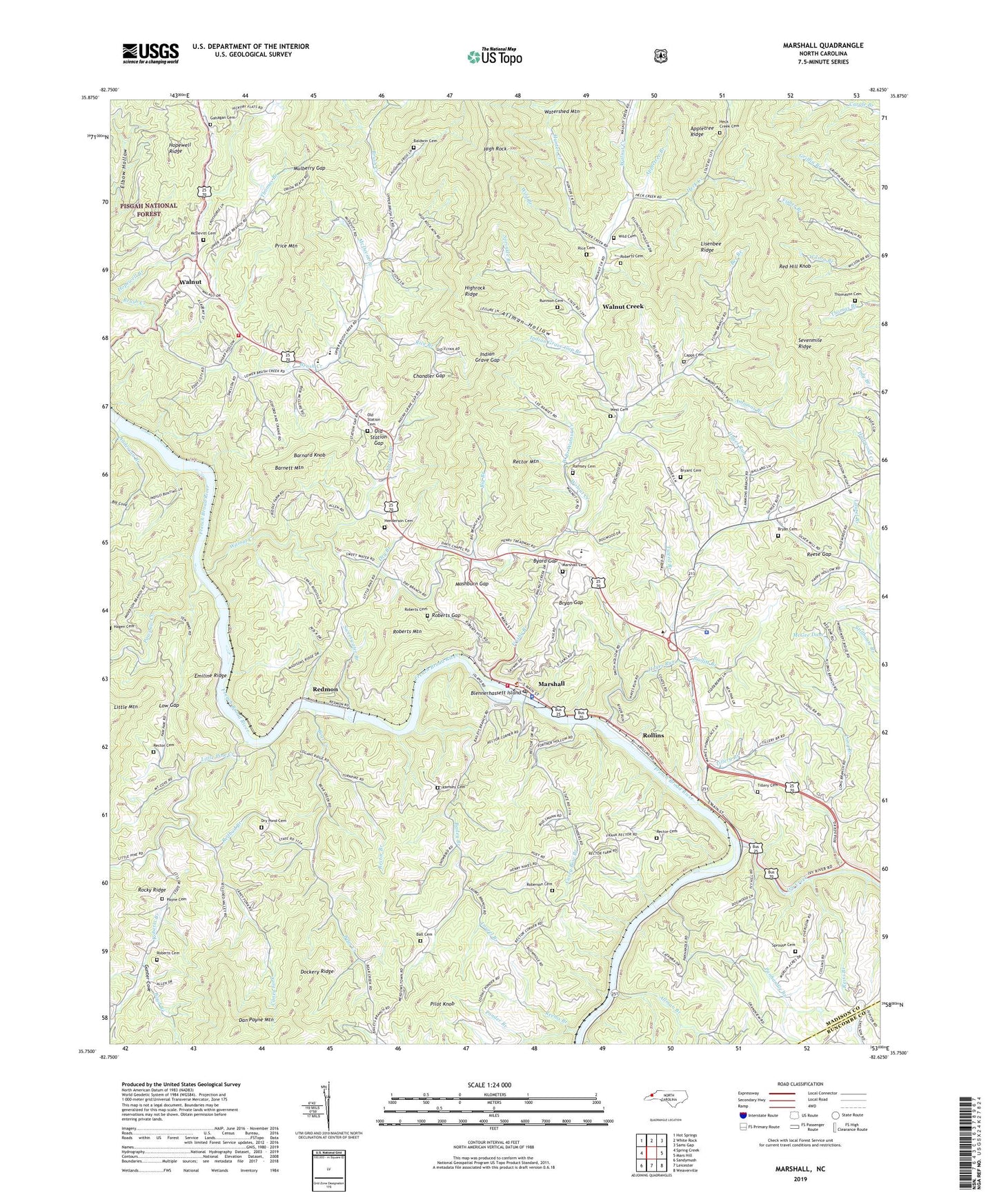
2022 topographic map quadrangle Marshall in the state of North Carolina. Scale: 1:24000. Based on the newly updated USGS 7.5' US Topo map series, this map is in the following counties: Madison, Buncombe. The map contains contour data, water features, and other items you are used to seeing on USGS maps, but also has updated roads and other features. This is the next generation of topographic maps. Printed on high-quality waterproof paper with UV fade-resistant inks.
Quads adjacent to this one:
West: Spring Creek
Northwest: Hot Springs
North: White Rock
Northeast: Sams Gap
East: Mars Hill
Southeast: Weaverville
South: Leicester
Southwest: Sandymush
This map covers the same area as the classic USGS quad with code o35082g6.
Contains the following named places: Allman Branch, Allman Hollow, Ammons Branch, Anderson Branch, Anderson Branch Church, Antioch Church, Appletree Branch, Bailey Branch, Baldwin Cemetery, Ball Cemetery, Barnard Knob, Barnett Mountain, Bear Creek, Bear Creek Church, Bee Branch, Big Branch, Big Cove, Blennerhassett Island, Boyd Branch, Bradmon Chapel, Bryan Cemetery, Bryan Gap, Bryant Cemetery, Byard Gap, Caney Fork, Caney Fork Church, Capps Cemetery, Casey Bow Branch, Chandler Gap, Dan Payne Mountain, Davis Chapel, Dockery Ridge, Dry Branch, Dry Branch Church, Dry Pond Cemetery, Elbow Hollow, Emiline Ridge, Enon Church, Frisby Branch, Gahagan Cemetery, Grand View Church, Gunter Cove, Hayes Run, Hayes Run Church, Heck Creek, Heck Creek Cemetery, Henderson Cemetery, High Rock, Hopewell Branch, Hopewell Ridge, Hunter Creek, Indian Grave Gap, Indian Grave Gap Branch, Ivy Creek, Jerry Ramsey Cemetery, Kalamazoo Church, Laurel Branch, Laurel Fork Church, Lisenbee Ridge, Little Pine Creek, Long Branch, Low Gap, Madison County, Madison County Ambulance Service, Madison County Sheriff's Office, Madison Seminary, Marshall, Marshall Cemetery, Marshall Community Volunteer Fire Department, Marshall Elementary School, Marshall Police Department, Marshall Post Office, Marshall Primary School, Marshall Watershed Lake, Mashburn Gap, McCrary-Madison Quarry, McDevitt Branch, McDevitt Cemetery, McGee Dam, Mount Zion Church, Mulberry Gap, NC Noname Two-Hundred Thirteen Dam, Nocona Siding, Oak Hill Church, Old Station Cemetery, Old Station Gap, Panhandle Branch, Pawpaw Creek, Payne Cemetery, Pilot Knob, Ponder Branch, Price Mountain, Profitt Branch, Ramsey Cemetery, Rector Branch, Rector Cemetery, Rector Chapel, Rector Mountain, Red Hill Church, Red Hill Knob, Redbud Branch, Redmon, Redmon Dam, Reems Branch, Reese Gap, Revis Branch, Rice Branch, Rice Cemetery, Roberson Cemetery, Roberts Branch, Roberts Cemetery, Roberts Gap, Roberts Mountain, Rollins, Runnion Cemetery, Sprinkle Branch, Sprouse Cemetery, Station Branch, Sweetwater Branch, Thomas Branch, Thomas Tillery Cemetery / Long Branch Church Cemetery, Thomason Cemetery, Tillery Branch, Town of Marshall, Township 1 Marshall, Township 1 North Marshall, Township 1 South Marshall, Tweed Branch, Walnut, Walnut Community Volunteer Fire Department, Walnut Creek, Watershed Mountain, West Branch Walnut Creek, West Cemetery, Wild Branch, Wild Cemetery, Wilson Branch, WMMH-AM (Marshall), ZIP Code: 28753