MyTopo
Southwest Eden North Carolina US Topo Map
Couldn't load pickup availability
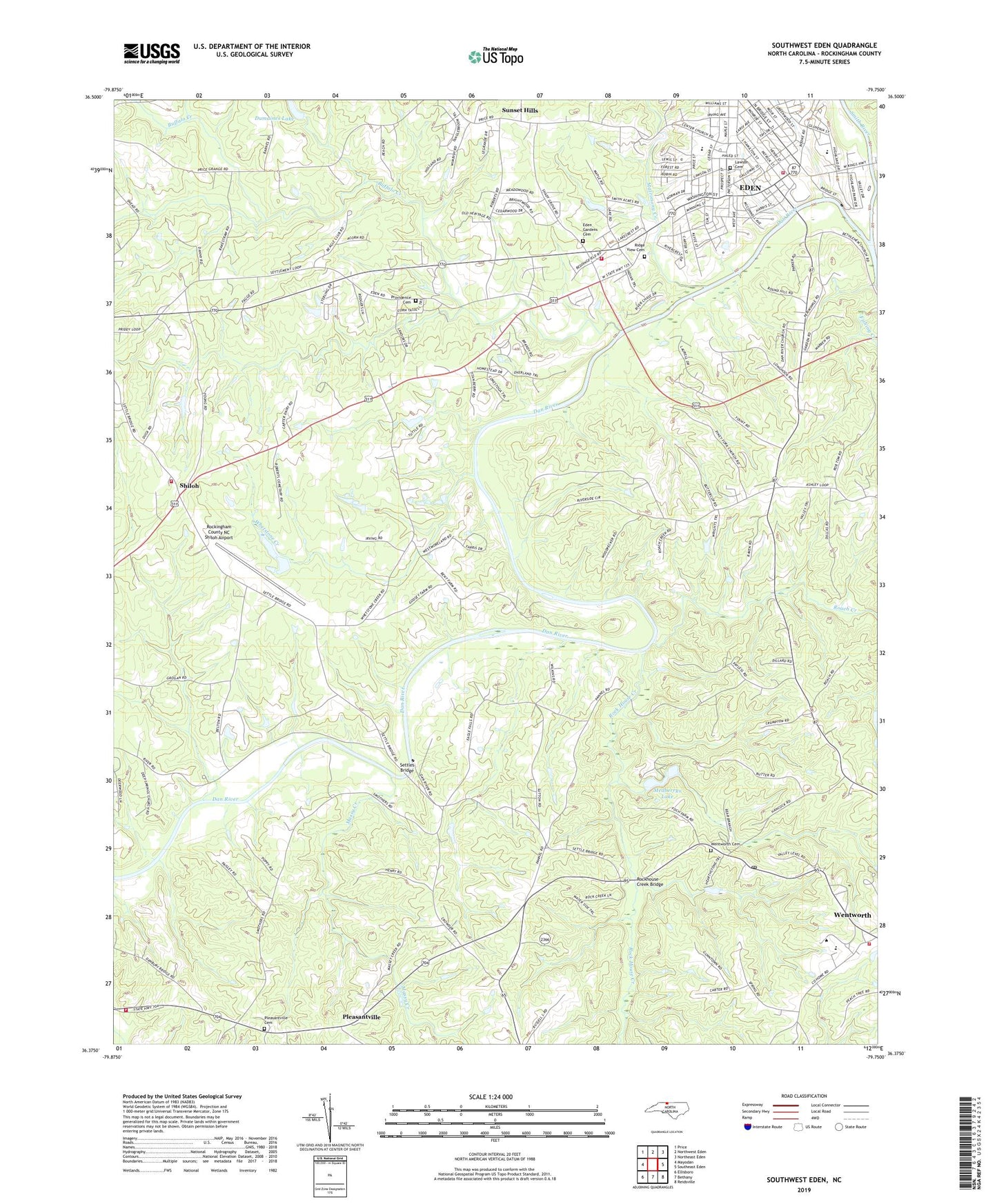
2022 topographic map quadrangle Southwest Eden in the state of North Carolina. Scale: 1:24000. Based on the newly updated USGS 7.5' US Topo map series, this map is in the following counties: Rockingham. The map contains contour data, water features, and other items you are used to seeing on USGS maps, but also has updated roads and other features. This is the next generation of topographic maps. Printed on high-quality waterproof paper with UV fade-resistant inks.
Quads adjacent to this one:
West: Mayodan
Northwest: Price
North: Northwest Eden
Northeast: Northeast Eden
East: Southeast Eden
Southeast: Reidsville
South: Bethany
Southwest: Ellisboro
This map covers the same area as the classic USGS quad with code o36079d7.
Contains the following named places: Barnes School, Buffalo Creek, Burton Grove School, Centenary Methodist Church, Dan River, Dan River Wesleyan Church, Dead Timbers Ford, Douglass High School, Dumaines Lake, Eden, Eden Fire Department Station 1, Eden Gardens Cemetery, Eden Plaza Shopping Center, Fellowship Baptist Church, Four Winds Farm Airport, Galloway School, Grassy Springs School, Green Knolls, Hampton Heights Church, Holly Hills, Homestead, Indian Hills, Jacobs Creek Fire Department, Kings Highway Christian Church, Kirkwood, Laurel Bluffs, Lawson Cemetery, Leaksville Junior High School, Leaksville Volunteer Fire Department, Little Bethlehem Christian Church, Massy Creek, Matrimony Creek, Meadowood, Medberrys Lake, Medberrys Lake Dam, Piney Fork, Piney Fork Primitive Baptist Church, Pleasantville, Pleasantville Primitive Baptist Church, Pleasantville Primitive Baptist Church Cemetery, Providence, Providence Baptist Church, Providence Baptist Church Cemetery, Ravenwood, Reywin Acres, Ridge View Cemetery, Riverbend, Roach Creek, Rock House Creek, Rockhouse Creek Bridge, Rockingham Community College, Rockingham County, Rockingham County Emergency Services Government Office, Rockingham County High School, Rockingham County NC Shiloh Airport, Saint Johns Church, Saint Marys by the Highway Episcopal Church, Saunders School, Settles Bridge, Settles Ridge Church, Shiloh, Shiloh Acres, Shiloh Fire Department, Shiloh Primitive Baptist Church, Smith Acres, Smith River, Smith River School, Smiths Lake, Smiths Lake Dam, Springfield Baptist Church, Sunset Hills, Town of Wentworth, Township of Wentworth, Tuttles Lake, Tuttles Lake Dam, Wentworth, Wentworth Elementary School, Wentworth Methodist Church Cemetery, Wentworth Post Office, Wentworth United Methodist Church, West Holly Hills, Whetstone Creek, Whipporrwill Hills, Whispering Pines, Windwood, Youngs Lake, Youngs Lake Dam, ZIP Code: 27288