MyTopo
Troutman North Carolina US Topo Map
Couldn't load pickup availability
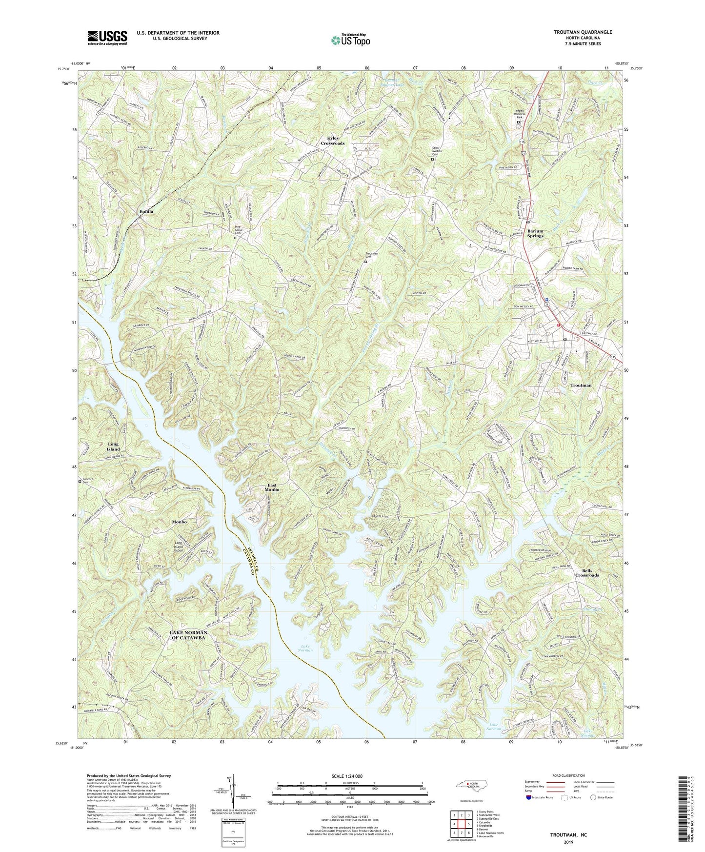
2022 topographic map quadrangle Troutman in the state of North Carolina. Scale: 1:24000. Based on the newly updated USGS 7.5' US Topo map series, this map is in the following counties: Iredell, Catawba. The map contains contour data, water features, and other items you are used to seeing on USGS maps, but also has updated roads and other features. This is the next generation of topographic maps. Printed on high-quality waterproof paper with UV fade-resistant inks.
Quads adjacent to this one:
West: Catawba
Northwest: Stony Point
North: Statesville West
Northeast: Statesville East
East: Shepherds
Southeast: Mooresville
South: Lake Norman North
Southwest: Denver
This map covers the same area as the classic USGS quad with code o35080f8.
Contains the following named places: Balls Creek, Barium Spring Orphanage Dam, Barium Springs, Barium Springs Post Office, Bass Creek, Bells Crossroads, Bethel Church, Concord Church, Concord United Methodist Church Cemetery, Duke Powder State Park, Duke Power Park Dam, Duke Power Park Lake, East Monbo, Eufola, Fern Hill Church, Hicks Creek, Iredell County Schools Special Services, Iredell Memorial Park, Kyles Crossroads, Little Joes Church, Long Island, Long Island Access Area, Long Island Airport, Long Island Marina, Monbo, Mountain Road Church, Noname, Norwood Creek, Olivet Church, Perth Church, Pine Grove Cemetery, Powder Spring Branch, Presbyterian Orphanage Dam, Reeder Creek, Rocky Creek, Rocky Mount Church, Saint James Church, Saint Johns Church, Saint Martins Cemetery, Saint Pauls Church, Skippers Landing, South Iredell High School, Stumpy Creek Access Area, Terrapin Creek, Town of Troutman, Township of Fallstown, Trinity Church, Troutman, Troutman Cemetery, Troutman Elementary School, Troutman Fire and Rescue Station, Troutman Police Department, Troutman Post Office, ZIP Code: 28677