MyTopo
Beverly Ohio US Topo Map
Couldn't load pickup availability
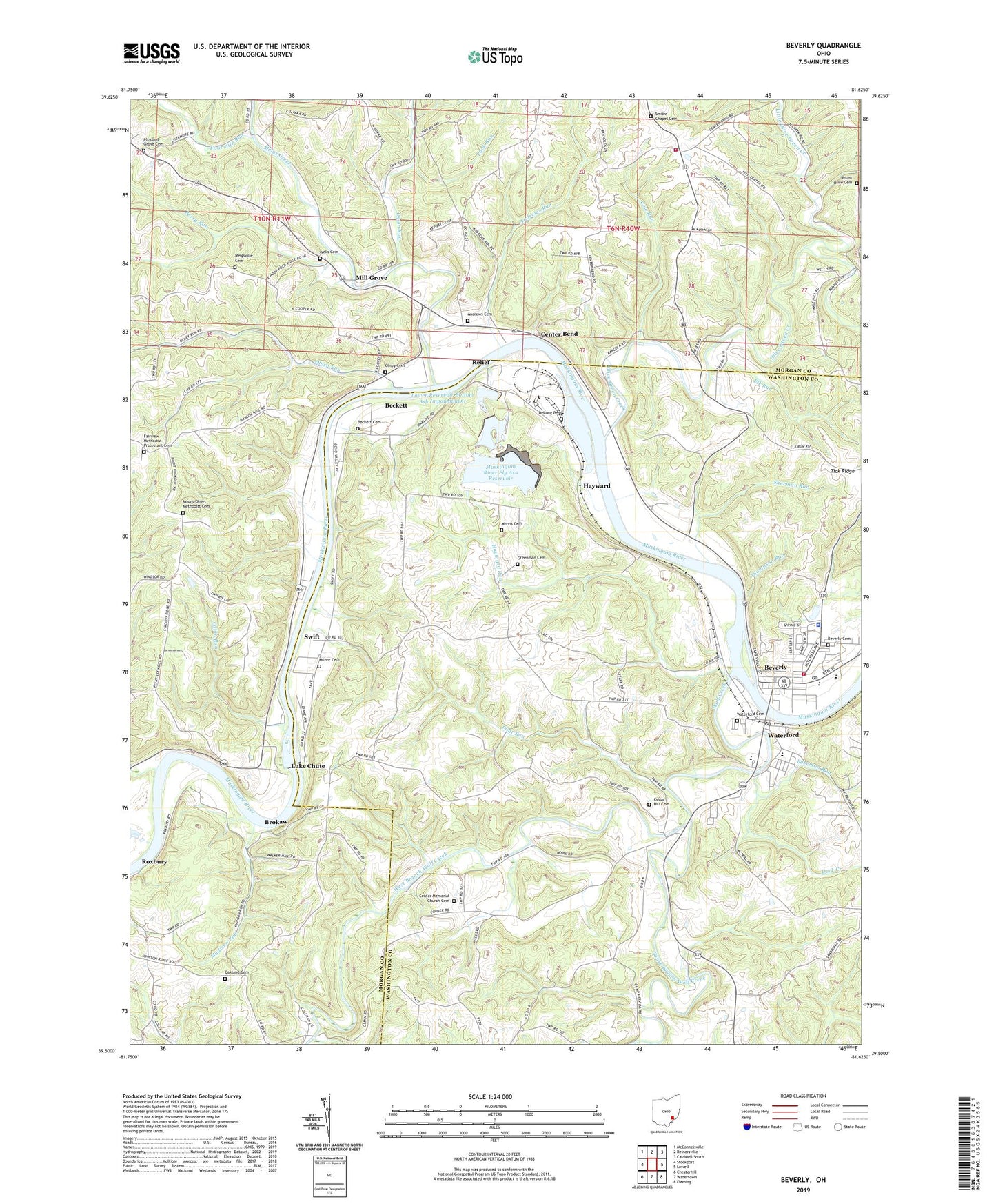
2019 topographic map quadrangle Beverly in the state of Ohio. Scale: 1:24000. Based on the newly updated USGS 7.5' US Topo map series, this map is in the following counties: Washington, Morgan. The map contains contour data, water features, and other items you are used to seeing on USGS maps, but also has updated roads and other features. This is the next generation of topographic maps. Printed on high-quality waterproof paper with UV fade-resistant inks.
Quads adjacent to this one:
West: Stockport
Northwest: McConnelsville
North: Reinersville
Northeast: Caldwell South
East: Lowell
Southeast: Fleming
South: Watertown
Southwest: Chesterhill
Contains the following named places: Andrews Cemetery, Andrews Run, Beckett, Beckett Cemetery, Beverly, Beverly - Waterford Township Rescue Squad, Beverly Cemetery, Beverly College, Beverly Elementary School, Beverly Post Office, Beverly Public School, Beverly Village Police Department, Beverly Volunteer Fire Department, Boseman Run, Brokaw, Brokaw Post Office, Buchanan School, Cabin Run, Cedar Hill Cemetery, Center Bend, Center Memorial Church, Center Memorial Church Cemetery, Center School, Center Township Volunteer Fire Department, Centerbend Post Office, Church of Christ, Colburn School, Cory School, Cow Run, DeLong Cemetery, Duck Creek, Elk Run, Fairview Church, Fairview Methodist Protestant Cemetery, Flint Run, Fort Frye High School, Fourmile Run, Grand View School, Greenman Cemetery, Hayward, Hayward Run, Hilldale School, Laurel Hill School, Little Olive Green Creek, Lower Reservoir Bottom Ash Dam, Lower Reservoir Bottom Ash Impoundment, Luck Run, Ludlow, Luke Chute, Madison Run, Maple Grove School, Meigs Creek, Meigsville Cemetery, Meigsville Church of Christ, Middle Reservoir Fly Ash Dam, Middle Reservoir Fly Ash Impoundment, Mill Grove, Mill Run, Millgrove Post Office, Milnor Cemetery, Morris Cemetery, Moscow Mills, Moscow Mills Post Office, Moscow School, Mount Olive Cemetery, Mount Olive Church, Mount Olivet Church, Mount Olivet Methodist Cemetery, Muskingum River Fly Ash Dam, Muskingum River Fly Ash Reservoir, Muskingum River Lock and Dam Number, Muskingum River Lock and Dam Number Five, Muskingum River Lock and Dam Number Four, North Watertown School, Oakland Cemetery, Oakland United Methodist Church, Olive Chapel, Olive Green Creek, Olivet School, Olney Cemetery, Olney Run, Onion Run, Perry Run, Pleasant Grove Cemetery, Pleasant Grove Presbyterian Church, Point Lookout School, Relief, Righteous Ridge School, Rose Hill School, Roxbury, Roxbury Post Office, Ruraldale School, Saint Bernards Church, Sherman Run, Smiths Chapel Cemetery, Smiths Chapel United Methodist Church, South Branch Wolf Creek, Swift, Thompson Run, Township of Waterford, Units 1-4 Bottom Ash Pond, Units 1-4 Bottom Ash Pond Dam, Village of Beverly, Waterford, Waterford Cemetery, Waterford Census Designated Place, Waterford High School, Waterford Post Office, Wells Cemetery, West Branch Wolf Creek, Wolf Creek, ZIP Codes: 45715, 45786