MyTopo
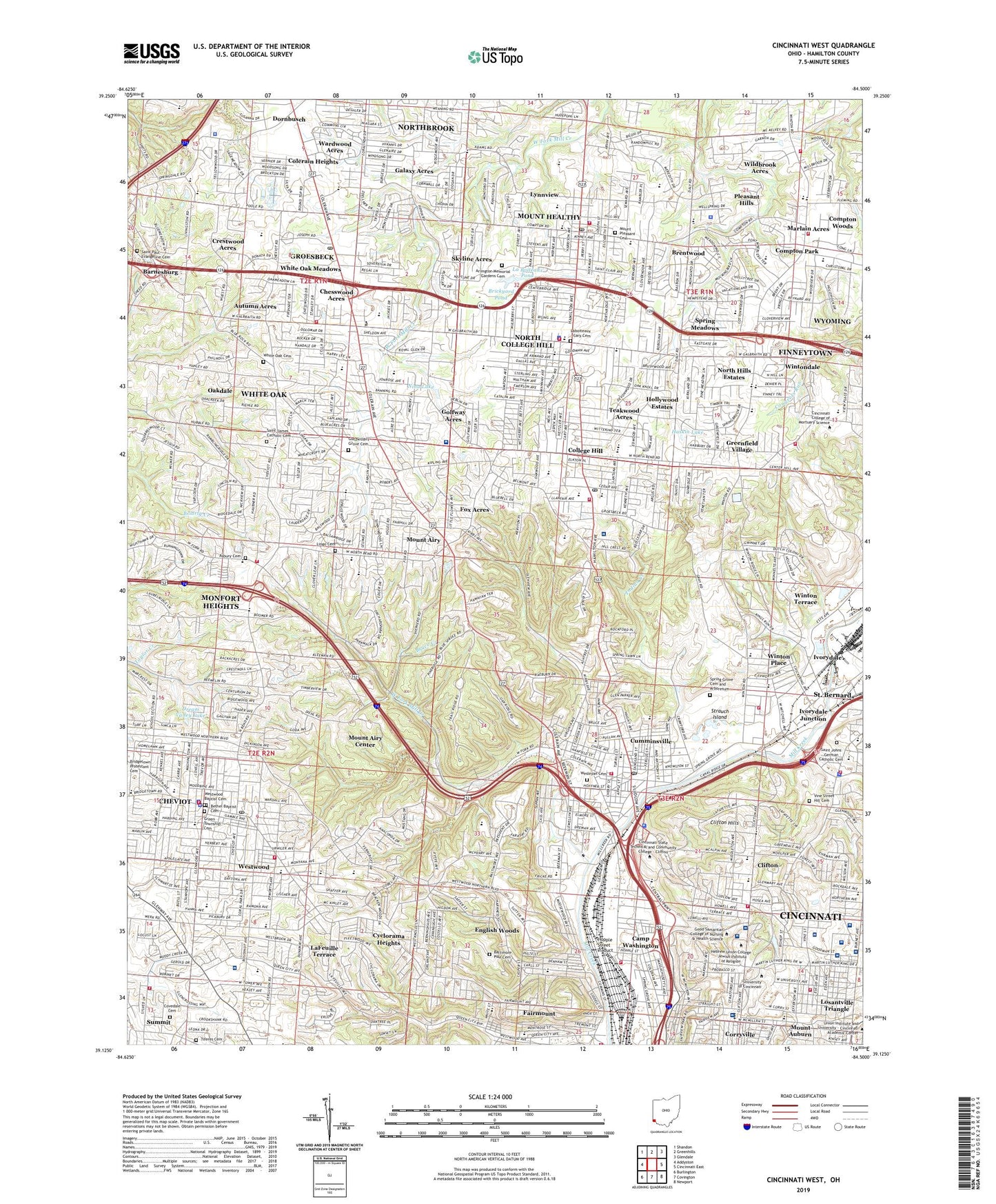
Cincinnati West Ohio US Topo Map
Couldn't load pickup availability
2023 topographic map quadrangle Cincinnati West in the state of Ohio. Scale: 1:24000. Based on the newly updated USGS 7.5' US Topo map series, this map is in the following counties: Hamilton. The map contains contour data, water features, and other items you are used to seeing on USGS maps, but also has updated roads and other features. This is the next generation of topographic maps. Printed on high-quality waterproof paper with UV fade-resistant inks.
Quads adjacent to this one:
West: Addyston
Northwest: Shandon
North: Greenhills
Northeast: Glendale
East: Cincinnati East
Southeast: Newport
South: Covington
Southwest: Burlington
This map covers the same area as the classic USGS quad with code o39084b5.
Contains the following named places: Abbe Meteorological Observatory, Aiken Senior High School, Arlington Memorial Gardens Cemetery, Asbury Cemetery, Autumn Acres, Avenue Grounds, Baltimore Pike Cemetery, Barnesburg, Barrett Cancer Center, Bethel Baptist Cemetery, Biddle Shop-Ette Shopping Center, Blue Rock Oval, Bosken Park, Bracken Woods Park, Brentwood, Brentwood Park, Brentwood Plaza Shopping Center, Brickyard Pond, Bron Bacevich Stadium, Bruce Creek, Burnett Woods, Cabin Run, Camp Washington, Campus Green, Careunit Hospital of Cincinnati, Center Hill Landfill, Chesswood Acres, Chester Park, Cheviot, Cheviot Municipal Swimming Pool, Childrens Hospital, Christina R Holmes Memorial Hospital, Cincinnati Children's Hospital College Hill, Cincinnati Children's Hospital Medical Center, Cincinnati Veterans Affairs Medical Center, Cincinnati Zoological Gardens, City of Cheviot, City of Cincinnati, City of Mount Healthy, City of North College Hill, Classon Park, Clifton, Clifton Farm, Clifton Heights, Clifton Hills, Clovernook Country Club, Colerain Heights, Colerain Hills Shopping Center, College Hill, College Hill Park, Compton Park, Corryville, Corryville Playground, Corryville Triangle Park, Covedale Cemetery, Coy Field, Crestwood Acres, Crossings of Colerain Shopping Center, Cumminsville, Cyclorama Heights, Deaconess Health Campus, Delco Plaza Shopping Center, Dornbusch, Dream Valley Lake, Edgewood Grove Park, Emery Park, English Woods, Fairmount, Farbach-Werner Nature Preserve, Felter Park, Finneytown, Finneytown Census Designated Place, Forest Avenue Wetland Park, Fox Acres, Fox Preserve, Frontier Park, Galaxy Acres, Girls Town of America, Golfway Acres, Good Samaritan Hospital, Good Samaritan Hospital Heliport, Green Township Cemetery, Greenfield Village, Groesbeck, Groesbeck Census Designated Place, Gutzwillers Grove Cemetery, Hamilton County, Hamilton County Dog Pound, Harvest Home Park, Haskin Lake, Haubner Field, Heritage Park, Hille Playground, Hilltop Plaza Shopping Center, Hoffner Historic District, Hollywood Estates, Holmes Hospital, Hopple Street Viaduct, Ivorydale Junction, Jacob Hoffner Park, Knowltons Corner, La Boiteaux Pond, La Boiteaux Woods, Laboiteaux - Cary Cemetery, Lafayette Circle, LaFeuille Terrace, Library Square, Lingo Cemetery, Losantville Triangle, Ludlow Monument, Lynnview, Lytle Park, Marlain Acres, McEvory Park, McFarlan Woods, McMicken Commons, Mecklenburgs Garden, Mercy Mount Airy Hospital, Mercy Western Hills Hospital, Monfort Heights, Monfort Heights Census Designated Place, Monfort Heights East Census Designated Place, Monfort Heights Shopping Center, Monfort Heights South Census Designated Place, Mount Airy, Mount Airy Center, Mount Airy Forest, Mount Airy Park, Mount Healthy, Mount Healthy Hatchery, Mount Pleasant Cemetery, Mount Storm Park, Newberry Wildlife Sanctuary, Nina Lake, Nippert Stadium, North Bend Crossing Shopping Center, North College Hill, North Hills Estates, North Hospital, Northbrook, Northbrook Census Designated Place, Northbrook Shopping Center, Northgate Mall Shopping Center, Northgate Square Shopping Center, Oakamp Playground, Oakdale, O'Connell Unit Good Samaritan Hospital, Parker Woods, Pleasant Hills, Pleasant Hills Census Designated Place, Rawson Woods, Receiving Hospital, Regency Hospital - Cincinnati, Rohs Hill, Ross Run, Saint Aloysius Gonzaga Catholic Cemetery, Saint Clair Heights Park, Saint Francis Hospital, Saint Jacobs, Saint James Catholic Cemetery, Saint John Cemetery, Saint Mary's Cemetery, Saint Paul Evangeline Cemetery, Saint Peter, Saint Peters Lick Run Historic District, Salway Park, Select Specialty Hospital - Cincinnati, Shepherd Creek, Shriners Burn Institute, Shriners Hospital for Children, Sigma Sigma Commons, Skyline Acres, Skyline Acres Census Designated Place, South Fairmount, South Fairmount Playground, Spring Grove Cemetery and Arboretum, Spring Meadows, Springfield Township Athletic Field, Strauch Island, Summit, Taft Field, Teakwood Acres, Tiferes Cemetery, Township of Springfield, Tremont Sanitarium, United Jewish Cemetery - Clifton, University Commons, University Hospital, University of Cincinnati Medical Center, University Plaza Shopping Center, Valley Park, Vine Street Hill Cemetery, WAKW-FM (Cincinnati), Warder Park, Wardwood Acres, Wayne Playground, WCET-TV (Cincinnati), WCIN-AM (Cincinnati), Werk Place, Wesleyan Cemetery, West Fork Mill Creek, Western Hills Plaza Shopping Center, Western Hills Pumping Station, Western Village Shopping Center, Western Woods Mall Shopping Center, Westwood, Westwood Baptist Cemetery, Westwood Common, Westwood Town Center Historic District, WGRR-FM (Hamilton), White Oak, White Oak Cemetery, White Oak Census Designated Place, White Oak East Census Designated Place, White Oak Meadows, White Oak Shopping Center, White Oak West Census Designated Place, Wildbrook Acres, Winton Commons, Winton Place, Winton Terrace, Wintondale, WOFX-FM (Fairfield), WSAI-AM (Cincinnati), WSTR-TV (Cincinnati), Zillig Pond Dam, ZIP Codes: 45211, 45219, 45220, 45223, 45224, 45225, 45231, 45232, 45239