MyTopo
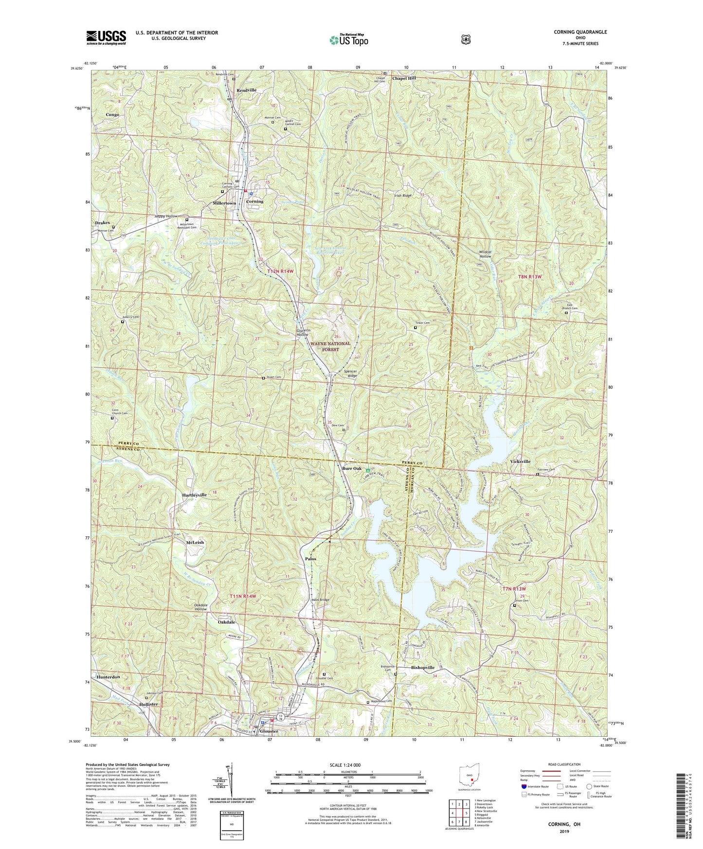
Corning Ohio US Topo Map
Couldn't load pickup availability
Also explore the Corning Forest Service Topo of this same quad for updated USFS data
2023 topographic map quadrangle Corning in the state of Ohio. Scale: 1:24000. Based on the newly updated USGS 7.5' US Topo map series, this map is in the following counties: Perry, Morgan, Athens. The map contains contour data, water features, and other items you are used to seeing on USGS maps, but also has updated roads and other features. This is the next generation of topographic maps. Printed on high-quality waterproof paper with UV fade-resistant inks.
Quads adjacent to this one:
West: New Straitsville
Northwest: New Lexington
North: Deavertown
Northeast: Rokeby Lock
East: Ringgold
Southeast: Amesville
South: Jacksonville
Southwest: Nelsonville
This map covers the same area as the classic USGS quad with code o39082e1.
Contains the following named places: Asberry Cemetery, Bishopville, Bishopville Cemetery, Bishopville Church of Christ, Bishopville Post Office, Bloody Run, Boat Dock Number 1, Boat Dock Number 2, Boat Dock Number 3, Boat Dock Number 4, Buckingham Mine Number 2, Burr Oak, Burr Oak Cove Recreation Site, Burr Oak Lodge, Burr Oak Lodge Heliport, Burr Oak Regional Water Treatment Plant, Burr Oak Reservoir, Burr Oak State Park, Cedar Run, Chapel Hill, Chapel Hill Cemetery, Chapel Hill Post Office, Congo, Congo Post Office, Conn Church, Conn Church Cemetery, Corning, Corning Catholic Cemetery, Corning Elementary School, Corning Post Office, Corning Village Police Department, Corning Volunteer Fire Department, Dew Cemetery, Dotson Creek, East Branch Cemetery, East Branch Church, East Branch Sunday Creek, Eels Run, Fairview Cemetery, Fairview Mission, First Baptist Church of Rendville, Glouster, Glouster Cemetery, Glouster Fire Department, Glouster Police Department, Glouster Post Office, Glycerin Hollow, Hamburg, Happy Hollow, Hartleyville, Hartleyville Post Office, Hatfield, Hoboken, Hollister, Hollister Post Office, Hunterdon, Indian Run, Irish Ridge, Johnson Cemetery, Johnson Run, Long Run, Maplewood Cemetery, McLeish, Millertown, Millertown Methodist Cemetery, Monroe Cemetery, Mount Carmel Cemetery, Mud Fork, New York Central Reservoir 9420, New York Central Reservoir Dam, Oakdale, Oakdale Hollow, Oakdale Post Office, Palos, Palos Bridge, Rendville, Rendville Cemetery, Rendville Post Office, Saint Bernard Catholic Church, San Toy Creek, Seimer Pond, Seimer Pond Dam, Southeast Ohio Emergency Medical Services Station 3 Glouster, Spencer Ridge, Spencer Ridge Church, Stuart Cemetery, Sunday Creek Coal Company Dam 9420-007 Dam, Sunday Creek Coal Company Pond 9420-0, Tinker Cemetery, Tom Jenkins Dam, Township of Monroe, Township of Trimble, Trimble Elementary School, Trimble Middle School, Trimble State Wildlife Area, Trimble Village Rescue Squad, Union Cemetery, Vicksville, Village of Corning, Village of Glouster, Village of Rendville, West Branch Sunday Creek, Wild Cat Hollow Hiking Trail, Wildcat Hollow, Wise School, ZIP Codes: 43730, 45732