MyTopo
East Liverpool North Ohio US Topo Map
Couldn't load pickup availability
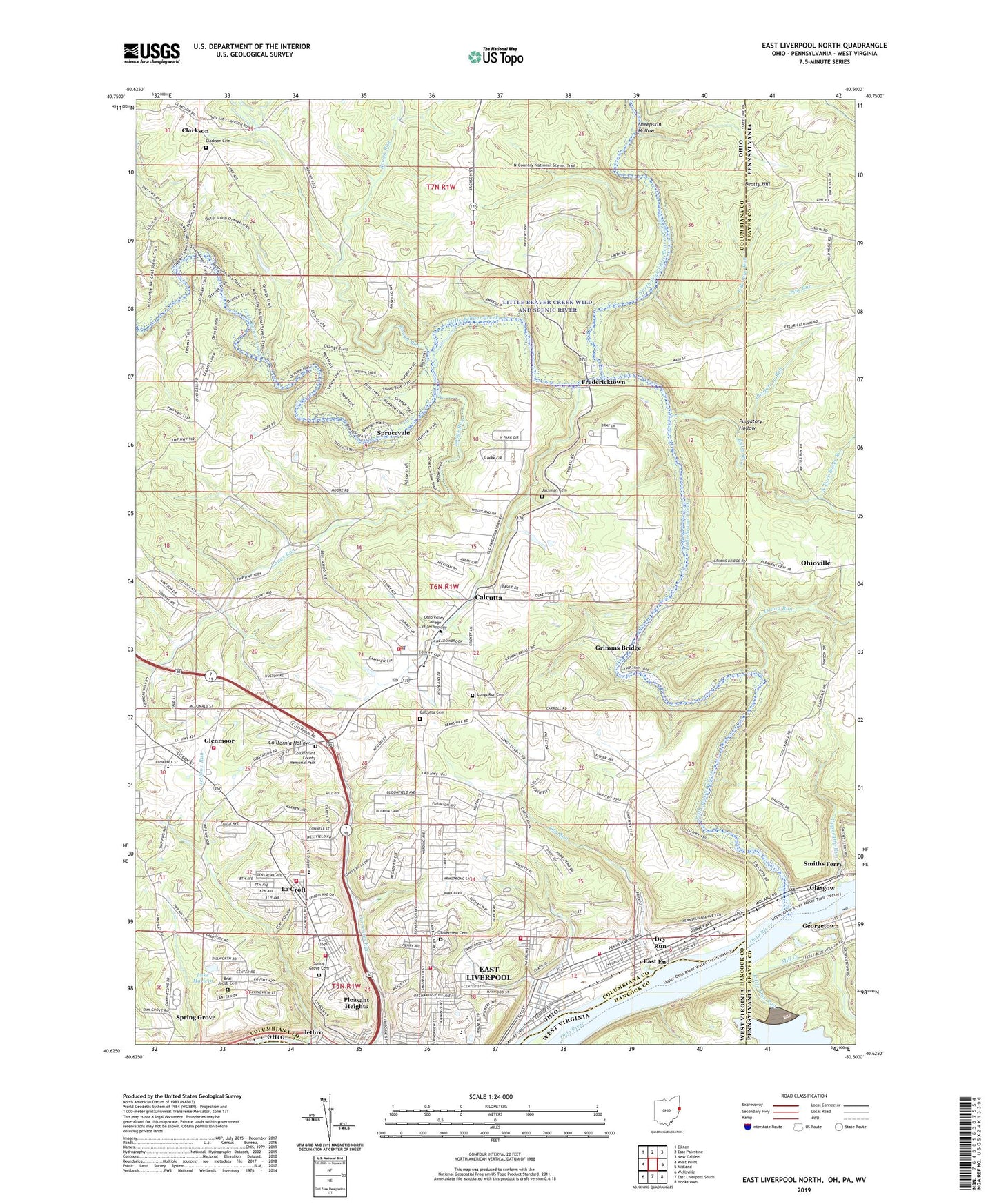
2023 topographic map quadrangle East Liverpool North in the states of Ohio, Pennsylvania, West Virginia. Scale: 1:24000. Based on the newly updated USGS 7.5' US Topo map series, this map is in the following counties: Columbiana, Beaver, Hancock. The map contains contour data, water features, and other items you are used to seeing on USGS maps, but also has updated roads and other features. This is the next generation of topographic maps. Printed on high-quality waterproof paper with UV fade-resistant inks.
Quads adjacent to this one:
West: West Point
Northwest: Elkton
North: East Palestine
Northeast: New Galilee
East: Midland
Southeast: Hookstown
Southwest: Wellsville
Contains the following named places: Babbs Island, Beatty Hill, Beaver Creek Church Camp, Bieler Run, Bnai Jacob Cemetery, Borough of Glasgow, Boyce Methodist Church, Calcutta, Calcutta Cemetery, Calcutta Census Designated Place, Calcutta Elementary School, Calcutta Post Office, Calcutta United Presbyterian Church, Calcutta Volunteer Fire Department, Camp Echo Dell, Cannons Mill, Cannons Mill Post Office, City of East Liverpool, Clarkson, Clarkson Cemetery, Clarkson Post Office, Clarkson Presbyterian Church, Columbian Park, Columbiana County Memorial Park, Dogwood Trail, Dry Run, East Branch Pine Run, East Elementary School, East End, East Liverpool Country Club, East Liverpool Filtration Plant, East Liverpool Fire Department Station 2, East Liverpool Fire Department Station 3, East Liverpool Fire Department Station 4, East Liverpool High School, East Liverpool Seaplane Base, Echo Dell Mobile Home Park, Etruria Street Church of God, Farr Hill Mobile Home Park, Fellowship Tabernacle Church, First Presbyterian Church, Fishermans Trail, Fredericktown, Fredericktown Christian Church, Garfield School, Gastons Mill, Glasgow, Glendale, Glenmoor, Glenmoor Census Designated Place, Glenmoor United Presbyterian Church, Glenmoor Volunteer Fire Department, Gretchens Lock Trail, Grimms Bridge, Hambletons Mill, Highland Country Club, Horace Mann Public School, Island Run, Jackman Cemetery, Jethro, Klondyke School, La Croft, La Croft Census Designated Place, La Croft Elementary School, Lacroft Church of the Nazarene, Lake Marwin, Lincoln School, Line Island, Little Beaver Creek, Little Beaver Creek Wild and Scenic River, Little Blue Run, Little Blue Run Dam, Liverpool Township Fire Department Dixonville Station, Liverpool Township Fire Department Lacroft Station, Longs Run, Longs Run Cemetery, Longs Run Church, Mill Creek, Mount Acres Trailer Park, Neville School, North Elementary School, North Fork Bieler Run, North Fork Little Beaver Creek, North Star Critical Care, Oak Grove School, Oakland Free Methodist Church, Ohio Valley Business College, Orchard Grove Methodist Episcopal Church, Pennsylvania Avenue United Methodist Church, Pine Run, Pleasant Heights, Prayer Temple Church, Purgatory Hollow, Purgatory Run, Riverview Cemetery, Rough Run, Saint Ann Catholic Church, Saint Clair Township Police Department, Santa Clara Estates, Second Baptist Church, Second Church of Christ, Second Presbyterian Church, Second United Presbyterian Church, Shadybrook Trailer Park, Sheepskin Hollow, Smiths Ferry, Spring Grove, Spring Grove Cemetery, Sprucevale, Sprucevale Post Office, Taft School, Thompson Park, Township of Liverpool, Township of Saint Clair, Trinity Presbyterian Church, Tri-State Black Museum, Upper Dry Run, Vondergreen Trail, WELA-FM (East Liverpool), Windy Hill Tree Farm, WOHI-AM (East Liverpool), ZIP Code: 43920