MyTopo
Marion West Ohio US Topo Map
Couldn't load pickup availability
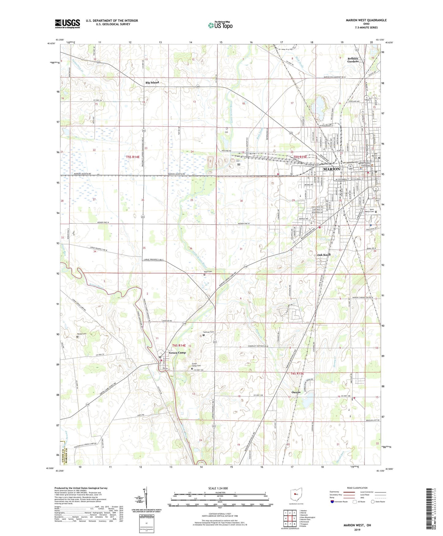
2019 topographic map quadrangle Marion West in the state of Ohio. Scale: 1:24000. Based on the newly updated USGS 7.5' US Topo map series, this map is in the following counties: Marion, Union. The map contains contour data, water features, and other items you are used to seeing on USGS maps, but also has updated roads and other features. This is the next generation of topographic maps. Printed on high-quality waterproof paper with UV fade-resistant inks.
Quads adjacent to this one:
West: New Bloomington
Northwest: Meeker
North: Morral
Northeast: Monnett
East: Marion East
Southeast: Waldo
South: Prospect
Southwest: Richwood
Contains the following named places: Baker Junior High School, Ballville Dam, Bellaire Gardens, Big Island, Big Island Post Office, Buckeye Trailer Park, Calvary United Methodist Church, Camp Owens, Church of Christ in Christian Union, Colonial Acres, Colonial Acres Elementary School, Country Club Hills, Deliverance Temple Church of Christ, Dennison Field, Eagle Creek, Eaglewood, Edison Middle School, Elgin High School, Elgin Junior High School, Emmanuel Baptist Church, Emmanuel Lutheran Church, Evangelical Church, First Church of God, First Church of the Nazarene, First Presbyterian Church, First United Church of Christ, First United Methodist Church, First Wesleyan Church, First Wesleyan Methodist Church, Fite Memorial Baptist Church, Fremont Reservoir, Glenwood Elementary School, Greater Saint Paul Church of God in Christ, Green Camp, Green Camp Cemetery, Green Camp Post Office, Green Camp Township Fire Department, Home Missionary Holiness Church, Honey Creek, Hords, House of Prayer Church, International Pentecostal Church of Christ, Kings Temple Apostolic Church, Lawrence Orchards, Lee Street Presbyterian Church, Lighthouse of Prayer Church, Lincoln Park, Little Scioto River, Longville, Longville Post Office, Maple Run, Maranatha Bible Baptist Church, Marion, Marion City Hall, Marion Country Club, Marion County, Marion County Courthouse, Marion County Law Library, Marion County Sheriff's Office, Marion Fire Department Station 1, Marion Fire Department Station 2, Marion General Hospital Heliport, Marion Police Department, Marion Township Fire Department Station 2, Mayes Community Temple, McKinley Park, Memorial Spiritualist Church, North Main Street Elementary School, Oak Knoll, Oak Knoll Baptist Chapel, Oak Street Elementary School, Oakland Mobile Home Park, Oakland School, OhioHealth Marion General Hospital, Old Marion Cemetery, Olney Avenue Elementary School, Owens, Owens Post Office, Pearl Street Elementary School, Pleasant Acres Mobile Home Park, Pleasant Elementary School, Pleasant High School, Pleasant Ridge Methodist Episcopal Church, Pleasant Township Fire Department, Prospect Street United Methodist Church, Quarry Estates, Quinn Chapel American Methodist Church, Rayl Cemetery, Reidel Cemetery, Rock Swale, Roosevelt Park, Rural / Metro Corporation, Ruth, Ruth Post Office, Saint Mary Catholic Church, Saint Marys Cemetery, Saint Marys School, Saint Pauls Episcopal Church, Salem United Church of Christ, Sawyer-Ludwig Park, Silver Street Elementary School, Stofcheck Ambulance Service, Sullivan Cemetery, Taft Middle School, Township of Big Island, Township of Green Camp, Township of Marion, Township of Pleasant, Trinity Baptist Church, Twin Oaks Mobile Home Park, Village of Green Camp, WDIF-FM (Marion), Wesley United Methodist Church, Willow Swamp, WMRN-AM (Marion), WMRN-FM (Marion), ZIP Codes: 43302, 43322