MyTopo
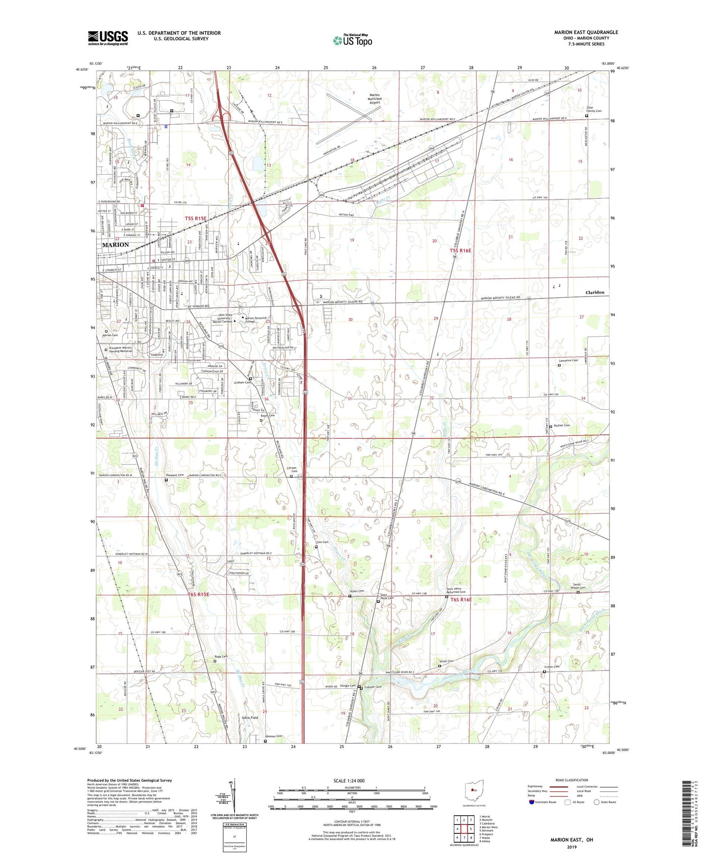
Marion East Ohio US Topo Map
Couldn't load pickup availability
2023 topographic map quadrangle Marion East in the state of Ohio. Scale: 1:24000. Based on the newly updated USGS 7.5' US Topo map series, this map is in the following counties: Marion. The map contains contour data, water features, and other items you are used to seeing on USGS maps, but also has updated roads and other features. This is the next generation of topographic maps. Printed on high-quality waterproof paper with UV fade-resistant inks.
Quads adjacent to this one:
West: Marion West
Northwest: Morral
North: Monnett
Northeast: Caledonia
East: Denmark
Southeast: Ashley
South: Waldo
Southwest: Prospect
This map covers the same area as the classic USGS quad with code o40083e1.
Contains the following named places: Air View Acres, Barks Cemetery, Boyer Cemetery, Canaan Cemetery, Canaan Church, Catholic High School, Central Christian Church, Chateau Ridge, Christ Missionary Baptist Church, City of Marion, Claridon Elementary School, Claridon Prairie, Collmer Cemetery, Community Medical Center Heliport, Community United Methodist Church, Crimm Cemetery, Crystal Lakes, Delco Plaza Shopping Center, Eber Baker Middle School, Epworth United Methodist Church, Fair Park Elementary School, Fairpark Baptist Church, First Church of Christ Scientist, First Church of the Brethren, Forest Lawn Presbyterian Church, Forum Shopping Center, Fountain Place Mobile Home Park, Garfield Park, George Washington Elementary School, Good Faith Baptist Church, Graham Cemetery, Grave Creek, Greenwood United Methodist Church, Harding High School, Harding Museum, Harry's Trailer Park, Highlands of Marion, Hunters Chase, Idleman Cemetery, Indian Mound Elementary School, Kensington Church of the Nazarene, Kings Mill Golf Course, Klingle Cemetery, Lawrence Cemetery, Locust Grove Church, Logan, Marion Allegheny Wesleyan Methodist Church, Marion Cemetery, Marion Christian Center, Marion Correctional Institution, Marion County Childrens Home, Marion County Fairgrounds, Marion Engineer Depot, Marion Fire Department Station 3, Marion Municipal Airport, Marion Plaza Shopping Center, Marion Post Office, Marion Public Library, Marion Technical College, Marion Township Fire Department Station 1, Mark Street Elementary School, Mark Street Second Wesleyan Church, Mar-O-Dell Golf Course, Med-Center Hospital, North Central Correctional Complex, Ohio State University, Pleasant Cemetery, Plotner Cemetery, President Warren Harding Memorial, Richland Township Hall, Riffle Creek, River Valley Elementary School, River Valley High School, Rupp Cemetery, Saint Johns Church, Saint Johns Reformed Cemetery, Saint Pauls Cemetery, Sayler Cemetery, Sheriffs Heliport, Smith - Witzel Cemetery, Smith Cemetery, Southern Estates, Southland Mall Shopping Center, Temple Israel, Timothy Church, Township of Claridon, Township of Richland, Tri-Rivers Career Center Joint Vocational School, Vernon Elementary School, Veterans Memorial Coliseum, Yorkshire Terrace, Ziller Family Cemetery, Zion Cemetery