MyTopo
Minford Ohio US Topo Map
Couldn't load pickup availability
Also explore the Minford Forest Service Topo of this same quad for updated USFS data
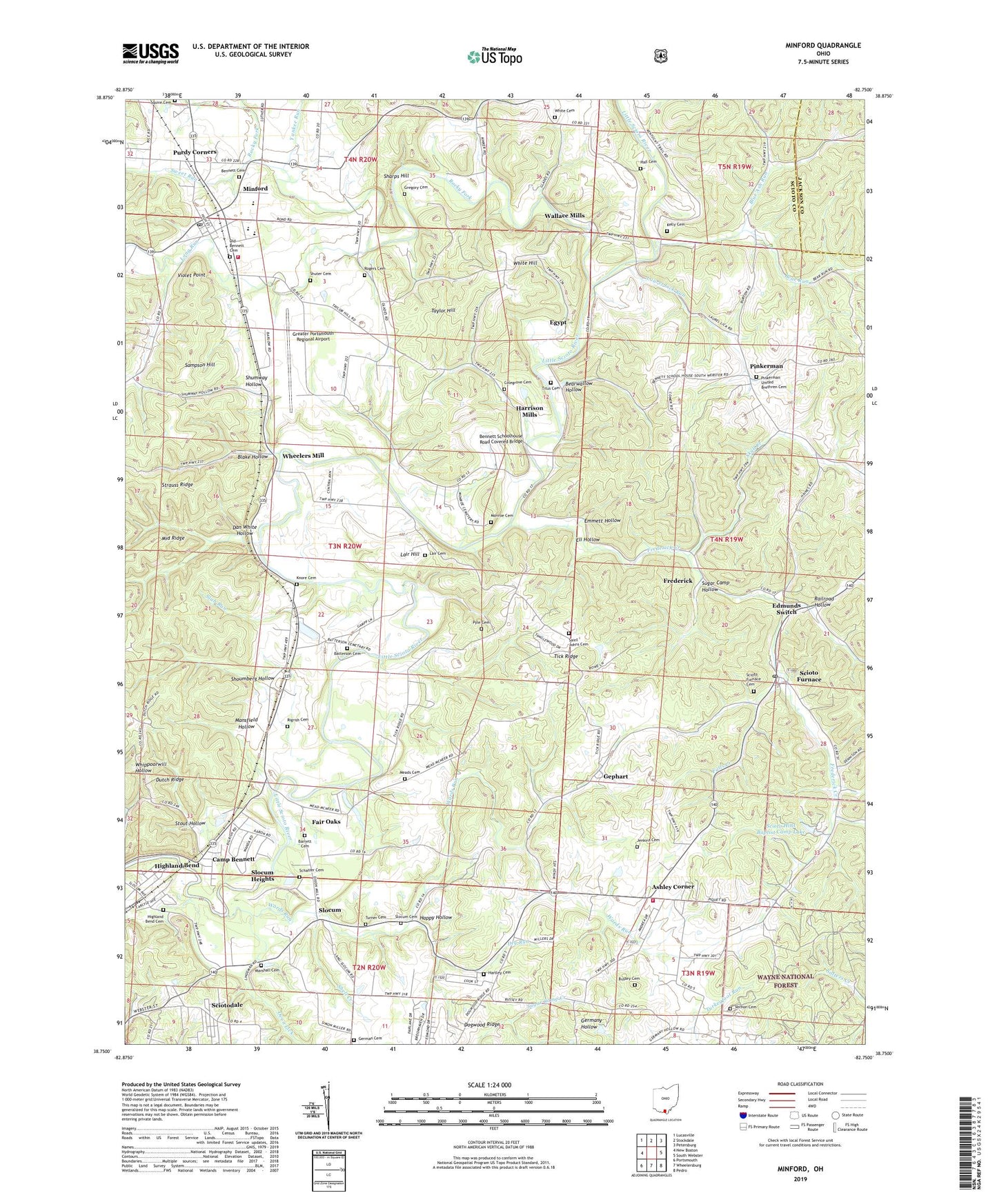
2023 topographic map quadrangle Minford in the state of Ohio. Scale: 1:24000. Based on the newly updated USGS 7.5' US Topo map series, this map is in the following counties: Scioto, Jackson. The map contains contour data, water features, and other items you are used to seeing on USGS maps, but also has updated roads and other features. This is the next generation of topographic maps. Printed on high-quality waterproof paper with UV fade-resistant inks.
Quads adjacent to this one:
West: New Boston
Northwest: Lucasville
North: Stockdale
Northeast: Petersburg
East: South Webster
Southeast: Pedro
South: Wheelersburg
Southwest: Portsmouth
This map covers the same area as the classic USGS quad with code o38082g7.
Contains the following named places: Ashley Corner, Barrett Cemetery, Batterson Cemetery, Bear Run, Bearwallow Hollow, Bennett Cemetery, Bennett Schoolhouse Road Covered Bridge, Blake Hollow, Bloom Church, Blue Ash Run, Bussey Cemetery, Bussey Hill Chapel, Camp Bennett, Colegrove Cemetery, Dan White Hollow, Dogwood Ridge, Dry Run, Edmunds School, Edmunds Switch, Egypt, Eli Hollow, Emmett Hollow, Fair Oaks, Falls Creek, Frederick, Frederick Church, Frederick Creek, Free Church, Fuhrmann Orchards, Gephart, German Cemetery, Glade School, Greater Portsmouth Regional Airport, Gregory Cemetery, Hall Cemetery, Happy Hollow, Happy Hours Addition, Harrison Church, Harrison Furnace Church, Harrison Furnace School, Harrison Mills, Harrison Mills Post Office, Hartley Cemetery, Hartley School, Higgins Run, Highland Bend, Highland Bend Cemetery, Jenkins Cemetery, Kelly Cemetery, Kettle School, Knore Airport, Knore Cemetery, Lair Cemetery, Lair Hill, Laurel Lick Run, Lily Chapel, Lindsay School, Long Run, Mansfield Hollow, Marshall Cemetery, Marshall School, Marshall Siding, Meads Cemetery, Meads Church, Meads School, Minford, Minford Census Designated Place, Minford Elementary School, Minford Emergency Ambulance Service, Minford High School, Minford Post Office, Minford Volunteer Fire Department, Monroe Cemetery, Old Bennett Cemetery, Oven Lick, Pinkerman, Pinkerman Post Office, Pinkerman United Brethren Cemetery, Porter Church, Porter Tabernacle, Purdy Corners, Pyle Cemetery, Railroad Hollow, Rigrish Addition, Rigrish Cemetery, Riverview Church, Rocky Fork, Rogers Cemetery, Saint Johns Cemetery, Sampson Hill, Schaffer Cemetery, Scioto Ambulance District Squad 6, Scioto Furnace, Scioto Furnace Cemetery, Scioto Furnace Post Office, Scioto Hills Baptist Camp Lake, Scioto Hills Baptist Camp Lake Dam, Sciotodale, Sciotodale Census Designated Place, Sciotodale Freewill Baptist Church, Sharps Hill, Shell Creek, Shoumberg Hollow, Shumway Hollow, Shuter Cemetery, Skull Creek, Slab Run, Slocum, Slocum Cemetery, Slocum Heights, Slocum Station Church, Squire Cemetery, Stockhams School, Stout Hollow, Strauss Ridge, Sugar Camp Hollow, Sunshine Church, Sunshine School, Sweet Run, Taylor Hill, Tick Ridge, Tick Ridge Church, Tick Ridge School, Titus Cemetery, Township of Harrison, Tri-Township Tabernacle, Turner Cemetery, Union Church, Vernon Cemetery, Vernon School, Vernon Township Fire Station 2, Violet Point, Waite School, Waits Church, Wallace Mills, Wallace Mills Post Office, Wards Run, Wheelers Mill, White Cemetery, White Hill, Whites School, Yankee Run