MyTopo
Springboro Ohio US Topo Map
Couldn't load pickup availability
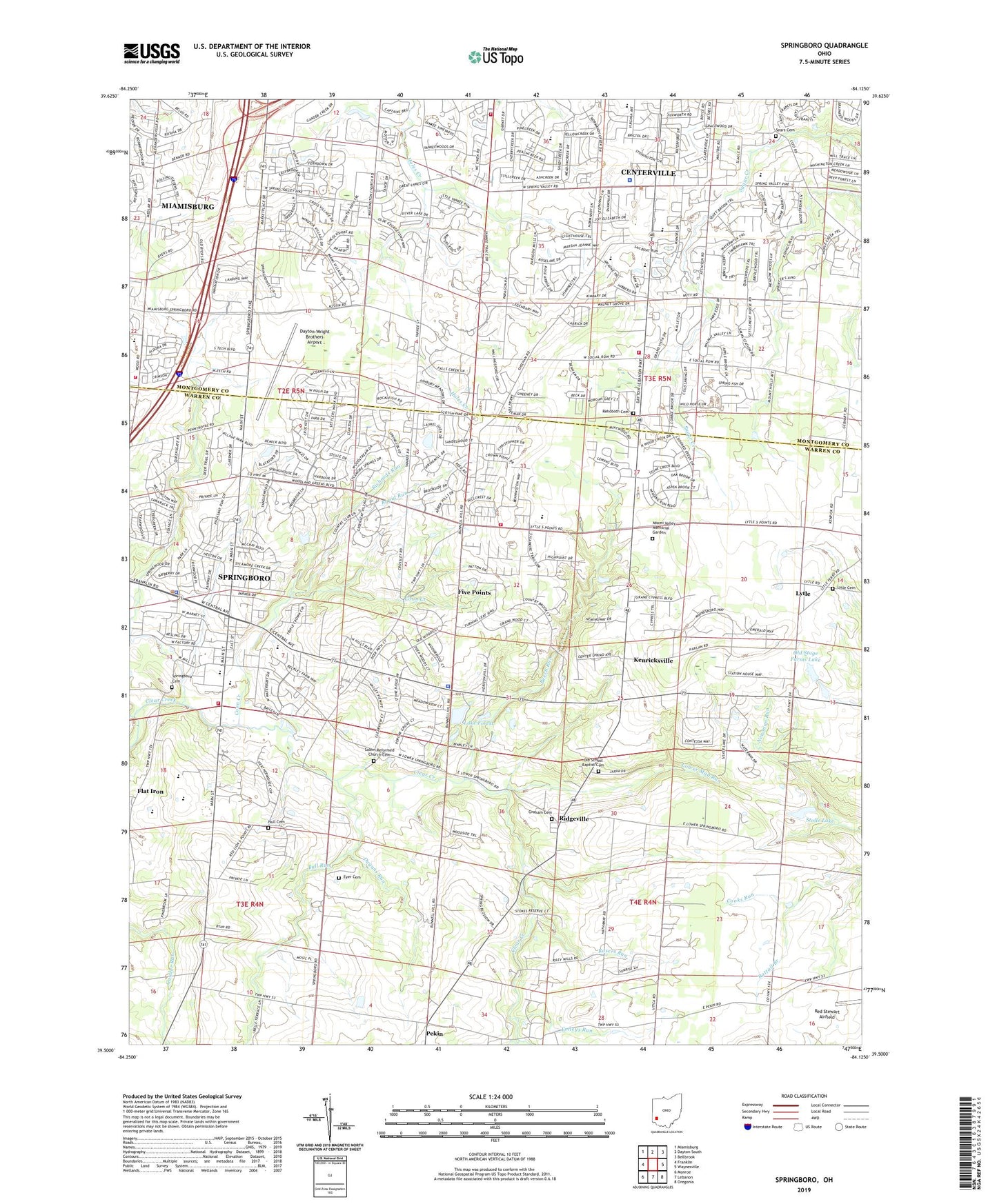
2023 topographic map quadrangle Springboro in the state of Ohio. Scale: 1:24000. Based on the newly updated USGS 7.5' US Topo map series, this map is in the following counties: Warren, Montgomery. The map contains contour data, water features, and other items you are used to seeing on USGS maps, but also has updated roads and other features. This is the next generation of topographic maps. Printed on high-quality waterproof paper with UV fade-resistant inks.
Quads adjacent to this one:
West: Franklin
Northwest: Miamisburg
North: Dayton South
Northeast: Bellbrook
East: Waynesville
Southeast: Oregonia
South: Lebanon
Southwest: Monroe
This map covers the same area as the classic USGS quad with code o39084e2.
Contains the following named places: Beech Run, Benjamin Archer Park, Buckeye School, Bull Run, Centerville Place Shopping Center, Centerville Police Department, Centerville Square Shopping Center, City of Springboro, Clear Creek Township Police Department, Clearcreek Elementary School, Clearcreek Fire District Station 21, Clearcreek Fire District Station 22, Concept Park, Cooks Run, Coon Creek, Dayton-Wright Brothers Airport, Dugans Run, Edgewood, Emleys Run, Eyer Cemetery, Five Points, Five Points Census Designated Place, Five Points Elementary School, Flat Iron, Friends Cemetery, Galbreath Metro Office Park, Graham Cemetery, Heritage Hills Memory Gardens, Hicksite Quaker Cemetery, Hidden Valley Fruit Farm, Horizon Pointe Church, Jonathan Wright Elementary School, Kenricksville, Kessling Park, Kitchener, Lair Park, Lake Forest, Lake Forest Dam, Lower Mad Run, Lytle, Lytle Cemetery, Lytle Methodist Church, Manor, Miami Valley Fire District Station 51, Miami Valley Memorial Garden, Null Cemetery, Nutt Woods Park, Oakwood Village, Old School Baptist Cemetery, Old Stage Farms Lake, Old Stage Farms Lake Dam, Pekin, Quail Run Park, Rapid Run, Rehoboth Cemetery, Richards Run, Ridgeville, Rileys Run, Rosers Run, Rosewood Park, Royal Springs Estates, Saint Leonards College, Salem Reformed Church Cemetery, School Number 1, School Number 10, School Number 5, School Number 6, School Number 7, School Number 8, Sears Cemetery, Skyland Airport, Spring Valley Academy, Springboro, Springboro Cemetery, Springboro High School, Springboro Junior High School, Springboro Plaza Shopping Center, Springboro Police Department, Stolle Lake, Stolle Lake Dam, Stringtown Park, Sugar Valley Park, Sycamore Creek Country Club, Sycamore Hospital Heliport, Tamarack Hills, Township of Clear Creek, Venable, W O Cline Elementary School, Waldruhe Park, Washington Township Fire Department, Washington Township Fire Department Station 43, Washington Township Fire Headquarters and Training Center, Washington Township Public Library, Watkins Glen Park, Weller Elementary School, Western Park, ZIP Codes: 45066, 45458