MyTopo
Piedmont Ohio US Topo Map
Couldn't load pickup availability
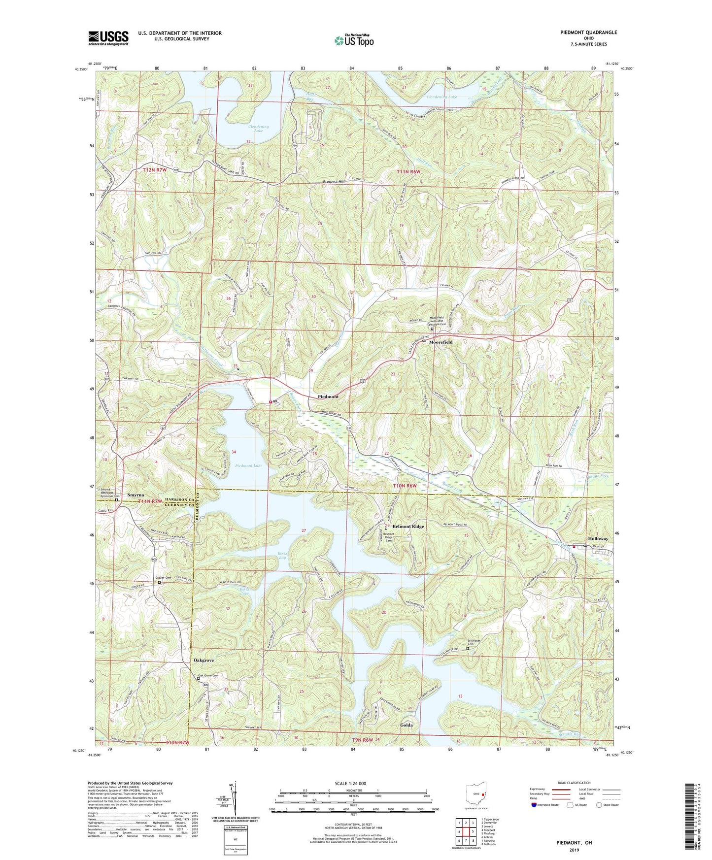
2023 topographic map quadrangle Piedmont in the state of Ohio. Scale: 1:24000. Based on the newly updated USGS 7.5' US Topo map series, this map is in the following counties: Harrison, Belmont, Guernsey. The map contains contour data, water features, and other items you are used to seeing on USGS maps, but also has updated roads and other features. This is the next generation of topographic maps. Printed on high-quality waterproof paper with UV fade-resistant inks.
Quads adjacent to this one:
West: Freeport
Northwest: Tippecanoe
North: Deersville
Northeast: Jewett
East: Flushing
Southeast: Bethesda
South: Fairview
Southwest: Antrim
This map covers the same area as the classic USGS quad with code o40081b2.
Contains the following named places: Belmont Ridge, Belmont Ridge Cemetery, Belmont Ridge Methodist Episcopal Church, Boggs Fork, Briar Hill Club, Briar Hill Farm, Camp Presmont, Clendening Lake, East Piedmont, Elk Run, Essex Bay, Essex Cove, Golda, Golda Post Office, Goodrich Cottage Area, Harrison County Club, Hazelwood Hill Club, Hidden Ledges Cottage Area, Hilltop Cottage Area, Holloway, Holloway Elementary School, Holloway Post Office, Holloway Volunteer Fire Department Station 26, Huff Bay, Huff Run, Indian Run, Loghaven, Moorefield, Moorefield Methodist Episcopal Cemetery, Moorefield Post Office, Moorefield Township Fire Department, Muskie Bay, Oak Grove Cemetery, Oak Grove Methodist Episcopal Church, Oakgrove, Oakgrove Post Office, Piedmont, Piedmont Dam, Piedmont Lake, Piedmont Lake Marina, Piedmont Post Office, Plum Run, Prospect Hill, Quaker Cemetery, Reynolds Road Cottage Area, Rush Run, Shanty Bay, Sixmile Run, Smyrna, Smyrna Methodist Episcopal Cemetery, Smyrna Post Office, Stillwater Cemetery, Township of Flushing, Township of Moorefield, Trail Run, Village of Holloway, ZIP Codes: 43983, 43985