MyTopo
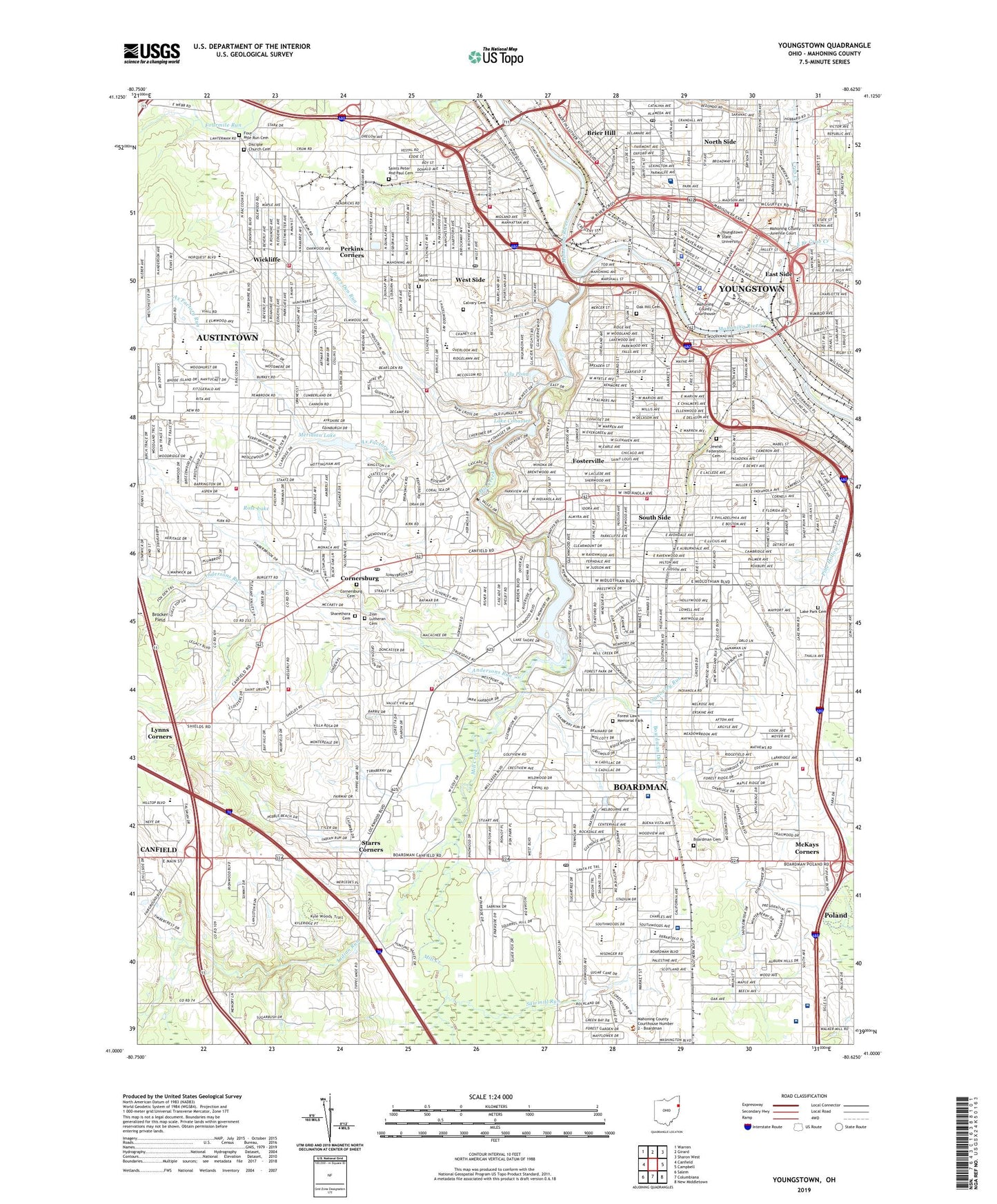
Youngstown Ohio US Topo Map
Couldn't load pickup availability
2023 topographic map quadrangle Youngstown in the state of Ohio. Scale: 1:24000. Based on the newly updated USGS 7.5' US Topo map series, this map is in the following counties: Mahoning. The map contains contour data, water features, and other items you are used to seeing on USGS maps, but also has updated roads and other features. This is the next generation of topographic maps. Printed on high-quality waterproof paper with UV fade-resistant inks.
Quads adjacent to this one:
West: Canfield
Northwest: Warren
North: Girard
Northeast: Sharon West
East: Campbell
Southeast: New Middletown
South: Columbiana
Southwest: Salem
This map covers the same area as the classic USGS quad with code o41080a6.
Contains the following named places: Adams Elementary School, Akron Children's Hospital Beeghly Campus, Andersons Run, Arlington Avenue Historic District, Austintown Census Designated Place, Ax Factory Run, Bancroft Park, Bancroft School, Bears Den Run, Beeghly Center, Bennett Elementary School, Boardman, Boardman Cemetery, Boardman Census Designated Place, Boardman Ditch, Boardman High School, Boardman Junior High School, Boardman Park, Boardman Plaza Shopping Center, Boardman Post Office, Boardman Rural Station Post Office, Boardman Township Hall, Boris Field, Boulevard Shops Shopping Center, Brier Hill, Brier Hill Park, Brier Hill Post Office, Butler Institute of American Art, Calvary Cemetery, Cardinal Mooney High School, Central Mobile Home Park, Chaney High School, Charles Ditch, Chicago Park, Christs Mission Camp, City of Youngstown, Cleveland Elementary School, Colonial Plaza, Cornersburg, Cornersburg Cemetery, Cornersburg Plaza Shopping Center, Cornersburg Post Office, Covington School, Crab Creek, Cranberry Run, Crandall Park, Crims Corners Shopping Plaza, Davis Elementary School, Delason Park, Disciple Church Cemetery, East Branch Crab Creek, East Side, Elm School, Evans Field, Fitch High School, Flint Hill, Forest Lawn Memorial Park, Fosterville, Fosterville Branch Library, Fosterville Park, Four Mile Run Christian Church Cemetery, Fourmile Run, Frank Ohl Middle School, Garfield School, Gibson Park, Greenbriar Rehabilitation Hospital, Handworks Corners, Harrison Elementary School, Harrison Field, Hayes Junior High School, Hell Street School, Hillman Elementary School, Hills Plaza Shopping Center, Hilltop Elementary School, Holy Name School, Homestead Park, Huntington Woods Mall Shopping Center, I-680 Plaza Shopping Center, Idora Park, Immaculate Conception School, Immaculate Heart of Mary School, Indian Run, Jefferson Elementary School, Jewish Federation Cemetery, Kirkmere Elementary School, Kochis Park, Kyle Park, Kyles Corner Post Office, Kyles Corners, Lake Cohasset, Lake Cohasset Dam, Lake Glacier, Lake Glacier Dam, Lake Macachee, Lake Park Cemetery, Lanterman Mill, Leonard Kirtz School, Lily Pond, Lincoln Elementary School, Lynn Kirk Elementary School, Lynn Street School, Lynns Corners, Madison Elementary School, Mahoning County Courthouse, Mahoning Plaza Shopping Center, Market Street Elementary School, Martin Mobile Home Park, Mattews Square Plaza Shopping Cnetr, McDonough Museum of Art, McGuffy Plaza, McKays Corners, McKinley School, Meridian Lake, Mill Creek, Mill Creek Park, Monroe School, Mount Calvary Christian Academy of Higher Learning, Mud School, Newport Lake, Newport Lake Dam, Newport Square Shopping Center, North Branch Library, North Side, North Side Post Office, Northside and Tod Childrens Hospital Heliport, Oak Hill Cemetery, Oak Park, Optimist Club Camp, Osteopathic Hospital, Parkside Place Shopping Center, Parmelee Park, Pelican Park Plaza Shopping Center, Pemberton Park, Perkins Corners, Pine Hollow Park, Poland West Plaza Shopping Center, Presidential Square Shopping Center, Princeton Elementary School, Rayen School, Receiving Hospital, Reuben McMillian Public Library, Robinwood Lane Elementary School, Rock Island Lake, Rock Island Lake Dam, Rogers Volney Junior High School, Rose Lake, Saint Anns School, Saint Anthony School, Saint Brendans School, Saint Casimirs School, Saint Charles School, Saint Christines School, Saint Dominics School, Saint Elizabeth Youngstown Hospital, Saint Josephs School, Saint Marys Cemetery, Saint Matthias School, Saint Patrick School, Saint Patricks School, Saint Stephen of Hungary School, Saints Peter and Paul Cemetery, Sawmill Run, Schenley Park, Select Specialty Hospital - Youngstown, Sharethora Cemetery, Sheridan Elementary School, Sheridan Park, South High School, South Side, South Side Park, Southern Park Mall Shopping Center, Southside Medical Center, Stadium Drive School, Stambaugh Auditorium, Stambaugh Camp, Stambaugh Park, Stambaugh Stadium, Stambaugh Transitional School, Starrs Corners, Taft Elementary School, Taft Park, Teri-Mar Plaza Shopping Center, The Surgical Hospital at Southwoods, Thorn Hill Station, Tippecanoe Country Club, Township of Boardman, Ulysses S Grant Elementary School, United Methodist Community Center, Uptown Shopping Center, Urusline High School, Vibra Hospital of Mahoning Valley, Volney Rogers Field, Washington School, Watson Elementary School, WBBG-FM (Youngstown), WBBW-AM (Youngstown), Wedgewood Center Shopping Center, Wedgewood Plaza Shopping Center, West Boulevard Elementary School, West Junior High School, West Side, West Side Post Office, Western Fair Plaza Shopping Center, Westgate Shopping Center, Westside Branch Library, WFMJ-TV (Youngstown), WHOT-AM (Youngstown), WHOT-FM (Youngstown), Wick Avenue Historic District, Wick Park, Wick Park Historic District, Wickliffe, Wickliffe School, William F Maag Library, Williamson Elementary School, Williamston, Wilson High School, WKBN-FM (Youngstown), WKBN-TV (Youngstown), WYSU-FM (Youngstown), WYTN-FM (Youngstown), WYTV-TV (Youngstown), Youngstown, Youngstown Post Office, Youngstown State University, Zion Lutheran Cemetery, ZIP Codes: 44502, 44503, 44504, 44506, 44507, 44509, 44510, 44511, 44512


