MyTopo
Sharon West Pennsylvania US Topo Map
Couldn't load pickup availability
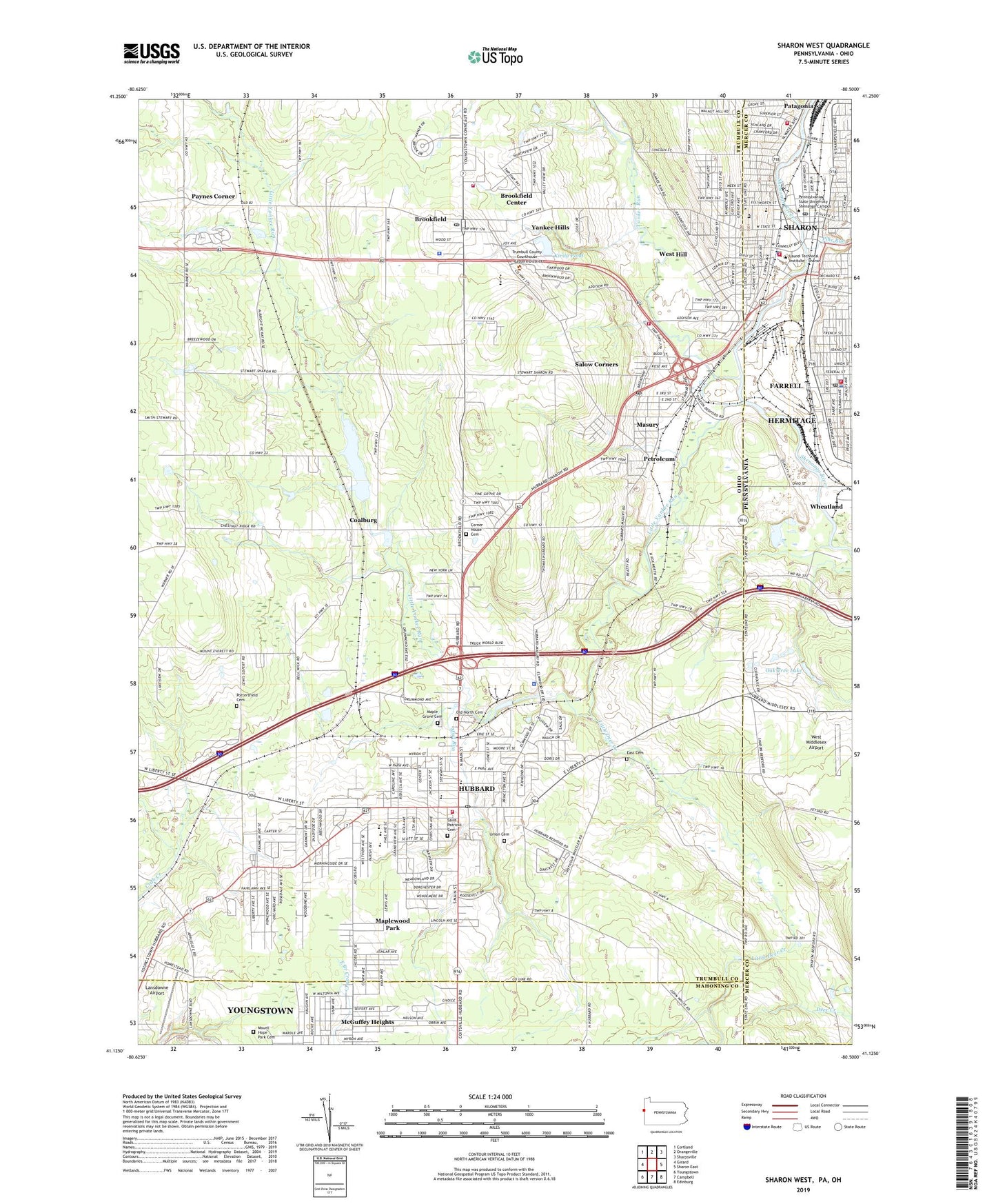
2023 topographic map quadrangle Sharon West in the states of Ohio, Pennsylvania. Scale: 1:24000. Based on the newly updated USGS 7.5' US Topo map series, this map is in the following counties: Mercer, Trumbull, Mahoning, Lawrence. The map contains contour data, water features, and other items you are used to seeing on USGS maps, but also has updated roads and other features. This is the next generation of topographic maps. Printed on high-quality waterproof paper with UV fade-resistant inks.
Quads adjacent to this one:
West: Girard
Northwest: Cortland
North: Orangeville
Northeast: Sharpsville
East: Sharon East
Southeast: Edinburg
South: Campbell
Southwest: Youngstown
This map covers the same area as the classic USGS quad with code o41080b5.
Contains the following named places: Addison Elementary School, Alpha and Omega First Baptist Church, Bailey Park, Baldine Plaza Shopping Center, Bentley, Brookfield, Brookfield Acres, Brookfield Air Force Station, Brookfield Airpark, Brookfield Center, Brookfield Center Census Designated Place, Brookfield Center Historic District, Brookfield Gardens, Brookfield High School, Brookfield Junior High School, Brookfield Police Department, Brookfield Post Office, Brookfield Station, Brookfield Township Fire Department Station 18, Brookfield Township Fire Department Station 2, Brookfield Village Green, Calvary Baptist Church, Central Christian Church, Christian Revival Center, City of Hubbard, Coalburg, Coalburg Lake, Coalburg Lake Dam, Coalburg Post Office, Coalburg United Methodist Church, Corner House Cemetery, Corner House Church, Curtis Elementary School, Deer Creek Golf Course, Donnybrook Golf Course, Doughton, Doughton Country Club, E T B C Apostolic Church, East Cemetery, Farrell Police Department, Farrell Post Office, Farrell Volunteer Fire Department Station 98, First Assembly of God Church, First Baptist Church of Hubbard, First United Methodist Church of Hubbard, Frist Presbyterian Church of Hubbard, Germantown, Grace Lutheran Church, Harding Park, Hells Corners, House of Jacob, Hubbard, Hubbard Country Club, Hubbard Fire Department, Hubbard High School, Hubbard Plaza Shopping Center, Hubbard Post Office, Hubbard Public Library, Hubbard Township Police Department, Hubbard Wastewater Pollution Control Facility, Jones Playground, Kansas Corners, Kirila Heliport, Kirila Pond, Kirila Pond Dam, Lansdowne Airport, Laurel Park, Little Deer Creek, Little Yankee Run, Maple Grove Cemetery, Maplewood Park, Maplewood Park Census Designated Place, Masury, Masury Census Designated Place, Masury Post Office, Maybrook Mall Shopping Center, McGuffey Heights, Mount Hope Park Cemetery, Mount Vernon Baptist Church, Mud Run, Oak Tree Dam, Oak Tree Lake, Old North Cemetery, Patagonia, Patagonia Volunteer Fire Department Station 86 - 2, Paynes Corner, Paynes Corners Post Office, Petroleum, Pilgrim Rest United Holy Church of America, Pine Run, Portersfield Cemetery, Redeemer Christian Center, Reed Middle School, Reeds Chapel African Methodist Episcopal Church, Rising Star Baptist Church, Roosevelt Elementary School, Sacred Heart of Jesus School, Saint Patricks Catholic Church, Saint Patricks Cemetery, Saint Patricks School, Saint Thomas African Methodist Episcopal Zion Church, Salow Corners, Second Christian Church, Sharon City Police Department, Sharon Fire Department Station 83, Sharon Post Office, Slope Church, Stevenson Elementary School, Stoneybrook Village Mobile Home Park, T W Stolport, Township of Brookfield, Township of Hubbard, Tried Stone Baptist Church, Triumph the Church and Kingdom of God in Christ, Union Cemetery, Veteran Square, Vienna Tree Farm, Walnut Hill, West Hill, West Hill Census Designated Place, West Hill Elementary School, West Middlesex Airport, WGBU-AM (Farrell), WMGZ-FM (Sharpsville), Yankee Hills, Yankee Run, Yankee Run Country Club, ZIP Codes: 44403, 44425, 44438, 44505