MyTopo
Fort Sill Oklahoma US Topo Map
Couldn't load pickup availability
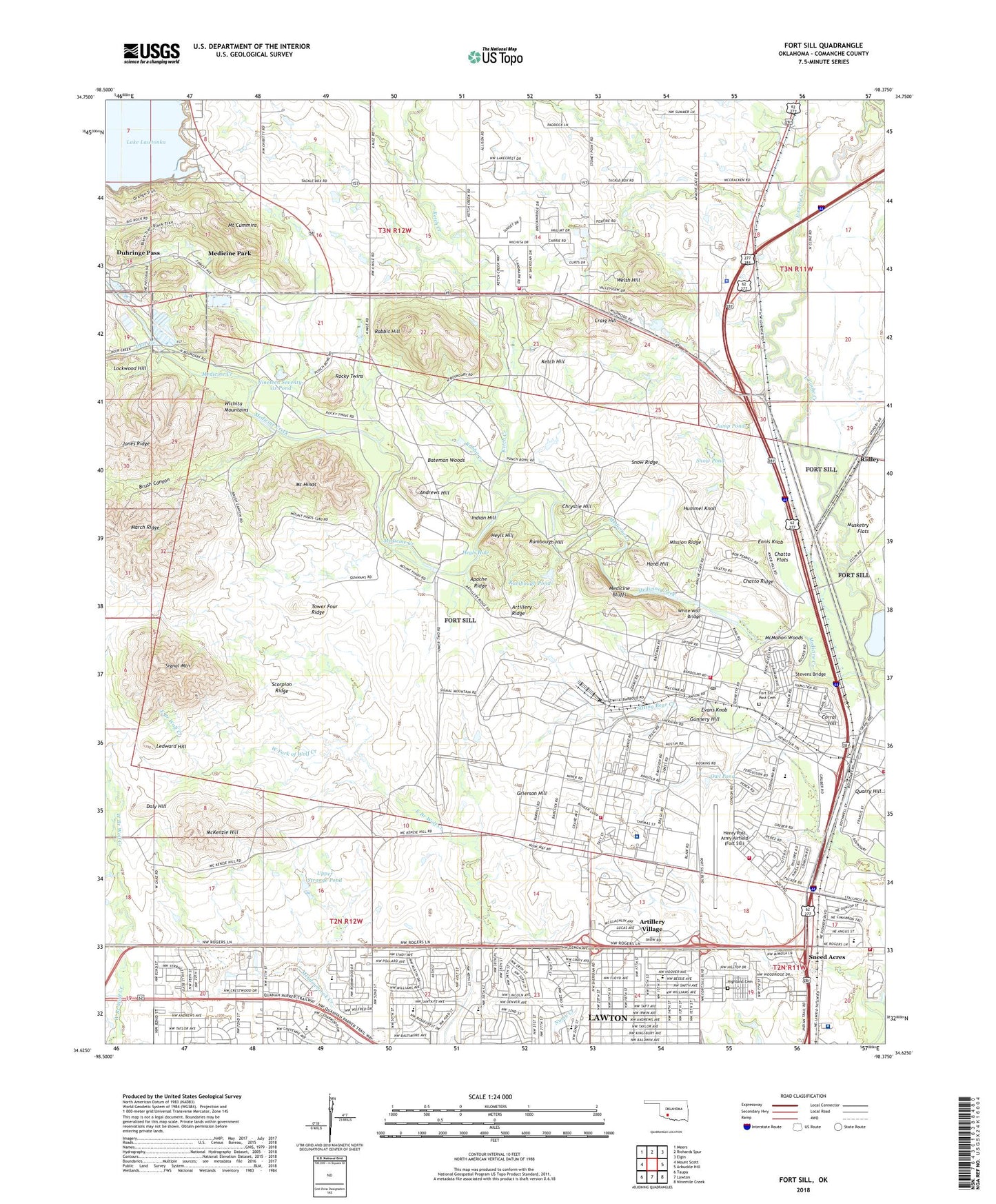
2022 topographic map quadrangle Fort Sill in the state of Oklahoma. Scale: 1:24000. Based on the newly updated USGS 7.5' US Topo map series, this map is in the following counties: Comanche. The map contains contour data, water features, and other items you are used to seeing on USGS maps, but also has updated roads and other features. This is the next generation of topographic maps. Printed on high-quality waterproof paper with UV fade-resistant inks.
Quads adjacent to this one:
West: Mount Scott
Northwest: Meers
North: Richards Spur
Northeast: Elgin
East: Arbuckle Hill
Southeast: Ninemile Creek
South: Lawton
Southwest: Taupa
This map covers the same area as the classic USGS quad with code o34098f4.
Contains the following named places: Ambrosia Park, Andrews Hill, Apache Ridge, Artillery Bowl, Artillery Ridge, Artillery Village, Bateman Woods, Beef Creek, Brush Canyon, Butch Suttle Park, Butner Field, Cache Road Church, Cedar Grove Golf Course, Cedar Lakes Golf Course, Charlie Ray Park, Chatto Crossing, Chatto Flats, Chatto Ridge, Christ Gospel Church, Chrystie Hill, Comanche Church, Comanche County, Comanche Indian Mission, Comanche Tribal Complex, Comanche Tribal Police Department, Corral Crossing, Corral Hill, Craig Hill, Crosby Park Elementary School, Daly Hill, Deer Creek, Diamond Brigade Chapel, Duhringe Pass, Ennis Knob, Estelle Jones Park, Evans Knob, First Church of God, First World Outreach Church, Flipper's Ditch, Fort Sill Division, Fort Sill Fire Department Station 1, Fort Sill Fire Department Station 2, Fort Sill Fire Department Station 3, Fort Sill Fire Department Station 4, Fort Sill Museum, Fort Sill National Historic Site, Fort Sill Post Cemetery, Fort Sill Post Office, Four Mile Crossing, Francis Curb Park, Francis Curt Park, Geronimo Pond, Geronimo Road Elementary School, Gray-Warr Park, Grenade Crossing, Grierson Hill, Grierson Hill Church, Gunnery Hill, Hand Hill, Harold Park, Hartell Boulevard Chapel, Henry Post Army Airfield (Fort Sill), Heyls Hill, Heyls Hole, Highland Cemetery, Holy Cross Church, Hugh Bish Elementary School, Hummel Knoll, Hunter Hills Park, Indian Agency Cemetery, Indian Hill, Jack Laughter Park, Jackson Elementary School, James A Manning State Fish Hatchery, James Arthur Manning State Fish Hatchery, Jefferson School, Jones Ridge, Jump Pond, Ketch Creek, Ketch Hill, Kuntz School, Landing Strip Fifteen, Lawton Fire Department Station 3, Lawton Heights Church-Nazarene, Lawton Heights United Methodist Church, Lawton Indian Hospital, Learning Tree Academy, Ledward Hill, Lee School, Legion Park, Legion Pond, Lime Creek, Lockwood Hill, M. Songbird Management Area, March Ridge, Martha Songbird Wildlife Management Area, McKenzie Hill, McMahon Woods, Medicine Bluffs, Medicine Creek, Medicine Creek Park, Mission Ridge, Mission Village Church, Mount Cummins, Mount Hinds, Mount Scott Comache Mission, Musketry Flats, New Post Chapel, Nineteen Seventy-six Pond, Northside Southern Baptist Church, Nye Library, Old Post Chapel, Old Post Church, Owl Pond, Panther Park, Pat Henry Elementary School, Peachtree Crossing, Petarsy Indian Mission, Pioneer Park Elementary School, Pollard Avenue Church, Post Golf Course, Prichard Field, Primitive Church, Quinette Crossing, Quinette Picnic Area, Rabbit Creek, Rabbit Hill, Rabbit Hill Airfield, Reynolds Army Community Hospital, Ridgecrest Elementary School, Ridley, Rocket Pond, Rocky Twins, Rogers Lane Church, Rucker Park, Rumbough Hill, Rumbough Pond, Saint Barbara School, Scorpion Ridge, Sheridan Road Chapel, Sheridan Road Elementary School, Signal Mountain, Sneed Acres, Snow Hall, Snow Pond, Snow Ridge, South Church, Stephens Park, Stevens Bridge, Swinney Elementary School, Taft School, Terrace Hills Park, Tiapiha Park, Tower Four Ridge, Town of Medicine Park, Township of Lawton, Upper Strange Pond, Welsh Hill, Westwood Church, White Wolf Bridge, Wichita Mountain Estates Fire Department, ZIP Codes: 73503, 73557