MyTopo
Kiefer SW Oklahoma US Topo Map
Couldn't load pickup availability
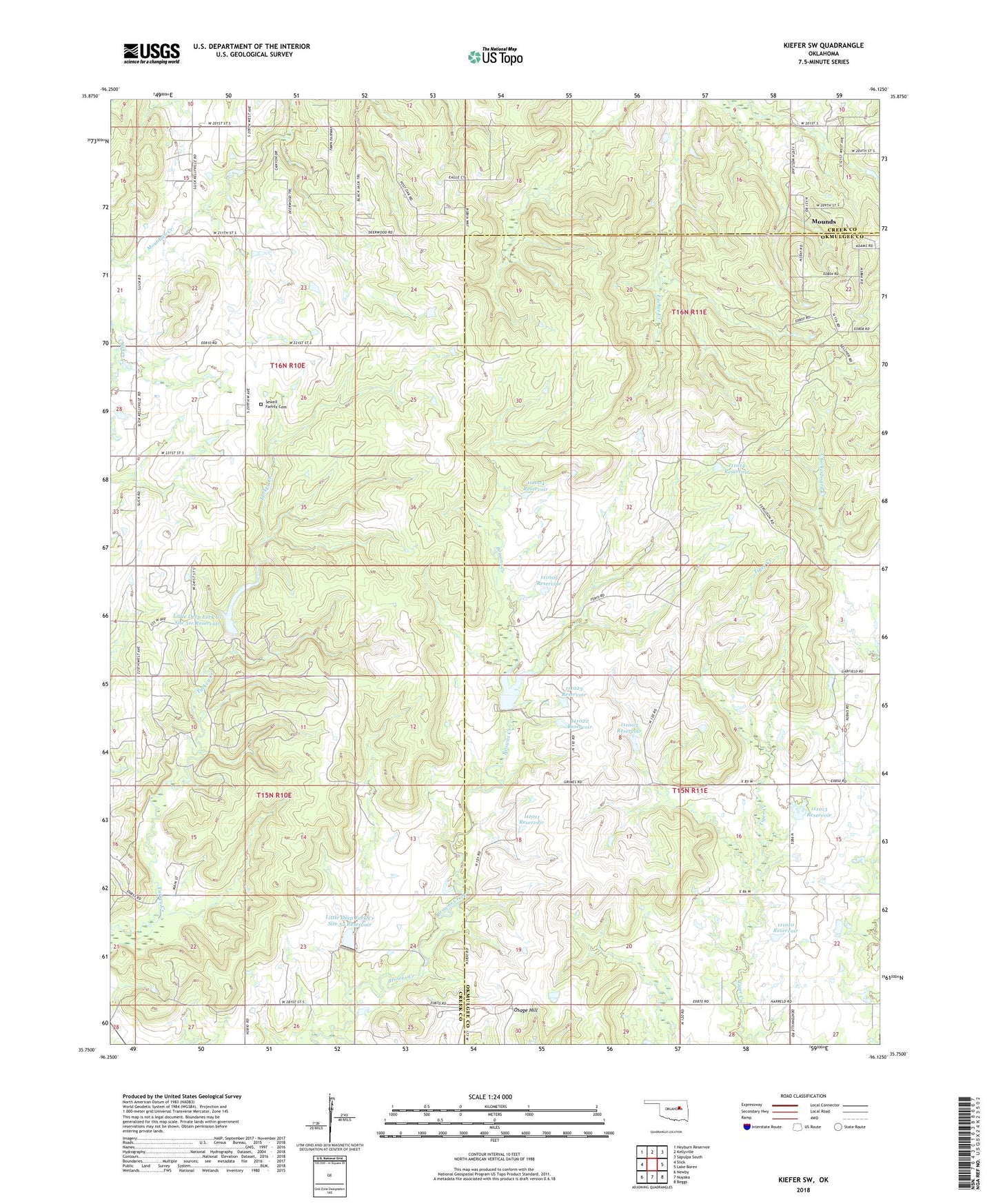
2018 topographic map quadrangle Kiefer SW in the state of Oklahoma. Scale: 1:24000. Based on the newly updated USGS 7.5' US Topo map series, this map is in the following counties: Creek, Okmulgee. The map contains contour data, water features, and other items you are used to seeing on USGS maps, but also has updated roads and other features. This is the next generation of topographic maps. Printed on high-quality waterproof paper with UV fade-resistant inks.
Quads adjacent to this one:
West: Slick
Northwest: Heyburn Reservoir
North: Kellyville
Northeast: Sapulpa South
East: Lake Boren
Southeast: Beggs
South: Nuyaka
Southwest: Newby
Contains the following named places: Flying H Ranch, Kellyville-Slick Division, Little Deep Fork Creek Site 51r Dam, Little Deep Fork Creek Site 51r Reservoir, Little Deep Fork Creek Site 52 Dam, Little Deep Fork Creek Site 52 Reservoir, Little Deep Fork Creek Site 54 Dam, Little Deep Fork Creek Site 54 Reservoir, Oknoname 111003 Dam, Oknoname 111003 Reservoir, Oknoname 111004 Dam, Oknoname 111004 Reservoir, Oknoname 111005 Dam, Oknoname 111005 Reservoir, Oknoname 111010 Dam, Oknoname 111010 Reservoir, Oknoname 111011 Dam, Oknoname 111011 Reservoir, Oknoname 111013 Dam, Oknoname 111013 Reservoir, Oknoname 111014 Dam, Oknoname 111014 Reservoir, Oknoname 111022 Dam, Oknoname 111022 Reservoir, Oknoname 111023 Dam, Oknoname 111023 Reservoir, Osage Hill, Sewell Family Cemetery, Upper Muddy Boggy Site Number 22 Dam, Upper Muddy Boggy Site Number 22 Reservoir