MyTopo
Sand Springs Oklahoma US Topo Map
Couldn't load pickup availability
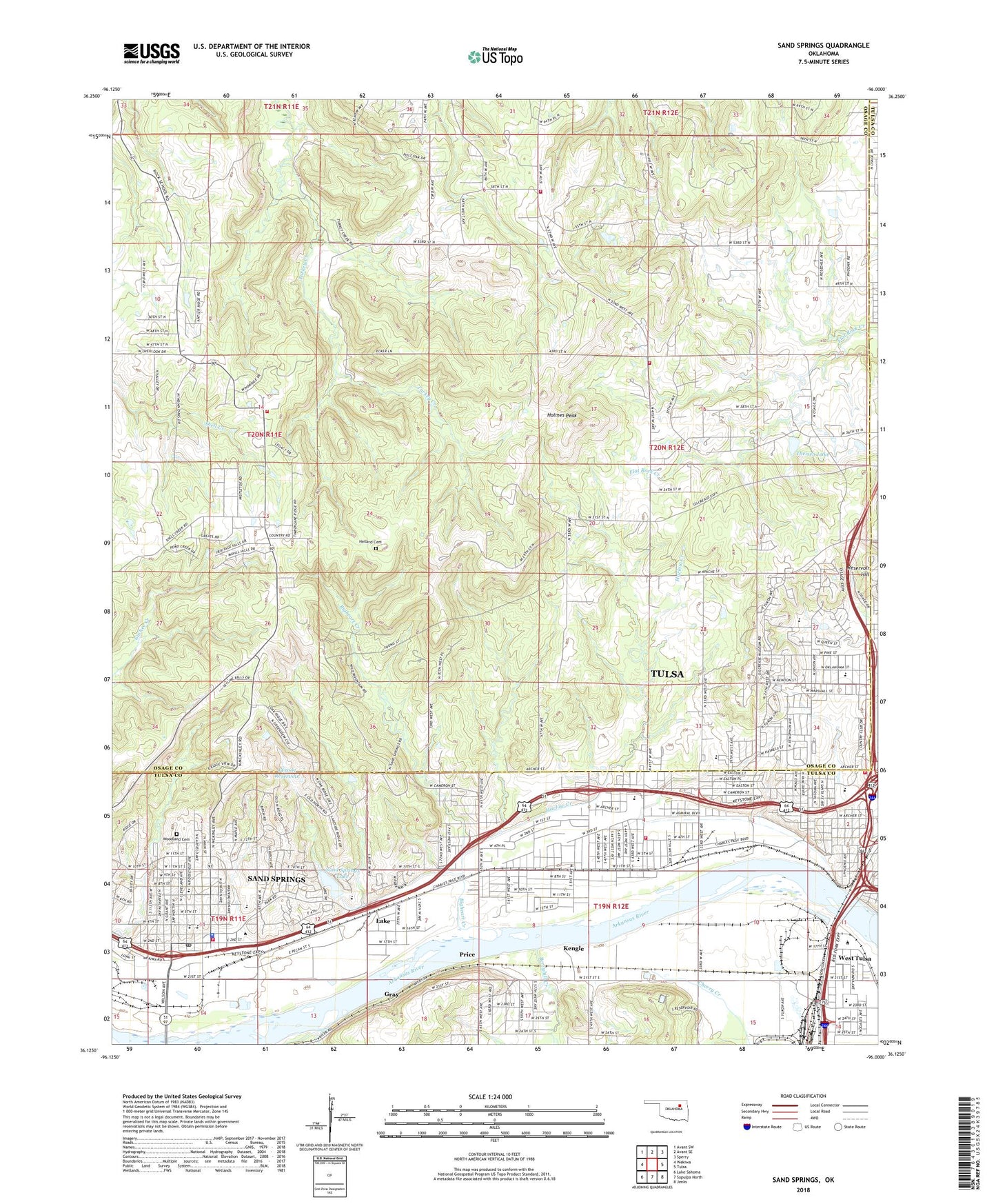
2022 topographic map quadrangle Sand Springs in the state of Oklahoma. Scale: 1:24000. Based on the newly updated USGS 7.5' US Topo map series, this map is in the following counties: Osage, Tulsa. The map contains contour data, water features, and other items you are used to seeing on USGS maps, but also has updated roads and other features. This is the next generation of topographic maps. Printed on high-quality waterproof paper with UV fade-resistant inks.
Quads adjacent to this one:
West: Wekiwa
Northwest: Avant SW
North: Avant SE
Northeast: Sperry
East: Tulsa
Southeast: Jenks
South: Sapulpa North
Southwest: Lake Sahoma
This map covers the same area as the classic USGS quad with code o36096b1.
Contains the following named places: 49th Street Hill Church, 74126, 74127, Academy Central Elementary School, American Baptist Churches, Berryhill Creek, Bigheart Creek, Black Dog Fire Department, Booker T Washington School, Broadway Baptist Church, Calvary Heights Temple Church, Calvary Temple Assembly of God, Centennial Baptist Church, Central 9th Grade Center, Central Elementary School, Central High School, Chandler Park, Charles Page High School, Chouteau Elementary School, Christ Gospel Church, Church of God, Church of God-Anderson Independent, City of Sand Springs Fire Department Station 1, Copernaum Missionary Baptist Church, Douglas Park, Downtown Airpark, Easton Heights Baptist Church, Eugene Field Elementary School, First Assembly of God, First Baptist Church of Sand Springs, First Christian Church, First Indian Baptist Church, First Presbyterian Church, Garfield Elementary School, Gilcrease Hills, Gilcrease Hills Baptist Church, Glenwood Baptist Church, Glenwood Full Gospel Church, Grace United Methodist Church, Gray, Greater Visions Church, Guiding Light Tabernacle Church, Hagler Memorial United Methodist Church, Halestation Pentecostal Church, Harlow Creek, Harris Shopping Center, Harrison Memorial United Methodist Church, Hellard Cemetery, Heritage Baptist Church, Holmes Peak, Howard Park, Immaculate Conception Church, Immaculate Conception School, KBEZ-FM (Tulsa), KCFO-AM (Tulsa), Kengle, KGTO-AM (Tulsa), Kingdom Hall-Jehovahs Witness Church, KMOD-FM (Tulsa), KRAV-FM (Tulsa), KTOW-AM (Sand Springs), KTOW-FM (Sand Springs), KVOO-FM (Tulsa), KWEN-FM (Tulsa), Lake, Lake United Methodist Church, Lawnwood Free Will Baptist Church, Madison Middle School, Mark Twain Elementary School, Mayfair Southern Baptist Church, Mission Christian Church, Nazarene Church, Newblock Park, Nogales Avenue Baptist Church, Northwest Christian Center, Oklahoma State University Center For Health Sciences, Oknoname 143001 Dam, Oknoname 143001 Reservoir, Osage Hills Christian Church, Osage Hills Country Club, Osage Hills Shopping Center, Osage Hills Volunteer Fire Department, Osage School, Our Lady of Lake Catholic Church, Owen Park, Parkhill Assembly of God Church, Pershing School, Phoenix Avenue Baptist Church, Price, Reservoir Hill, Riley School, Rock Fire Department Station 2, Roosevelt Elementary School, Saint John Fisher Chapel, Saint Matthews Episcopal Church, Sand Springs, Sand Springs Christian Fellowship Church, Sand Springs Dam, Sand Springs Early Childhood Center, Sand Springs Jail, Sand Springs Lake, Sand Springs Police Department, Sand Springs Post Office, Sand Springs Shopping Center, Seventh Day Adventist Church, Shady Grove School, Southwest Church-The Nazarene, Standard Beauty College of Oklahoma, Theisen Dam, Theisen Lake, Tullahassee Creek Indian Cemetery, Tulsa Country Club, Tulsa Fire Department Station 13, Tulsa Fire Department Station 2, Tulsa Met - Lombard School, Tulsa School of Arts and Sciences, Tulsa-Airpark Area Vocational Center, Twin Cities School, Valley View Church, Vern Pentecostal Holiness Church, View Acres Baptist Church, Village Square, West Tulsa, West Tulsa Park, West Tulsa United Methodist Church, Woodland Cemetery, Zeigler Park