MyTopo
Sulphur North Oklahoma US Topo Map
Couldn't load pickup availability
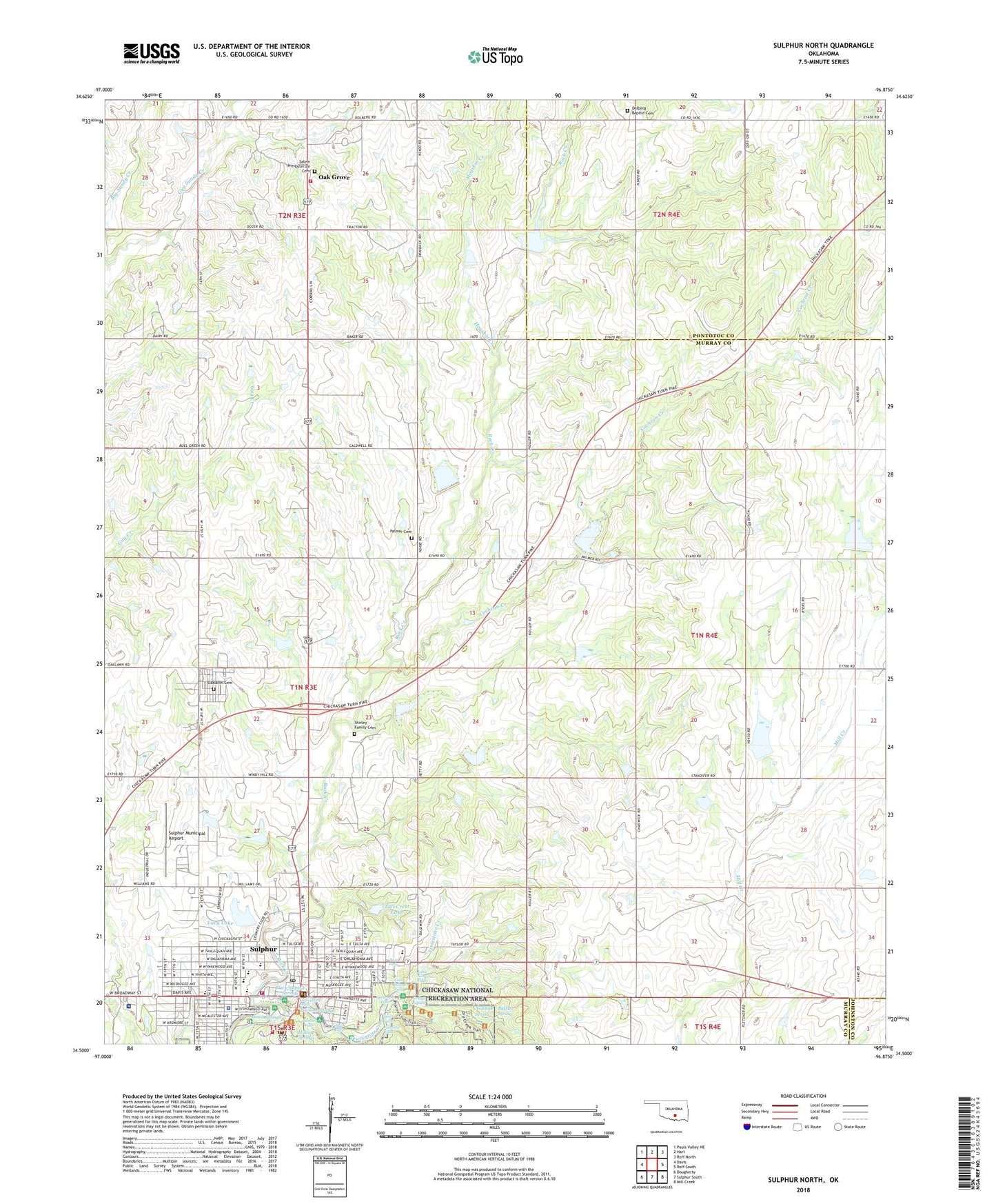
2018 topographic map quadrangle Sulphur North in the state of Oklahoma. Scale: 1:24000. Based on the newly updated USGS 7.5' US Topo map series, this map is in the following counties: Murray, Pontotoc, Johnston. The map contains contour data, water features, and other items you are used to seeing on USGS maps, but also has updated roads and other features. This is the next generation of topographic maps. Printed on high-quality waterproof paper with UV fade-resistant inks.
Quads adjacent to this one:
West: Davis
Northwest: Pauls Valley NE
North: Hart
Northeast: Roff North
East: Roff South
Southeast: Mill Creek
South: Sulphur South
Southwest: Dougherty
Contains the following named places: Antelope Spring, Arbuckle Memorial Hospital, Beach Springs, Bear Falls, Bear Falls Dam, Black Sulphur Springs, Buffalo Spring, Cameron School, Cave Island Falls, Central Campground Dam, Chickasaw National Recreational Area Wild Lands Fire Fighting, Church of Christ, Church of God of Prophesy, Cochran Creek, Cold Springs 1 Dam, Cold Springs 2 Dam, Dolberg Baptist Church, Dolberg Cemetery, Faith Christian School, First Assembly of God, First Baptist Church, First Christian Church, First Freewill Baptist Church, First United Methodist Church, Garfield Falls, Grand Rapids, Hillside Springs, Hogskin Creek, KFNC-FM (Sulphur), Kingdom Hall Jehovahs Witnesses, Lacy Dam, Lacy Lake, Lake Placid, Limestone Creek, Little Niagara Falls, Little Niagra Dam, Lost Falls, Memorial Freewill Baptist Church, Mill Creek Watershed 13 Dam, Mill Creek Watershed 13 Reservoir, Mill Creek Watershed 2 Dam, Mill Creek Watershed 2 Reservoir, Mill Creek Watershed 5 Dam, Mill Creek Watershed 5 Reservoir, Mill Creek Watershed 6 Dam, Mill Creek Watershed 6 Reservoir, Mill Creek Watershed 7 Dam, Mill Creek Watershed 7 Reservoir, Mill Creek Watershed 9 Dam, Mill Creek Watershed 9 Reservoir, Murray County Emergency Medical Services Station 1, Murray County Jail, Murray County Sheriff's Office, Oak Grove, Oak Grove Volunteer Fire Department, Oaklawn Cemetery, Oklahoma School for the Deaf, Palmer Cemetery, Panther Falls, Panther Falls Dam, Pavilion Springs, Pebble Falls, Pentecostal Holiness Church, Rock Creek Site 10 Dam, Rock Creek Site 10 Reservoir, Rock Creek Site 11 Dam, Rock Creek Site 11 Reservoir, Rock Creek Site 12 Dam, Rock Creek Site 12 Reservoir, Rock Creek Site 15 Dam, Rock Creek Site 15 Reservoir, Rock Creek Site 17 Dam, Rock Creek Site 17 Reservoir, Rock Creek Site 9 Dam, Rock Creek Site 9 Reservoir, Saint Francis Xavier Catholic Church, Salem Presbyterian Cemetery, Shirley Family Cemetery, Sulphur, Sulphur Elementary School, Sulphur Fire Department, Sulphur High School, Sulphur Intermediate Elementary School, Sulphur Middle School, Sulphur Municipal Airport, Sulphur Police Department, Sulphur Post Office, Sycamore Falls, Township of Leeper, Travertine Creek, Travertine Falls, Tull Crest Lake, Washington School