MyTopo
Brookings Oregon US Topo Map
Couldn't load pickup availability
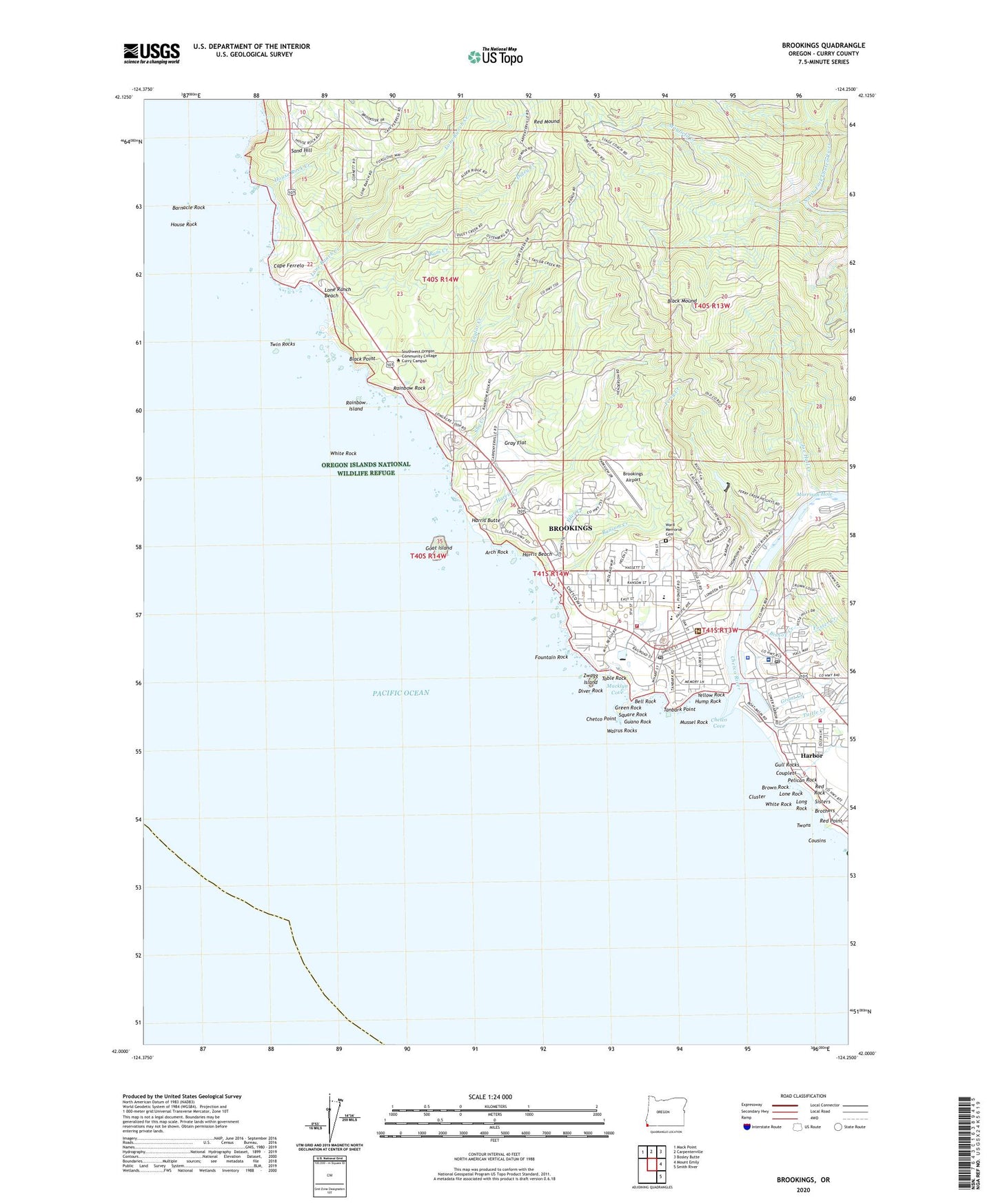
2020 topographic map quadrangle Brookings in the state of Oregon. Scale: 1:24000. Based on the newly updated USGS 7.5' US Topo map series, this map is in the following counties: Curry. The map contains contour data, water features, and other items you are used to seeing on USGS maps, but also has updated roads and other features. This is the next generation of topographic maps. Printed on high-quality waterproof paper with UV fade-resistant inks.
Quads adjacent to this one:
Northwest: Mack Point
North: Carpenterville
Northeast: Bosley Butte
East: Mount Emily
Southeast: Smith River
Contains the following named places: Arch Rock, Azalea City Park, Azalea Middle School, Bankus Fountain, Barnacle Rock, Bell Rock, Bishop Creek, Black Mound, Black Point, Bravo Creek, Brookings, Brookings - Harbor High School, Brookings Airport, Brookings City Hall, Brookings Fire and Rescue, Brookings Harbor Christian School, Brookings Log Pond Dam, Brookings Municipal Court, Brookings Police Department, Brookings Post Office, Brookings Public Works, Brookings Recreation Site, Brookings Wastewater Treatment Plant, Brookings Water Treatment Plant, Brothers, Brown Rock, Bud Cross Park, Cal - Ore Life Flight Ground, Cape Ferrelo, Chetco Community Public Library, Chetco Cove, Chetco Point, Chetco Point Park, Chetco Ranger Station, Chetco River, Church of Jesus Christ of Latter Day Saints, City of Brookings, Cluster, Couplets, Cousins, Curry County Sheriff's Station, Curry Public Transit Dispatch Facility, Department of Motor Vehicles Brookings, Diver Rock, Duley Creek, Easy Manor Park, Eiler Creek, Fern Post Office, Ferry Creek, Ferry Creek Dam, Ferry Post Office, Foster Creek, Fountain Rock, Garvins Airfield, Goat Island, Grant Creek, Gray Flat, Gray Post Office, Green Rock, Guano Rock, Gull Rocks, Harbor, Harbor Census Designated Place, Harbor Post Office, Harbor Rural Fire Protection District, Harris Beach, Harris Beach State Park, Harris Butte, Harris Creek, House Rock, House Rock Creek, Hump Rock, Joe Hall Creek, Kalmiopsis Elementary School, KURY-AM, KURY-FM, Lone Ranch Beach, Lone Ranch Creek, Lone Rock, Long Rock, Macklyn Cove, Macklyn Creek, Mayfield Creek, Morrison Hole, Mussel Rock, Oregon Coast Log Pond, Pelican Bay Lighthouse, Pelican Rock, Performing Arts Center and Community Theatre, Port of Brookings Harbor, Port of Brookings Harbor Boat Ramp, Port of Brookings Harbor Boat Ramp North, Rainbow Island, Rainbow Rock, Rainbow Rock Service Association Sewage Treatment Facility, Ram Creek, Ransom Creek, Red Mound, Red Point, Red Rock, Richards Street Park, Saint Timothys Episcopal Church, Samuel H Boardman State Park, Sand Hill, Shy Creek, Sisters, South Coast Log Pond, Sport Haven Trailer Park Recreation Site, Square Rock, Stack Creek, Stout Park, Table Rock, Tanbark Point, Taylor Creek, Tuttle Creek, Twin Rocks, Twons, United States Coast Guard Motor Lilfeboat Station Chetco River, United States Coast Guard Station Chetco River, Walrus Rocks, Ward Memorial Cemetery, White Rock, Yellow Rock, Zwagg Island