MyTopo
Coos Bay Oregon US Topo Map
Couldn't load pickup availability
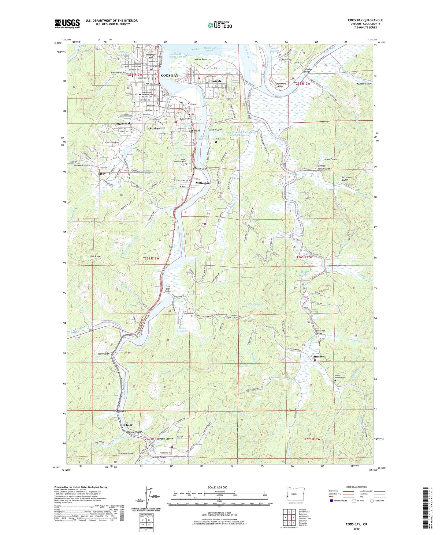
2020 topographic map quadrangle Coos Bay in the state of Oregon. Scale: 1:24000. Based on the newly updated USGS 7.5' US Topo map series, this map is in the following counties: Coos. The map contains contour data, water features, and other items you are used to seeing on USGS maps, but also has updated roads and other features. This is the next generation of topographic maps. Printed on high-quality waterproof paper with UV fade-resistant inks.
Quads adjacent to this one:
West: Charleston
Northwest: Empire
North: North Bend
Northeast: Allegany
East: Daniels Creek
Southeast: McKinley
South: Coquille
Southwest: Riverton
Contains the following named places: 10th Street Park, 97420, Alder Spring, Archer Cemetery, Archie Gulch, Bay Park, Belfast Mine, Blake Gulch, Blossom Gulch, Blossom Gulch Elementary School, Boardwalk Park, Boatman Gulch, Boone Creek, Bowron Gulch, Brainard Creek, Brodie Gulch, Bunker Hill, Bunker Hill Census Designated Place, Bunker Hill Elementary School, Bunker Hill Mine, Bunker Hill Post Office, C A Smith Dam, C A Smith L and M Company Storage Reservoir, Cardwell Creek, Catching Creek, Catching Slough, Chandler Bridge, Chezik Spring, Cleo, Coalbank Creek, Coalbank Slough, Colliver Springs, Coos Art Museum, Coos Bay, Coos Bay City Dock North, Coos Bay City Dock South, Coos Bay City Docks, Coos Bay City Hall, Coos Bay Fire Department Central Station 1, Coos Bay Fire Department Eastside Station, Coos Bay Foursquare Church, Coos Bay Municipal Court, Coos Bay Police Department, Coos Bay Post Office, Coos Bay Public Library, Coos Bay Public Works, Coos Bay Speedway, Coos City, Coos City Bridge, Coos City Post Office, Coos County Area Transit Dispatch Facility, Coos Forest Protective Association, Coos Golf Club, Coos River, Davis Creek, Davis Slough, Delmar, Delmar Creek, Delmar Post Office, Department of Motor Vehicles Coos Bay, Eastside, Eastside Boat Ramp, Eastside Elementary School, Eastside Park, Eastside Post Office, Echo Valley, Egyptian Theatre, Englewood, Englewood Mine, Englewood School, Ferry Creek, Goat Creek, Graveyard Point, Green Acres, Green Acres School, Greenacres Rural Fire Protection District, Greyhound Station, Hayden, Haydon, Haynes Cemetery, Henryville Post Office, Independent Order of Odd Fellows Cemetery, Inlet, Isthmus Slough, KHSN-AM, Kings Landing, Kruse Ponds, KYNG - AM, KYNG-FM, Lake Merritt, Laxstrom Gulch, Libby, Libby Mine, Libby Post Office, Lillian Creek, Lone Tree Bridge, Lyons Reservoir, Manning Gulch, Marshfield Channel, Marshfield Range Channel, Marshfield Senior High School, Marshfield Sun Printing Museum, Masters Landing, Matson Creek, Maxwell, Maxwell Post Office, McCormac, Mill Spur, Miller Reservoir, Millicoma Intermediate School, Millington, Millington Rural Fire Protection District 5 Station 1, Millington Rural Fire Protection District 5 Station 2, Mingus Park, Mingus Park Creek, Mingus Park Lake, Monkey Ranch Gulch, Noble Creek, Oregon Coast Historical Railways, Panther Creek, Pogue Gulch, Port Barnum, Resource Link Charter School, Ross Slough, Saint Monicas Catholic Church, Section Base Post Office, Seelander Creek, Shinglehouse Slough, Sigsby Spring, Smith Reservoir, Smith-Powers Mine, Snedden Creek, South Harbor, Southport, Southport Creek, Southport Mine, Stock Slough, Sumner, Sumner Grange, Sumner Pioneer Cemetery, Sumner Post Office, Sumner Rural Fire Protection District Station 1, Sunset, Sunset Memorial Park, Sunset Post Office, Telegraph Hill, The Buttes, Thirty Six Mine, Utter City Post Office, Vogel Creek, Wall Gulch, Wallace Gulch, Watsonville, Westlog Airstrip, White Point, Wilson Creek, Windy Hill Park