MyTopo
North Bend Oregon US Topo Map
Couldn't load pickup availability
Also explore the North Bend Forest Service Topo of this same quad for updated USFS data
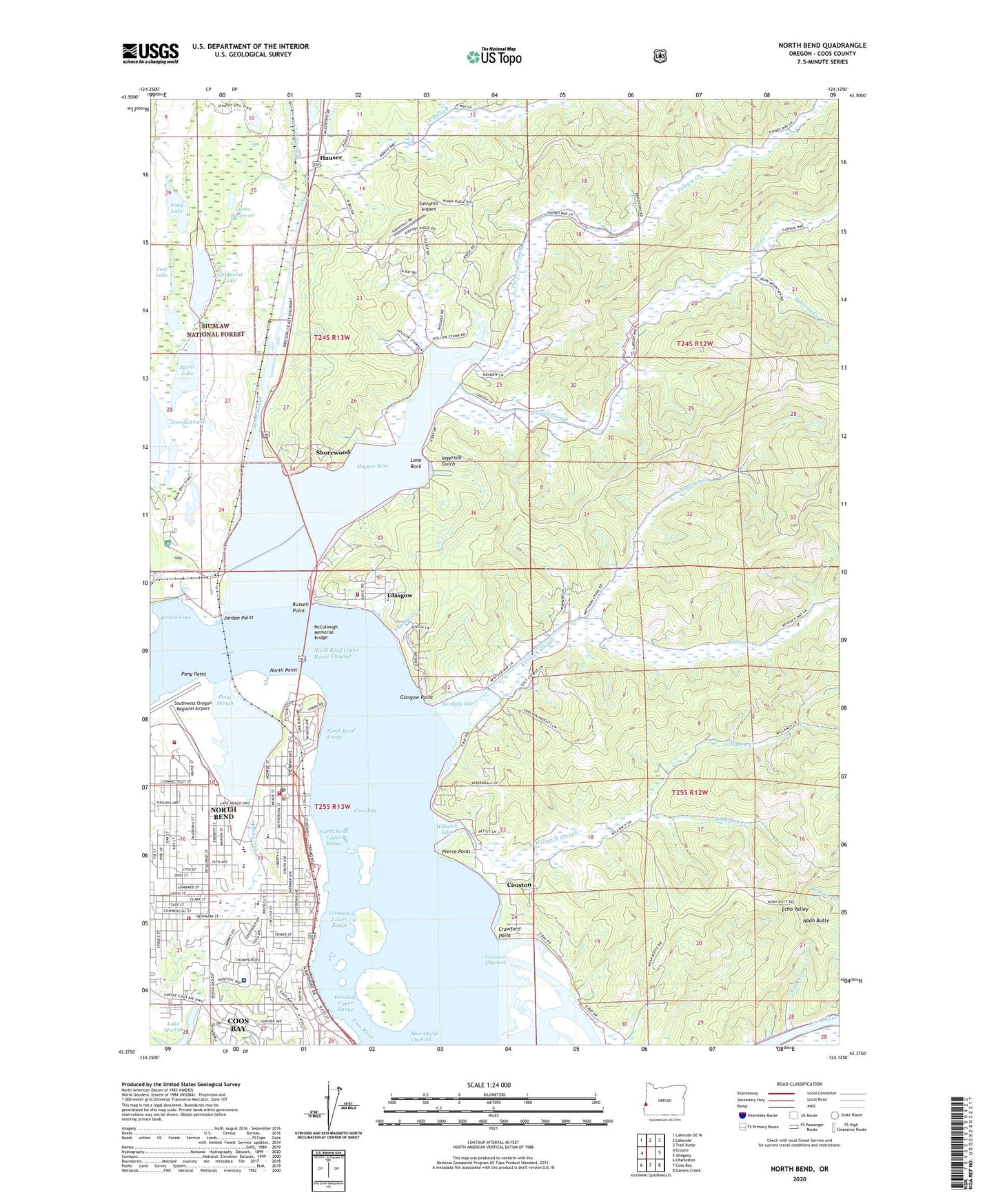
2024 topographic map quadrangle North Bend in the state of Oregon. Scale: 1:24000. Based on the newly updated USGS 7.5' US Topo map series, this map is in the following counties: Coos. The map contains contour data, water features, and other items you are used to seeing on USGS maps, but also has updated roads and other features. This is the next generation of topographic maps. Printed on high-quality waterproof paper with UV fade-resistant inks.
Quads adjacent to this one:
West: Empire
Northwest: Lakeside OE W
North: Lakeside
Northeast: Trail Butte
East: Allegany
Southeast: Daniels Creek
South: Coos Bay
Southwest: Charleston
This map covers the same area as the classic USGS quad with code o43124d2.
Contains the following named places: Bangor Elementary School, Bangor Post Office, Bay Area Church of the Nazarene, Bay Area Hospital, Bay Area Hospital Heliport, Boynton Park, California Boat Ramp, Christ Lutheran School, Church of God of North Bend Oregon, City of Coos Bay, City of North Bend, College Park, Conde B McCullough State Park Boat Ramp, Conde B McCullough State Recreation Site, Coos Bay - North Bend Water Board Shorewood Water Treatment Plant, Coos Bay Wastewater Treatment Plant, Coos County Public Health Department, Coos Historical and Maritime Museum, Coos School, Cooston, Cooston Channel, Cooston Post Office, Cordes, Crawford Point, Ferndale Lower Range, Ferndale Upper Range, Ferry Road Park, Glasgow, Glasgow Census Designated Place, Glasgow Point, Gold Coast Seventh - Day Adventist Christian School, Grange Creek, Hauser, Hauser Post Office, Haynes Inlet, Hillcrest Elementary School, Horsfall Recreation Site, Ingersoll Gulch, Johnston Creek, Jordan Cove, Jordan Point, KBBR-AM, KCBY-TV, Keizer Memorial Hospital, Kentuck Country Club, Kentuck Creek, Kentuck Inlet, Kentuck Slough, Kentuck Slough Post Office, KICR-FM, Kingsview Christian School, KOOS-FM, Larson Creek, Larson Slough, Little Theatre on the Bay, Lone Rock, Lower Pony Creek Dam, Lyons Reservoir, May Post Office, McCullough Memorial Bridge, Menasha Pad, Mettman Creek, Milner Crest Elementary School, Navy 10146 Post Office, Noah Butte, Noah Creek, North Bay Rural Fire Protection District, North Bend, North Bend Annex of the Coos County Courthouse, North Bend City Hall, North Bend Fire Department Station 2, North Bend Fire Station 1, North Bend Fire Station 3, North Bend Library, North Bend Lower Range Channel, North Bend Middle School, North Bend Police Department, North Bend Post Office, North Bend Public Works, North Bend Range, North Bend Senior High School, North Bend Upper Range, North Point, North Slough, Oak Street Park, Oregon Coast Technology School, Palouse Creek, Palouse Slough, Pierce Point, Pony Creek, Pony Point, Pony Slough, Pony Village Mall Children's Theatre, Pony Village Post Office, Red Cross Blood Services Bay Area Hospital, Reedsport Water Treatment Plant, Rogers, Roosevelt Elementary School, Russell Point, Sandpoint Lake, Sandtrack Recreation Site, Shorewood, Simpson Park, Snag Lake, Southwest Oregon Regional Airport, Spirit Lake, State Street Park, Stave Mill, Sullivan Creek, Sunny Hill Elementary School, Sunnyhill Airport, Teal Lake, United States Coast Guard Cutter Orcas Station, United States Coast Guard Group Air Station North Bend, United States Customs and Border Protection Port of Entry Coos Bay, Willanch Creek, Willanch Inlet, Willanch Slough, Winsor Park, ZIP Code: 97459