MyTopo
Estacada Oregon US Topo Map
Couldn't load pickup availability
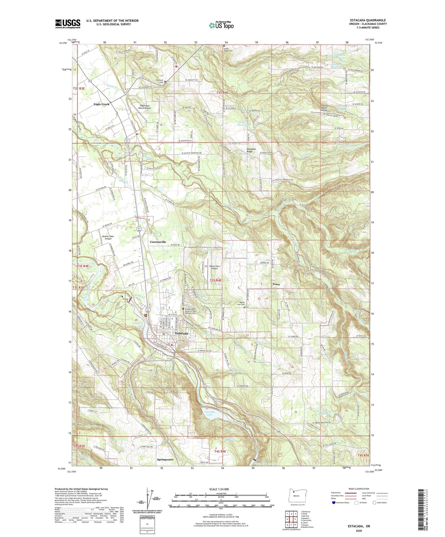
2020 topographic map quadrangle Estacada in the state of Oregon. Scale: 1:24000. Based on the newly updated USGS 7.5' US Topo map series, this map is in the following counties: Clackamas. The map contains contour data, water features, and other items you are used to seeing on USGS maps, but also has updated roads and other features. This is the next generation of topographic maps. Printed on high-quality waterproof paper with UV fade-resistant inks.
Quads adjacent to this one:
West: Redland
Northwest: Damascus
North: Sandy
Northeast: Bull Run
East: Cherryville
Southeast: Bedford Point
South: Elwood
Southwest: Colton
Contains the following named places: Alspaugh, Bear Creek, Beaver Oaks Airport, Burglund Pond, Camp Millard, Cazadero, Cazadero Dam, Cazadero Post Office, Cazadero Powerhouse, Church of Jesus Christ of Latter Day Saints, City of Estacada, Clackamas Fire District Number 1 Eagle Creek Community Fire Station Number 18, Clackamas River Elementary School, Clackamas Valley Baptist Church, Country Squire Airpark, Currin Cemetery, Currin Creek, Currinsville, Currinsville Post Office, Deep Creek Reservoir, Delph Creek, Delshazer Spring, Douglass Ridge, Dubois Creek, Eagle Creek, Eagle Creek Elementary School, Eagle Creek Foursquare Church, Eagle Creek Post Office, Eagle Creek Presbyterian Church, Eagle Fern Park, Eagle Fern Youth Camp, Eagle Nest Ranch Airport, Estacada, Estacada Assembly of God Church, Estacada Auditorium, Estacada Christian Church, Estacada City Hall, Estacada Fire District Main Station, Estacada First Baptist Church, Estacada High School, Estacada Junior High School, Estacada Lake, Estacada Municipal Court, Estacada Park and Ride, Estacada Post Office, Estacada Public Library, Estacada Public Works, Estacada Ranger Station, Estacada Seventh - day Adventist Church, Estacada United Methodist Church, Estacada Wastewater Treatment Facility, Faraday, Faraday Lake, Faraday Lake Dam, Forrester Cemetery, Garfield, Garfield Community Church, Garfield Post Office, Hidden Valley, Independent Order of Odd Fellows Cemetery, Isaackson Reservoir, Kromer Reservoir, Leewood Camp, Linglebeck Creek, Middle Falls, Mill River Park, Milo McIver State Park, Milo McIver State Park Southern Boat Ramp, Milwaukie Plywoood Corporation Dam, Milwaulie Plywood Corporation Log Pond, Mount Zion Cemetery, North Fork Eagle Creek, North Fork Wade Creek, Philip Foster Cemetery, Phillip Foster Farm, River Mill, River Mill Dam, River Mill Elementary School, River Mill Powerhouse, River Mill Reservoir, Saint Aloysius Catholic Church, Saling Creek, Sandy Ridge Cemetery, Shockley Reservoir, Slow Springs Reservoir, South Fork Wade Creek, Spring Creek, Springwater, Springwater Post Office, The Falls, Timber Park Boat Launch, Tracy, Valley View Airport, Wade Creek, ZIP Codes: 97022, 97023