MyTopo
Klamath Falls Oregon US Topo Map
Couldn't load pickup availability
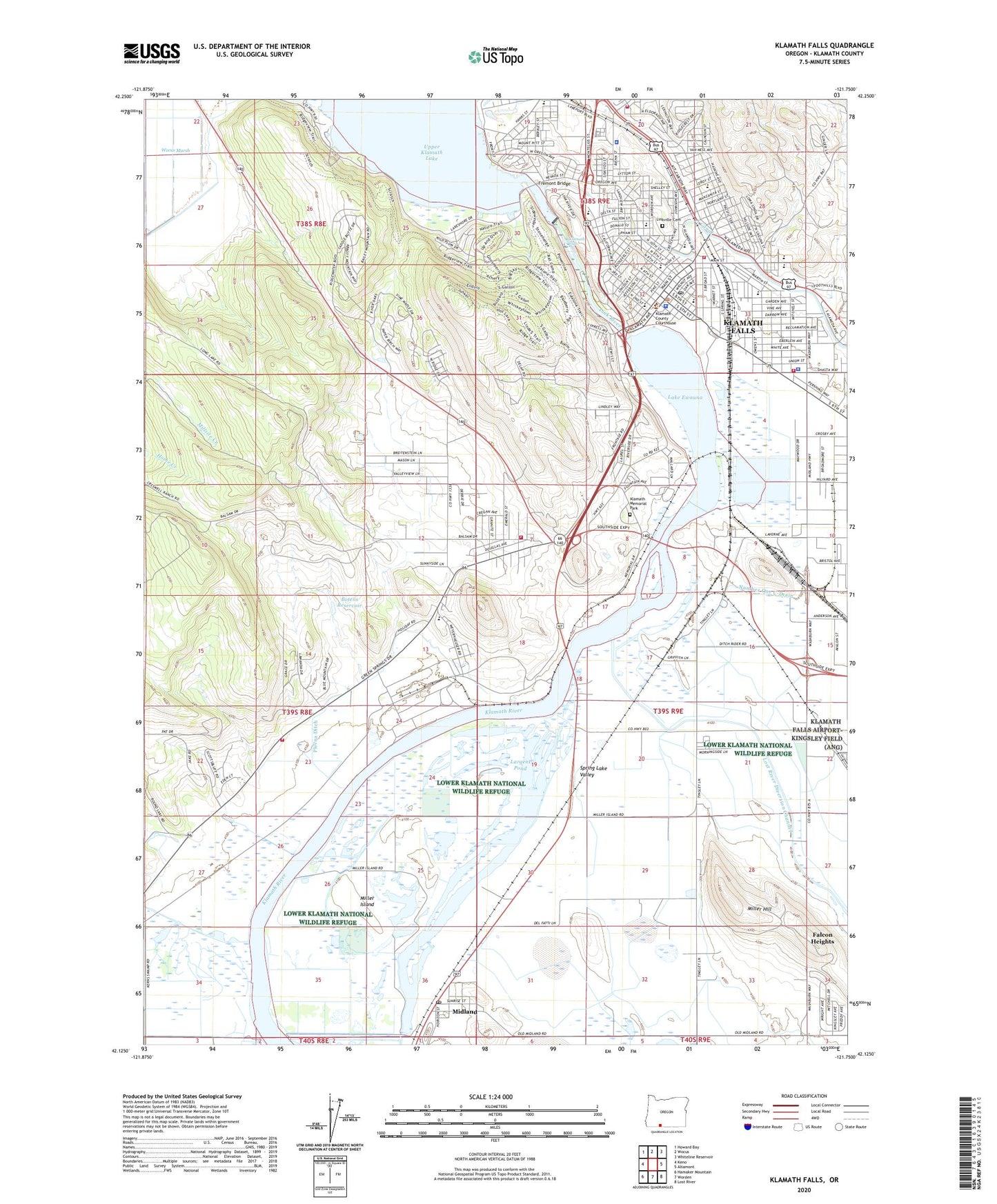
2024 topographic map quadrangle Klamath Falls in the state of Oregon. Scale: 1:24000. Based on the newly updated USGS 7.5' US Topo map series, this map is in the following counties: Klamath. The map contains contour data, water features, and other items you are used to seeing on USGS maps, but also has updated roads and other features. This is the next generation of topographic maps. Printed on high-quality waterproof paper with UV fade-resistant inks.
Quads adjacent to this one:
West: Keno
Northwest: Howard Bay
North: Wocus
Northeast: Whiteline Reservoir
East: Altamont
Southeast: Lost River
South: Worden
Southwest: Hamaker Mountain
This map covers the same area as the classic USGS quad with code o42121b7.
Contains the following named places: American Red Cross Klamath Falls Donor Center, American Red Cross Klamath Lake District Office, Balsam Road Quarry, Basin Transit Service Downtown Transit Center, Bieber Line Junction, Botens Reservoir, Bureau of Land Management Klamath Falls Resource Area Field Office, Bureau of Reclamation Klamath Basin Area Office, Chelsea, Children's Museum of Klamath Falls, City of Klamath Falls, Conger Heights Park, Conger School Park, Department of Motor Vehicles Klamath Falls, Dillon Field, Eagleridge High School, Eldorado Park, Ella Redkey Municipal Pool, Fairhaven, Fairhaven Elementary School, Fairview Elementary School, Fairview Park, Falcon Heights, Falcon Heights Census Designated Place, Falcon Heights School, Favell Museum, Fremont Bridge, Green Springs Junction, Henderson Park, Hilltop Christian Academy, Joseph Conger Elementary School, KAGO - AM, KAGO - FM, Keno Canal, Keno Rural Fire Protection District Station 3, KFLS - AM, Kit Carson Park, KLAD - AM, KLAD - FM, Klamath County Circuit Courthouse, Klamath County Department of Public Health, Klamath County Fire District 1 Station 3, Klamath County Fire District 1 Station 4, Klamath County Fire District 1 Station 6 Headquarters, Klamath County Fire District 4, Klamath County Library, Klamath County Loyd de Lap Law Library, Klamath County Museum, Klamath County Museums Baldwin Hotel Museum, Klamath County Public Works Department Office, Klamath Falls, Klamath Falls City Hall, Klamath Falls Division, Klamath Falls Greyhound Station, Klamath Falls Municipal Court, Klamath Falls Police Department, Klamath Falls Police Substation, Klamath Falls Post Office, Klamath Falls Public Works Department Office, Klamath Falls Wastewater Treatment and Reclamation Facility, Klamath Falls Yard, Klamath Generation Project, Klamath Memorial Park, Klamath Union High School, Klamath Wildlife Area, Klamath Youth Development Center, Klein Park, Krause Park, KTEC - FM, Lake Ewauna, Largent Pond, Link River, Link River Dam, Linkville Cemetery, Linkville Playhouse, Merganser, Merganser Post Office, Midland, Midland Grange, Midland Post Office, Midland Safety Rest Area, Miller Hill, Miller Island, Miller Island Boat Ramp, Mills Elementary School, Mills Little League Park, Mills-Kiwanis Park, Monroe Park Marina Boat Ramp 1, Monroe Park Marina Boat Ramp 2, Moore Park, Moore Park Marina 1, OC&E Woods Line State Trail, O'Neill School, Oregon State Police Department Klamath Falls, Pacific Power & Light Substation, Pacific Terrace Park, Pelican Elementary School, Pelican Marina, Plevna Ditch, Ponderosa Junior High School, Putnams Point, Reames Country Club, Richmond Park, Riverside Elementary School, Roosevelt Elementary School, Ross Ragland Theater, Sacred Heart Academy, South Klamath, South Suburban Sanitary District Sewage Treatment, Spring Lake Valley, Stewart Lenox, Stukel Park, Texum, United States Fish and Wildlife, Veterans Memorial Park, Veterans Memorial Park Boat Ramp, Veterans Memorial Park Marina, Veterans Memorial Park Outdoor Stage, Warford Park, West Klamath, Wocus Bay Boat Launch, ZIP Code: 97634