MyTopo
Newport North Oregon US Topo Map
Couldn't load pickup availability
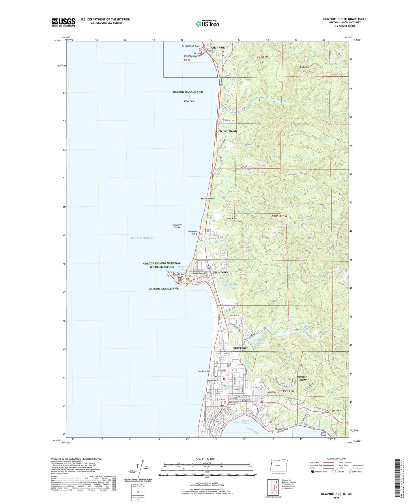
2024 topographic map quadrangle Newport North in the state of Oregon. Scale: 1:24000. Based on the newly updated USGS 7.5' US Topo map series, this map is in the following counties: Lincoln. The map contains contour data, water features, and other items you are used to seeing on USGS maps, but also has updated roads and other features. This is the next generation of topographic maps. Printed on high-quality waterproof paper with UV fade-resistant inks.
Quads adjacent to this one:
North: Depoe Bay
Northeast: Mowrey Landing
East: Toledo North
Southeast: Toledo South
South: Newport South
This map covers the same area as the classic USGS quad with code o44124f1.
Contains the following named places: Agate Beach, Agate Beach Cemetery, Agate Beach Golf Course, Agate Beach Post Office, Agate Beach State Park, Anderson Creek, Bains Creek, Batemans Chelan Abbey Mausoleum, Bay Post Office, Bay Street Tie Up Boat Dock, Beverly Beach, Beverly Beach State Park, Big Creek, Big Creek Dam Number 1, Big Creek Dam Number 2, Big Creek Reservoir Number One, Blattner Creek, Buford Hill, Carolyn Brown School, Coal Creek, Cold Springs Reservoir, Department of Motor Vehicles Newport, Depoe Bay Rural Fire Protection District Station 2400 - Otter Rock, Devils Punch Bowl, Devils Punchbowl Arch, Devils Punchbowl State Park, Embarcadero Marina Resort, Embarcadero Marina Resort Docks, Eureka Cemetery, Frank Wade Park, Greyhound and Valley Retriever Bus Depot, Hurbert Creek, Iron Mountain, Isaac Newton Magnet School, Jeffries Creek, Johnson Creek, Jumpoff Joe, KCEL-FM, Kistler Spring, KNPT-AM, Lighthouse Vineyard Christian Fellowship, Lincoln County Courthouse, Lincoln County Jail, Lincoln County Public Health Department, Lincoln County Public Works, Lincoln County Rodeo and Fairgrounds, Lincoln County Sheriff's Office, Lincoln County Transit, Little Creek, Little Schooner Creek, Lucky Gap Creek, Martin Falls, McLean Point, Miner Creek, Moolack Beach, Moolack Creek, Moores Spring, Newport, Newport City Hall, Newport Division, Newport Fire Department Station 1, Newport Foursquare Church, Newport Heights, Newport High School, Newport Municipal Court, Newport Performing Arts Center Alice Silverman Theatre, Newport Police Department, Newport Post Office, Newport Public Library, Newport Public Works, Newport Reservoir, Newport Water Treatment Plant, North Fork Spencer Creek, Nye Beach, Nye Beach Post Office, Nye Creek, Ocean Park, Olson Creek, Oregon Coast History Center, Oregon State Police Department Newport, Otter Rock, Otter Rock Post Office, Pacific Communities Hospital Heliport, Pacific West Ambulance, Port Docks Bay Front, Red Cross Blood Services, Red Cross Lincoln District, Rocky Top, Sam Case Elementary School, Samaritan Pacific Communities Hospital, Schooner Creek, Schooner Point, Schooner Rocks, South Fork Spencer Creek, Spencer Creek, Starfish Cove, United States Customs and Border Protection Port of Entry Newport, Wade Creek, Yaquina Bay Lighthouse Interpretive Center, Yaquina Head, Yaquina Head Lighthouse, Yaquina View Elementary School, ZIP Code: 97365