MyTopo
Scholls Oregon US Topo Map
Couldn't load pickup availability
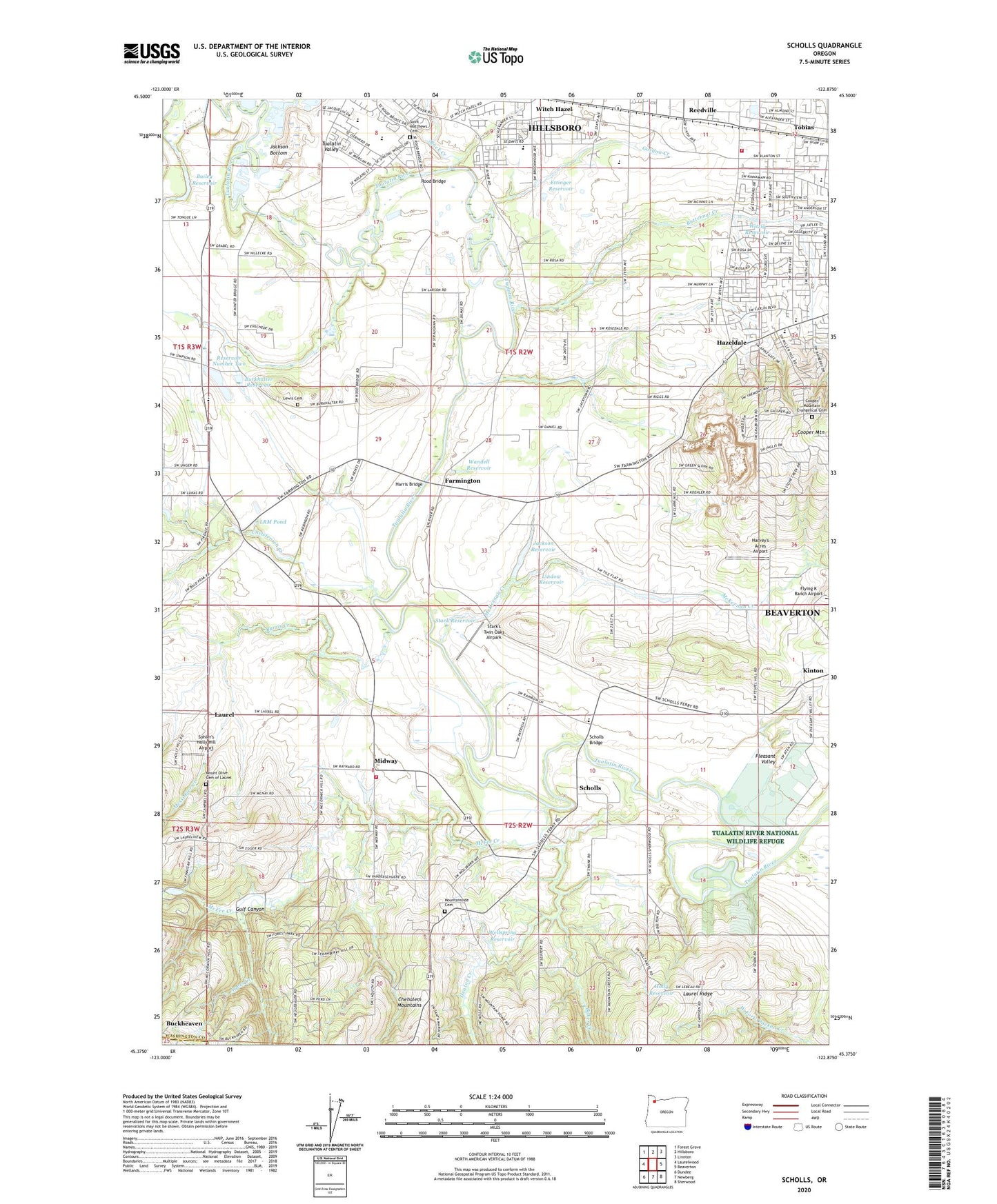
2024 topographic map quadrangle Scholls in the state of Oregon. Scale: 1:24000. Based on the newly updated USGS 7.5' US Topo map series, this map is in the following counties: Washington, Yamhill. The map contains contour data, water features, and other items you are used to seeing on USGS maps, but also has updated roads and other features. This is the next generation of topographic maps. Printed on high-quality waterproof paper with UV fade-resistant inks.
Quads adjacent to this one:
West: Laurelwood
Northwest: Forest Grove
North: Hillsboro
Northeast: Linnton
East: Beaverton
Southeast: Sherwood
South: Newberg
Southwest: Dundee
This map covers the same area as the classic USGS quad with code o45122d8.
Contains the following named places: Aloha Bible Church, Ayers Creek, Bailey Dam, Bailey Reservoir, Baker Creek, Beaverton Quarry, Buckheaven, Burkhalter Reservoir, Burris Creek, Butternut Creek, Butternut Creek Elementary School, Butternut Park, Calvary Chapel Worship Center, Camp Rivendale, Campbell Road Nursery, Chehalem Mountain Nursery, Christensen Creek, Church of Jesus Christ of Latter Day Saints, Columbia Empire Farms, Cooper Mountain Evangelical Cemetery, Cooper Mountain Presbyterian Church, Dam Number 2, Davis Creek, Decker Farms, Elizabeth Meadows Park, Eshraghi Nursery, Ettinger Dam, Ettinger Reservoir, Extra Perennial Nursery, Farmington, Farmington Post Office, Farmington View Elementary School, Friendship Christian Fellowship Church, Gold Hill Nursery, Gordon Creek, Groner Elementary School, Gulf Canyon, Harris Bridge, Harris Ferry Post Office, Harvey's Acres Airport, Hazeldale, Hazeldale Elementary School, Hazeldale Park, Heaton Creek, Hillsboro High School, Holly Reservoir, Immanuel Community Church, India Full Gospel Church, Intel Aloha Wetlands Park, Jackson Reservoir, Jackson Slough, Jacktown, Jenkins Estate, Kinnaman Elementary School, Kinton, Kinton Post Office, KUIK-AM, Laurel, Laurel Post Office, Lewis Cemetery, Life Christian School, Life Church, Light of Life Lutheran Church, Lindow Reservoir, LRM Pond, McFee Creek, McKernan Creek, Meadowbrook Park, Meriwether Golf Course, Messinger Creek, Midway, Minter Bridge Elementary School, Mount Olive Cemetery of Laurel, Mountainside Cemetery, New Hope Missionary Baptist Church, Oak Knoll Winery, Oregon Heritage Farms, Palace of Praise United Pentecostal Church, Pfister Farms, Pleasant Valley, Popp Reservoir, Portland Onnuri Church, Prestige Farms, Rainyway Farms, Reedville, Reedville Post Office, Reservoir Number Two, Rock Creek, Rock Creek Advanced Wastewater Treatment Facility, Rood Bridge, Rood Bridge Park, Rosa Park, Russell Middle School, Saint Elizabeth Ann Seton Catholic Church, Saint Matthews Cemetery, Scholls, Scholls Bridge, Scholls Community Church, Scholls Grange Hall, Scholls Post Office, Seven Springs Ranch, Shenandoah Valley Ranch, Sohler's Holly Hill Airport, South Meadows Middle School, Stark Reservoir, Stark's Twin Oaks Airpark, The Reserve Vineyards and Golf Club, Tobias, Trepha M. Baron Pavilion, Tualatin Valley, Tualatin Valley Fire and Rescue Station 19, Tualatin Valley Fire and Rescue Station 62 Aloha, Wandell Reservoir, Ware, Wellspring Reservoir, Witch Hazel Elementary School, Witzig Reservoir, World Heart Ministry, ZIP Codes: 97007, 97123