MyTopo
Sherwood Oregon US Topo Map
Couldn't load pickup availability
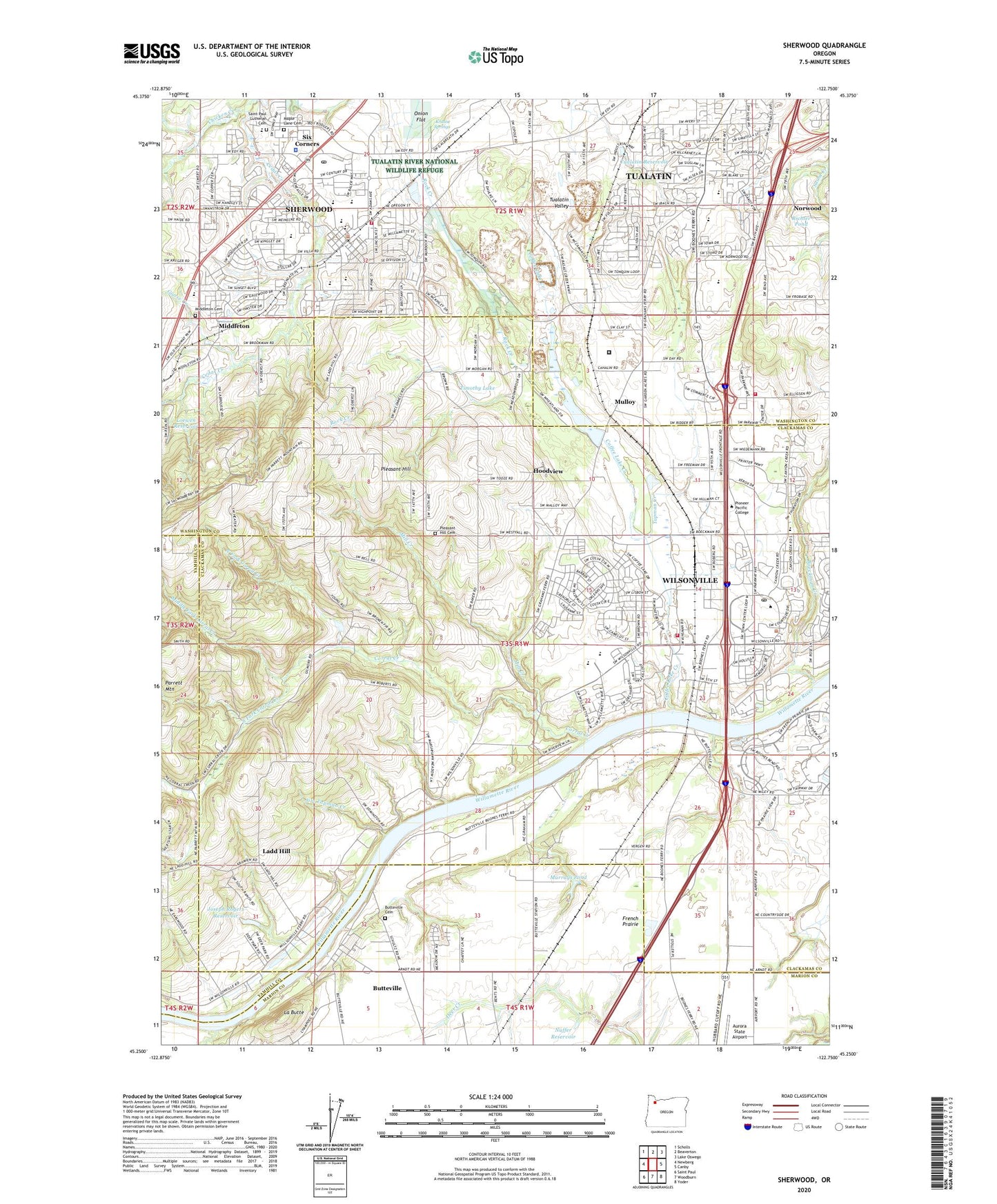
2024 topographic map quadrangle Sherwood in the state of Oregon. Scale: 1:24000. Based on the newly updated USGS 7.5' US Topo map series, this map is in the following counties: Clackamas, Washington, Marion, Yamhill. The map contains contour data, water features, and other items you are used to seeing on USGS maps, but also has updated roads and other features. This is the next generation of topographic maps. Printed on high-quality waterproof paper with UV fade-resistant inks.
Quads adjacent to this one:
West: Newberg
Northwest: Scholls
North: Beaverton
Northeast: Lake Oswego
East: Canby
Southeast: Yoder
South: Woodburn
Southwest: Saint Paul
This map covers the same area as the classic USGS quad with code o45122c7.
Contains the following named places: Archer Glen Elementary School, Arts and Technology Charter High School, Baldock Safety Rest Area, Boeckman Creek, Boon Post Office, Boones Ferry, Boones Ferry City Park, Boones Ferry Community Church, Boones Ferry Community Church Park and Ride, Boones Ferry County Boat Launch, Boones Ferry Landing Boat Ramp, Boones Ferry Marina, Boones Ferry Primary School, Brookforest Pond, Buena Vista, Butteville, Butteville Cemetery, Butteville Census Designated Place, Butteville Community Church, Butteville Post Office, Butteville Station, Cahalin, Callahan Rehabilitation Center, Canyon Creek Church, Cedar Creek, Celebration Church, Century Meadows Sanitary Systems Sewage Treatment Plant, Charbonneau, Cherriots Transit Wilsonville Park and Ride, Cherriots Wilsonville Station, Christ Community Church, Christian Missionary Alliance, Church of Jesus Christ of Latter Day Saints, Cinnamon Hills City Park, Cipole, City of Sherwood, City of Wilsonville, Clutters, Coffee Creek Correctional Facility, Coffee Lake Creek, Coffee Lake Park, Columbia Aviation Heliport, Columbia Helicopters Heliport, Community Campus Park, Corral Creek, Countryside Community Church, Courtside City Park, Creekside Bible Church, Curtis, Dammasch State Hospital, Department of Motor Vehicles Sherwood, Downing, Edward Byron Elementary School, Edy Ridge Elementary School, Ford, Geer Pioneer Cemetery, Glad, Gooding Orchards, Goose Creek, Grace Chapel, Graeme Post Office, Hathaway City Park, Hoodview, Hope Fellowship Church, Horizon Christian Elementary School, Ibach City Park, Inza R Wood Middle School, J Clyde Hopkins Elementary School, Jim Tapman Creek, Joseph Rogers Dam, Joseph Rogers Reservoir, Krause Springs, La Butte, Ladd Hill, Lady Fern City Park, Lafky City Park, Langer City Park, Little Woodrose Natural Area, Living Enrichment Center, Loewen Creek, Loewen Reservoir, Lone Star Ranch, Maine, Maple Lane Cemetery, Memorial City Park, Middle Fork Corral Creek, Middleton, Middleton Cemetery, Middleton Elementary School, Middleton Post Office, Mill Creek, Monte Bella Ranch, Montebello City Park, Mulloy, Murdock City Park, Murrays Pond, Nasoma, North Fork Corral Creek, Norwood, Norwood Bible Church, Nuffer Reservoir, Oregon Trail City Park, Pacific Northwest Academy, Park at Merryfield, Parrett Mountain Farm, Pioneer City Park, Pleasant Hill, Pleasant Hill Cemetery, Prahl, Richter Pond, River Fox City Park, Rock Creek, Ryan Creek, Saarinen Wayside Park, Saint Cyril Catholic Church, Saint Francis Catholic Church, Saint Francis Episcopal Church, Saint Francis School, Saint Paul Lutheran Cemetery, Saint Paul Lutheran Church, Saint Paul Lutheran School, Seely Ditch, Seventh Day Adventist Church, Sherwood, Sherwood City Hall, Sherwood Heritage Center, Sherwood High School, Sherwood Ice Arena, Sherwood Market Center Shopping Center, Sherwood Middle School, Sherwood Municipal Court, Sherwood Park and Ride, Sherwood Plaza Shopping Center, Sherwood Police Department, Sherwood Post Office, Sherwood Public Library, Sherwood Public Works Department, Sherwood Regal Cinemas Park and Ride, Sherwood United Methodist Church, Six Corners, South Fork Corral Creek, Stella Olsen City Park, Stewart, Storwest, Sunset City Park, Tapman Creek, Timothy Lake, Tonquin, Tonquin Post Office, Tonquin Scablands, Town Center City Park, Tranquil City Park, Tri-County Industrial, Tualatin Elementary School, Tualatin High School, Tualatin Hills Christian Church, Tualatin Presbyterian Church, Tualatin Reservoir, Tualatin United Methodist Church, Tualatin Valley Fire and Rescue Station 33 Sherwood, Tualatin Valley Fire and Rescue Station 52 Wilsonville, Tualatin Valley Fire and Rescue Station 56 Elligsen Road, Tualatin Valley Fire and Rescue Training Center, Union High School, United States Fish and Wildlife Service Office of Law Enforcement, Valley Christian Church, Veterans Memorial City Park, Victoria Woods Natural Area, Wallace, Wallamette Post Office, West Fork Chicken Creek, Wiedeman City Park, Wilsonville, Wilsonville City Hall, Wilsonville Division, Wilsonville Memorial Park Boat Dock, Wilsonville Municipal Court, Wilsonville Post Office, Wilsonville Public Library, Wilsonville Public Works, Wilsonville School, Wilsonville United Methodist Church, Wilsonville Wastewater Treatment Plant, Woodhaven City Park, Woodhaven Community Church, Yam Hill Post Office, ZIP Codes: 97062, 97070, 97140