MyTopo
Woodburn Oregon US Topo Map
Couldn't load pickup availability
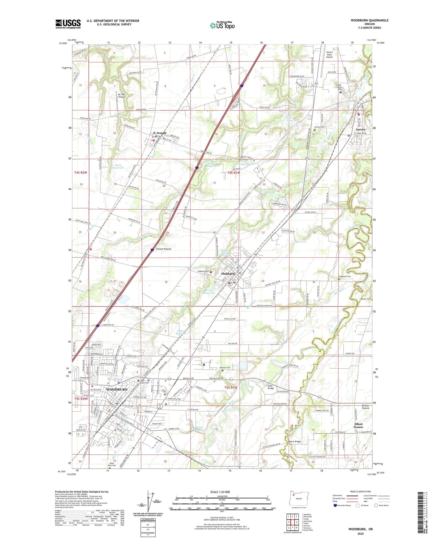
2023 topographic map quadrangle Woodburn in the state of Oregon. Scale: 1:24000. Based on the newly updated USGS 7.5' US Topo map series, this map is in the following counties: Marion, Clackamas. The map contains contour data, water features, and other items you are used to seeing on USGS maps, but also has updated roads and other features. This is the next generation of topographic maps. Printed on high-quality waterproof paper with UV fade-resistant inks.
Quads adjacent to this one:
West: Saint Paul
Northwest: Newberg
North: Sherwood
Northeast: Canby
East: Yoder
Southeast: Scotts Mills
South: Silverton
Southwest: Gervais
This map covers the same area as the classic USGS quad with code o45122b7.
Contains the following named places: Academy of International Studies at Woodburn, Aurora, Aurora Cemetery, Aurora City Hall, Aurora Municipal Court, Aurora Police Department, Aurora Post Office, Aurora Public Works, Aurora Rural Fire Protection District Donald, Aurora Rural Fire Protection District Headquarters, Aurora Sewage Treatment Plant, Aurora State Airport, Belle Passi Cemetery, Blosser Cemetery, Brandy Creek, Broadacres, Broadacres Post Office, Bronec Reservoir, Butte Creek, Centennial Park, Church of Jesus Christ of Latter Day Saints, City of Aurora, City of Donald, City of Hubbard, City of Woodburn, Cowan Park, Deer Creek, Department of Motor Vehicles Woodburn, Donald, Donald City Hall, Donald Post Office, Donald Public Works Department Office, Donald Sewage Treatment Plant, Elliott Prairie, Elliott Prairie Christian School, Fargo, Fellers, Fowler Reservoir, Fredericks Dam, Fredericks Reservoir, French Prairie Middle School, Fry Creek, Fry Reservoir, Giesy Mineral Spring, Greyhound Station Woodburn La Caseta D Woodburn, Handy, Handy Post Office, Heritage Elementary School, Heritage Park, Hermanson Park I, Hermanson Park II, Hermanson Park III, Highway Post Office, Hito, Hoch Reservoir, Hofer, Hopewell Cemetery, Hubbard, Hubbard Cemetery, Hubbard City Hall, Hubbard Division, Hubbard Mineral Spring, Hubbard Municipal Court, Hubbard Police Department, Hubbard Post Office, Hubbard Public Works Department Office, Hubbard Rural Fire Protection District, Hubbard United Church, Hubbard Wastewater Treatment Plant, Immanuel Lutheran Church, Killin Bridge, Kraus Creek, KWRC-AM, Lakewood Utilities Sewage Treatment Plant, Lazy 54 Farm, Legion Park, Library Park, Lincoln Elementary School, Locomotive Park, Marion County Sheriff Donald Substation, Marion County Sheriff's Office North District, Marion County Sheriff's Office Woodburn, Mc Gee Airport, Mclaren Cemetery, Mill Creek, Morris Bridge, Nellie Muir Elementary School, Nelson Park, North Front Street Park, North Marion High School, North Marion Intermediate School, North Marion Justice Court, North Marion Middle School, North Marion Primary School, Old Colony Cemetery, O'Neal Reservoir, Oregon Youth Authority - MacLaren Youth Correctional Facility, Poplar, Raven, Rock Creek, Rome Post Office, Saint Luke School, Saint Lukes Cemetery, Senecal Creek, Senior Estates Park, Serres Reservoir, Settlemier Park, Seven-up Creek, Union School, Valor Middle School, Washington Elementary School, William P Lord High School, Woodburn, Woodburn Academy of Art Science and Technology, Woodburn Arthur Academy, Woodburn City Hall, Woodburn Downtown Plaza, Woodburn Municipal Court, Woodburn Police Department, Woodburn Post Office, Woodburn Public Library, Woodburn Public Works Department Office, Woodburn Rural Fire Protection District Station 21 Headquarters, Woodburn Rural Fire Protection District Station 22 James Street, Woodburn Rural Fire Protection District Station 25 Broadacres, Woodburn Transit System Dispatch, Woodburn Transit System Station, Woodburn Wastewater Treatment Plant, Wyffle Park, Yergen Creek, ZIP Codes: 97002, 97020, 97032, 97071