MyTopo
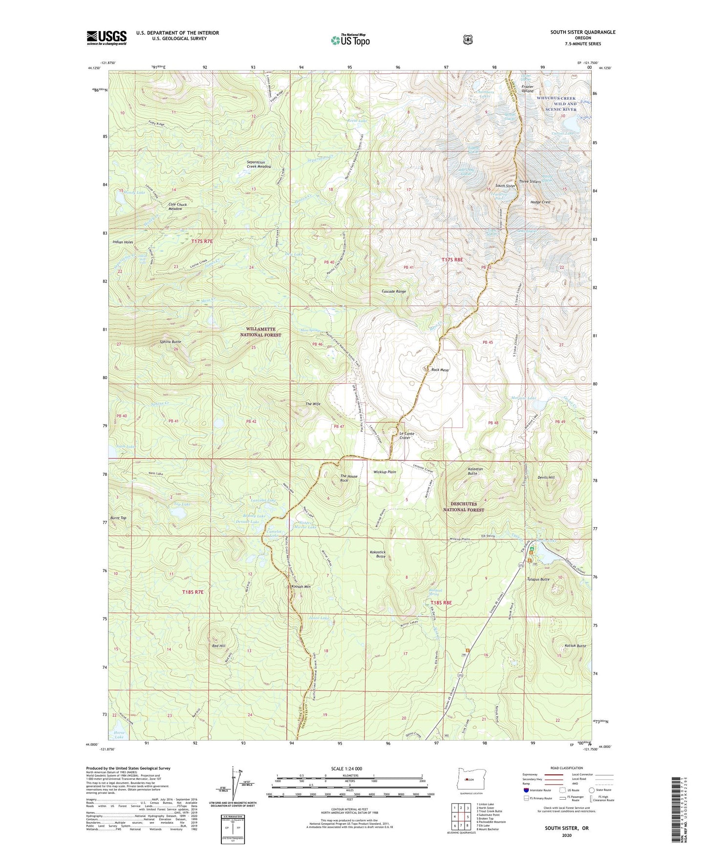
South Sister Oregon US Topo Map
Couldn't load pickup availability
Also explore the South Sister Forest Service Topo of this same quad for updated USFS data
2023 topographic map quadrangle South Sister in the state of Oregon. Scale: 1:24000. Based on the newly updated USGS 7.5' US Topo map series, this map is in the following counties: Lane, Deschutes. The map contains contour data, water features, and other items you are used to seeing on USGS maps, but also has updated roads and other features. This is the next generation of topographic maps. Printed on high-quality waterproof paper with UV fade-resistant inks.
Quads adjacent to this one:
West: Substitute Point
Northwest: Linton Lake
North: North Sister
Northeast: Trout Creek Butte
East: Broken Top
Southeast: Mount Bachelor
South: Elk Lake
Southwest: Packsaddle Mountain
This map covers the same area as the classic USGS quad with code o44121a7.
Contains the following named places: Blacktail Spring, Bounty Lake, Burnt Top, Camelot Lake, Carver Lake, Clark Glacier, Cole Chuck Meadow, Denude Lake, Devils Garden Forest Camp, Devils Hill, Devils Lake, Devils Lake Recreation Site, Dew Lake, Eugene Glacier, Frazier Upland, Hell Creek, Hinton Creek, Hodge Crest, Honey Lake, Horse Lake, Indian Hole Falls, Indian Holes, James Creek, James Creek Shelter, Junco Lake, Kaleetan Butte, Katsuk Butte, Kokostick Butte, Koosah Mountain, Lancelot Lake, Le Conte Crater, Lewis Glacier, Lost Creek Glacier, Mesa Springs, Mirror Lake Trail, Moraine Lake, Moraine Lake Trail, Prouty Glacier, Red Hill, Reese Lake, Rock Mesa, Satan Creek, Satan Creek Forest Camp, Separation Creek Meadow, Sisters Mirror Lake, Skinner Glacier, South Sister, Sphinx Butte, Talapus Butte, Teardrop Pool, The House Rock, The Wife, Three Sisters, Top Lake, Tyee Creek, Wickiup Plain, Wickiup Plain Trail