MyTopo
Sutherlin Oregon US Topo Map
Couldn't load pickup availability
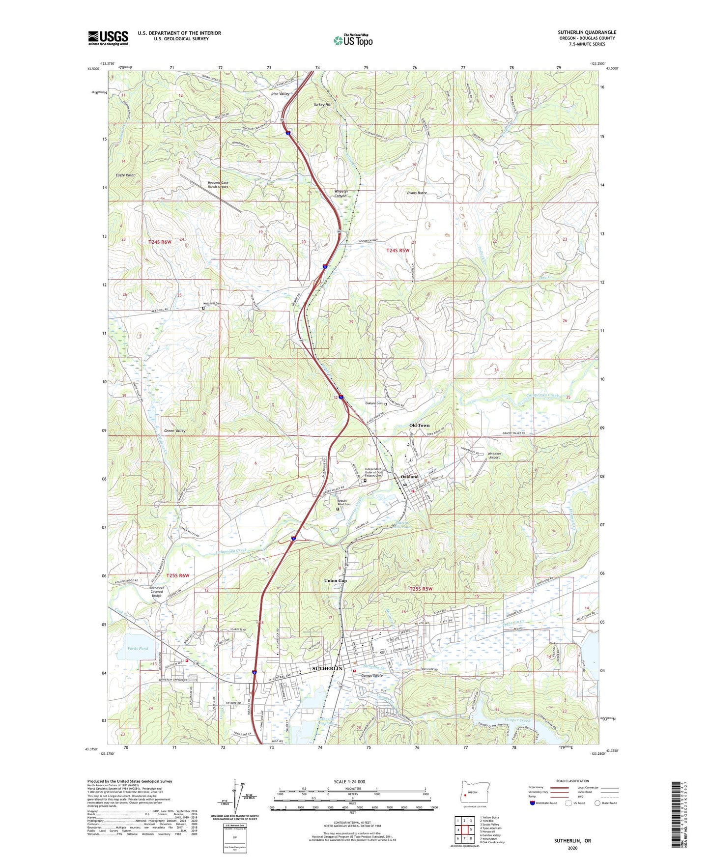
2023 topographic map quadrangle Sutherlin in the state of Oregon. Scale: 1:24000. Based on the newly updated USGS 7.5' US Topo map series, this map is in the following counties: Douglas. The map contains contour data, water features, and other items you are used to seeing on USGS maps, but also has updated roads and other features. This is the next generation of topographic maps. Printed on high-quality waterproof paper with UV fade-resistant inks.
Quads adjacent to this one:
West: Tyee Mountain
Northwest: Yellow Butte
North: Yoncalla
Northeast: Scotts Valley
East: Nonpareil
Southeast: Oak Creek Valley
South: Winchester
Southwest: Garden Valley
This map covers the same area as the classic USGS quad with code o43123d3.
Contains the following named places: Cabin Creek, Cabin Creek Safety Rest Area, Camas Swale, Church of Jesus Christ of Latterday Saints, City of Oakland, City of Sutherlin, Cook Creek, Cooper Creek Dam, Cooper Creek Reservoir, Cooper Creek Reservoir County Park Boat Ramp East, Cooper Creek Reservoir County Park Boat Ramp West, Cooper Creek Reservoir Park, Cornwall Historical Marker, Daugherty Piling Company Spur, Dimmick Creek, Eagle Point, East Sutherlin Primary School, Evans Butte, Fords Pond, Fords Pond Dam, Green Valley, Hartley Park, Heavens Gate Ranch Airport, Hog Creek, Independent Order of Odd Fellows Cemetery, Lincoln Middle School, Martin Mill Pond, Metz Hill Cemetery, Molinari Creek, North Douglas Log Ponds, Norton Creek, Oakland, Oakland Branch Library, Oakland Cemetery, Oakland Church of Christ, Oakland City Hall, Oakland Elementary School, Oakland High School, Oakland Municipal Court, Oakland Museum, Oakland Post Office, Oakland Public Works, Oakland Rural Fire Protection District, Oakland Sewage Treatment Plant, Oakland Water Treatment Plant, Old Town, Oldham Creek, Ornoname 15 Dam, Platt 1 Dam, Platt 1 Resevior Boat Ramp, Pollock Creek, Reason - Reed Cemetery, Rice Hill State Safety Rest Area, Rice Valley, Rochester Covered Bridge, Schuman Lumber Company Spur, Stearns, Stearns City Park, Sutherlin, Sutherlin C Giles Hunt Memorial Branch Library, Sutherlin City Hall, Sutherlin City Park, Sutherlin Cooper Creek Water Treatment Plant, Sutherlin Division, Sutherlin Family Church, Sutherlin Fire Department, Sutherlin Fire Department Calapooia Station, Sutherlin High School, Sutherlin Knolls Golf Course, Sutherlin Log Pond, Sutherlin Log Pond Dam, Sutherlin Middle School, Sutherlin Municipal Airport, Sutherlin Municipal Court, Sutherlin Police Department, Sutherlin Post Office, Sutherlin Public Works, Sutherlin Wastewater Treatment Plant, Turkey Hill, Union Gap, Union Gap Census Designated Place, West Sutherlin Intermediate, Wheeler Canyon, Whitaker Airport, Whitmore, Williams Creek, Youngs