MyTopo
Sweet Home Oregon US Topo Map
Couldn't load pickup availability
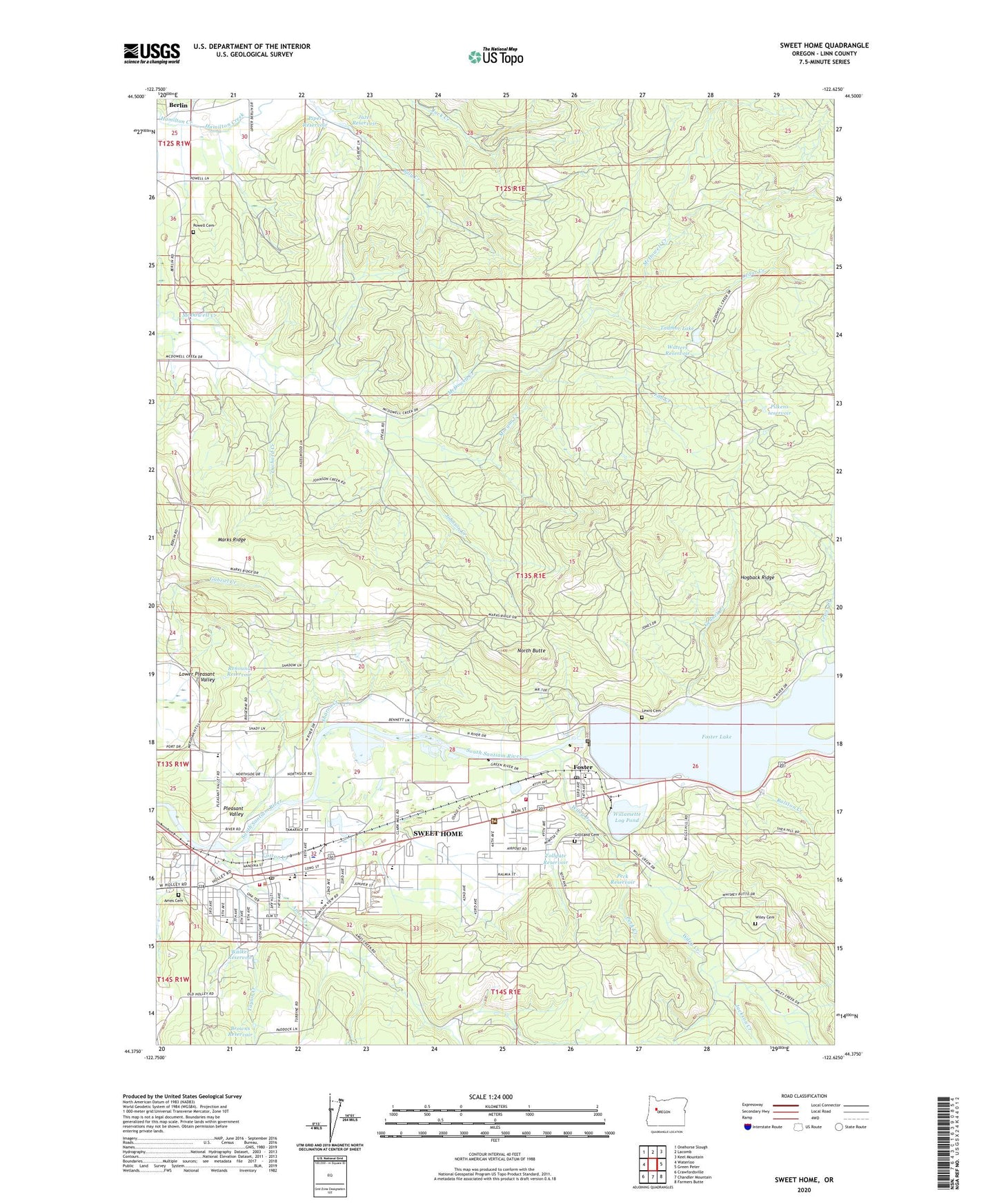
2020 topographic map quadrangle Sweet Home in the state of Oregon. Scale: 1:24000. Based on the newly updated USGS 7.5' US Topo map series, this map is in the following counties: Linn. The map contains contour data, water features, and other items you are used to seeing on USGS maps, but also has updated roads and other features. This is the next generation of topographic maps. Printed on high-quality waterproof paper with UV fade-resistant inks.
Quads adjacent to this one:
West: Waterloo
Northwest: Onehorse Slough
North: Lacomb
Northeast: Keel Mountain
East: Green Peter
Southeast: Farmers Butte
South: Chandler Mountain
Southwest: Crawfordsville
Contains the following named places: Ames Cemetery, Ames Creek, Ames Creek Boat Ramp, Andrew Wiley Park, Andrew Wiley Park Boat Ramp, Ashbrook Park, Berlin, Berlin Post Office, Berlin School, Browns Reservoir, Calkins County Park Boat Ramp, Camp Tadmor, Cedar Creek, Church of Jesus Christ of Latter Day Saints, City of Sweet Home, Cotton Creek, Crest, Edgewater RV Resort and Marina, End of Track, Fall Creek, Foster, Foster Dam, Foster Elementary School, Foster Lake, Foster Post Office, Gedney Creek, Gedney Creek County Park, Gedney Creek County Park Boat Ramp, Gilliland Cemetery, Hawthorne Elementary School, Hogback Ridge, Jackson Creek, Jazel Reservoir, Johnson Creek, KFIR-AM, KNTL-FM, Langmack Field, Langmack Hospital, Lewis Cemetery, Lewis Creek, Lewis Creek County Park Boat Access, Lewis Creek County Park Marina, Linn County Justice Court Sweet Home, Marks Ridge, McDowell Creek Camp, McDowell Creek County Park, McDowell Creek Evangelical Church Camp, McDowell Creek School, Middle Santiam River, Mint Creek, Morgan Creek, North Butte, Northside Park, Oak Heights Elementary School, Orchard Creek, Oregon Jamboree Outdoor Amphitheatre, Osage Park, Over the Top School, Peck Creek, Peck Reservoir, Pilkens reservoir, Piper Reservoir, Pleasant Valley, Pleasant Valley School, Powell Cemetery, Ralston Creek, Renound Reservoir, Sharon Creek, Strawberry Hill Park, Sweet Home, Sweet Home Charter School, Sweet Home City Hall, Sweet Home City park, Sweet Home Division, Sweet Home Evangelical Church, Sweet Home Fire and Ambulance District Station 21, Sweet Home Fire and Ambulance District Station 22, Sweet Home High School, Sweet Home Junior High School, Sweet Home Library, Sweet Home Municipal Court, Sweet Home Municipal Water Treatment Plant Facility, Sweet Home Outdoor Events Center, Sweet Home Police Department, Sweet Home Post Office, Sweet Home Public Works Department Office, Sweet Home Ranger Station, Sweet Home Wastewater Treatment Plant, Tadmor Lake, Taylor Creek, Tollgate Reservoir, Walker Reservoir, Watters Reservoir, Wiley Cemetery, Wiley Creek, Willamette Log Pond, Willamette National Lumber Company Dam, Willamette National Lumber Company Reservoir