MyTopo
Asaph Pennsylvania US Topo Map
Couldn't load pickup availability
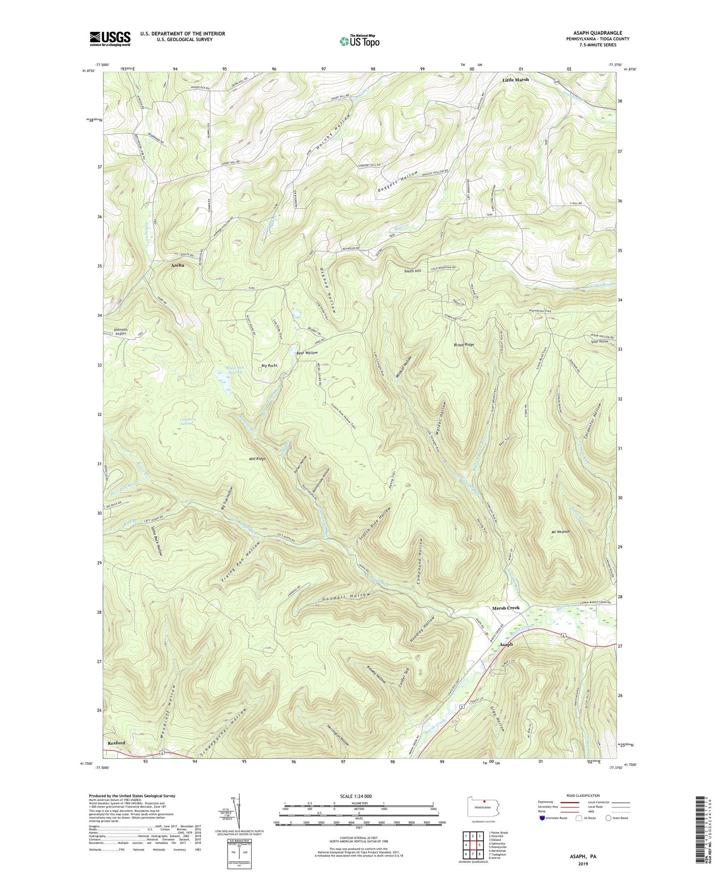
2023 topographic map quadrangle Asaph in the state of Pennsylvania. Scale: 1:24000. Based on the newly updated USGS 7.5' US Topo map series, this map is in the following counties: Tioga. The map contains contour data, water features, and other items you are used to seeing on USGS maps, but also has updated roads and other features. This is the next generation of topographic maps. Printed on high-quality waterproof paper with UV fade-resistant inks.
Quads adjacent to this one:
West: Sabinsville
Northwest: Potter Brook
North: Knoxville
Northeast: Elkland
East: Keeneyville
Southeast: Antrim
South: Tiadaghton
Southwest: Marshlands
This map covers the same area as the classic USGS quad with code o41077g4.
Contains the following named places: Ansonia Station, Asaph, Asaph Run, Asaph Run Picnic Area, Azelta, Baker Branch, Bear Wallow, Bear Wallow Branch, Bee Trail, Big Rocks, Big Tree Hollow, Black Ash Swamp, Black Ash Swamp Natural Area, Broad Ridge, Broad Ridge Trail, Broken Axe Trail, Carpenter Hollow, Compound Hollow, Confer Sag, Cranberry Swamp, Cross Trail, Daggett Hollow, Dantz Run, Darling Road Trail, Deer Lick Run, Deer Trail, Dry Hollow Trail, East Branch Canada Run, Forks Trail, Frying Pan Hollow, Gee Hollow, Goodall Fire Tower, Goodall Hollow, Gray Hollow, Harrigton Trail, Hessel Gesser Millstone, Hoadley Hollow, Horse Lane Trail, Horse Run, Jim Close Trail, Kinney Hollow, Kinney Hollow Trail, Kinney Trail, Lake Lard, Left Asaph Run, Left Frying Pan Trail, Left Straight Run, Left Strait Run Trail, Log Slide Trail, Marsh Creek, Mathers Run Trail, Middle Ridge, Middle Ridge Trail, Mount Nesmuk, Old Supply Trail, Osgood Hollow, Parker Hollow, Rattlesnake Hollow, Reese Trail, Rice Branch, Right Asaph Run, Right Straight Run, Roberts Branch, Sand Run, Schanbacher Hollow, Schanbacher Trail, Scotch Pine Hollow, Scotch Pine Hollow Trail, Sharretts Airport, South Hill, Spike Buck Hollow, Stone Road Trail, Straight Run, Township of Chatham, Township of Shippen, Walker Hollow, Water Trough Trail, Wildcat Hollow, Woodruff Hollow, Woodruff Trail