MyTopo
Washington West Pennsylvania US Topo Map
Couldn't load pickup availability
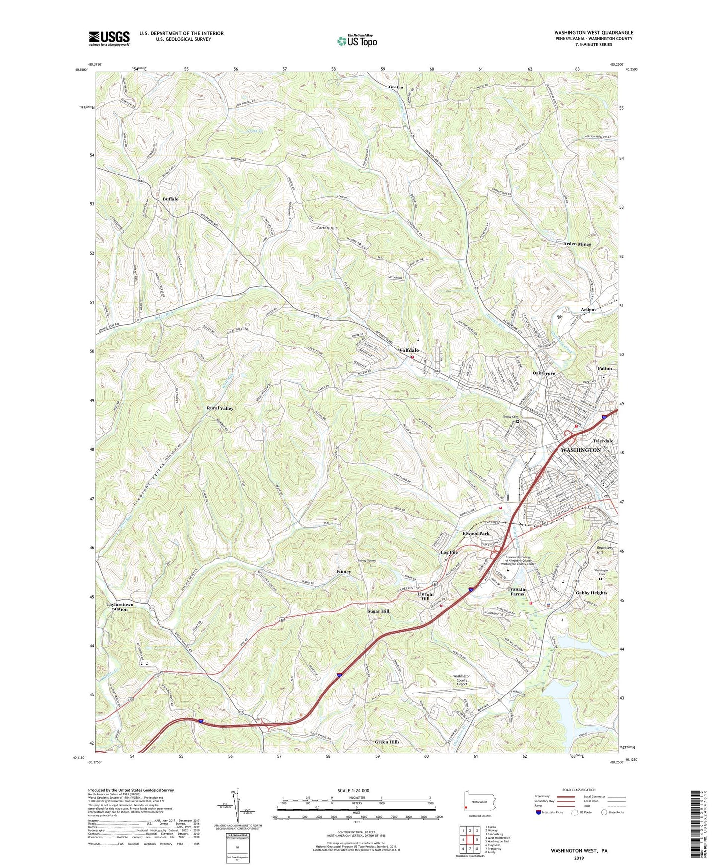
2023 topographic map quadrangle Washington West in the state of Pennsylvania. Scale: 1:24000. Based on the newly updated USGS 7.5' US Topo map series, this map is in the following counties: Washington. The map contains contour data, water features, and other items you are used to seeing on USGS maps, but also has updated roads and other features. This is the next generation of topographic maps. Printed on high-quality waterproof paper with UV fade-resistant inks.
Quads adjacent to this one:
West: West Middletown
Northwest: Avella
North: Midway
Northeast: Canonsburg
East: Washington East
Southeast: Amity
South: Prosperity
Southwest: Claysville
This map covers the same area as the classic USGS quad with code o40080b3.
Contains the following named places: Aero National Air Ambulance, Arden, Arden Fairgrounds, Arden Landfill, Arden Mines, Arden Trolley Museum, Augustatown, Bellevue, Brownson House, Buffalo, Buffalo Grange, Buffalo School, Canton Township Municipal Building, Canton Township Volunteer Fire and Rescue Company 1 Station 1, Canton Township Volunteer Fire and Rescue Engine Company 52 Station 2, Catfish Creek, Cemetery Hill, Childrens Home, Clark School, Cleland School, Coffeys Crossing, Crossroads Church, Crossroads School, Crothers, Dam Number Three, East Buffalo School, Eighth Ward School, Elwood Park, Finney, Finney Tunnel, Franklin Farms, Franklin Mall, Gabby Heights, Garrett Hill, Georges Run, Grace Avenue Church, Gretna, Gwens Montessori School, Hays Avenue School, Heavens Little Angels, Highland School, Holy Trinity Polish National Catholic Church Cemetery, Jefferson Court Center, Just Us Kids Day Care Center, Lincoln Hill, Log Pile, Log Pile School, Mel Blount Leadership Academy, Mosque Church, North Buffalo Church, North Franklin Township Municipal Building, North Franklin Township Police Department, North Franklin Township School, North Franklin Volunteer Fire Company Station 431 Substation, North Franklin Volunteer Fire Station, Number One Reservoir, Number Two Reservoir, Oak Grove, Patten Elementary School, Patton, Pleasant Valley, Rainbows End Learning Center, Reservoir Number Four, Reservoir Number Three, Rural Valley, Saint Hilary Church, Seventh Ward School, South-Bridge, Southwood School, Sugar Hill, Sunset Beach, Taylorstown Station, Township of Buffalo, Township of Canton, Township of North Franklin, Trinity Church, Tylerdale, Victory Christian Academy of the Tri State, Washington Cemetery, Washington County Airport, Washington County Day School, Washington County Home, Washington Crown Center Shopping Center, Washington Day Treatment Center, Washington Family Center, Washington Fire Station, Washington High School, Washington Post Office, Water Company Dam Number Four, Welch, White School, Wolfdale, Wolfdale Census Designated Place, Wylie Avenue School, ZIP Code: 15301