MyTopo
Coatesville Pennsylvania US Topo Map
Couldn't load pickup availability
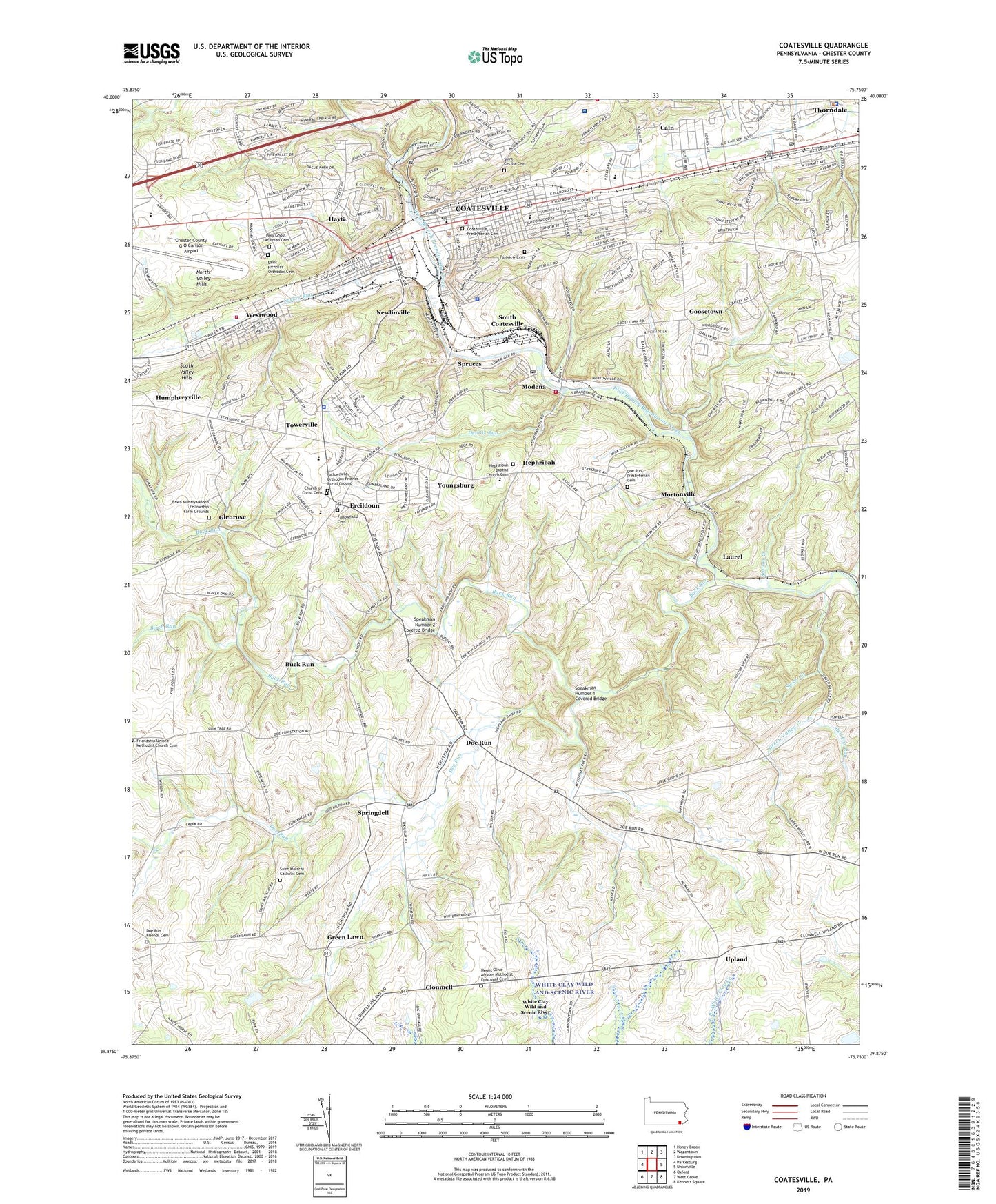
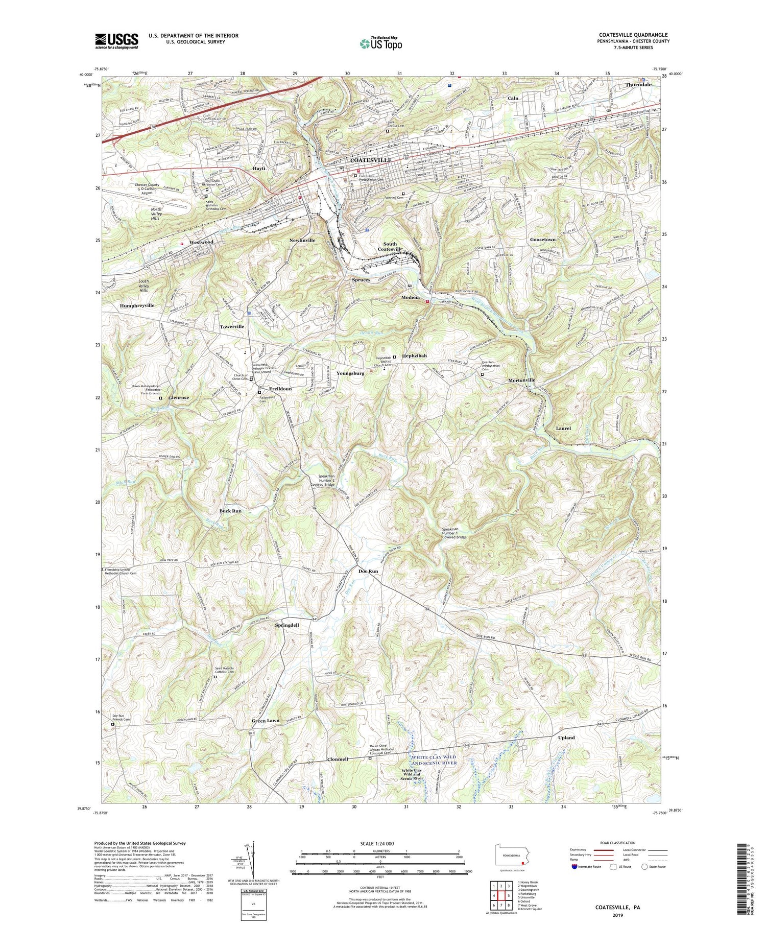
2019 topographic map quadrangle Coatesville in the state of Pennsylvania. Scale: 1:24000. Based on the newly updated USGS 7.5' US Topo map series, this map is in the following counties: Chester. The map contains contour data, water features, and other items you are used to seeing on USGS maps, but also has updated roads and other features. This is the next generation of topographic maps. Printed on high-quality waterproof paper with UV fade-resistant inks.
Quads adjacent to this one:
West: Parkesburg
Northwest: Honey Brook
North: Wagontown
Northeast: Downingtown
East: Unionville
Southeast: Kennett Square
South: West Grove
Southwest: Oxford
Contains the following named places: Bawa Muhaiyaddeen Fellowship Farm Grounds, Beaver Dam, Birch Run, Borough of Modena, Borough of South Coatesville, Buck Run, Buck Run Dam, Caln, Caln Census Designated Place, Caln Elementary School, Caln Township Building, Caln Township Heliport, Caln Township Police Department, Caln Township Police Station, Caln Township School, Carl O Benner Elementary School, Chester County Area Vocational Technical School, Chester County G O Carlson Airport, Church of Christ Cemetery, City of Coatesville, Clonmell, Coatesville, Coatesville Area Board of Education Building, Coatesville Area Senior High School, Coatesville City Hall, Coatesville Fire Department - Hose Company Station 41, Coatesville Fire Department - West End Fire Company Station 43, Coatesville Library, Coatesville Police Department, Coatesville Police Station, Coatesville Post Office, Coatesville Presbyterian Cemetery, Coatesville Veterans Affairs Medical Center, Dennis Run, Derrydown Post Office, Doe Run, Doe Run Church, Doe Run Friends Cemetery, Doe Run Presbyterian Cemetery, Doe Run Station, East Fallowfield Elementary School, East Fallowfield Township Building, East Fallowfield Township Police Department, East Fallowfield Township Police Station, Ercildoun, Fairview Cemetery, Fallowfield Cemetery, Fallowfield Orthodox Friends Burial Ground, Glenrose, Goosetown, Gordon Middle School, Green Lawn, Green Valley, Green Valley Creek, Gum Tree, Hayti, Hayti Census Designated Place, Hephzibah, Hephzibah Baptist Church Cemetery, Highland Township Building, Highland Township Police Station, Holy Ghost Ukrainian Cemetery, Kurtz Dam, Lake Kurtz, Laurel, Leonard Post Office, Lukens Steel Fire Station, Mittal Steel Fire Department, Modena, Modena Boro Hall, Modena Fire Company Station 37, Modena Post Office, Modena Station, Mortonville, Mount Olive African Methodist Episcopal Cemetery, Newlin Station, Newlinville, Preton Hall School, Rainbow Elementary School, Red Fox Run, Rock Run, Rock Run Dam, Rockby Dam, Saint Cecilia Cemetery, Saint Malachi Catholic Cemetery, Saint Malachi Church, Saint Nicholas Orthodox Cemetery, Scott High School, South Brandywine Middle School, South Coatesville, South Coatesville Boro Hall, South Coatesville Police Department, South Coatesville Police Station, Speakman Number 1 Covered Bridge, Speakman Number 2 Covered Bridge, Springdell, Spruces, Station Creek, Stoltzfus Airport, Sucker Run, Sweet Creek, Sycamore Run, Thorndale Census Designated Place, Thorndale Post Office, Towerville, Township of East Fallowfield, Township of Valley, Township of West Marlborough, Upland, Valley Station, Valley Township Building, Valley Township Police Department, Valley Township Police Station, Veterans Hospital Township Police Station, West Marlboro Township Building, Westwood, Westwood Census Designated Place, Westwood Fire Company Station 44, Youngsburg, ZIP Codes: 19320, 19358, 19372