MyTopo
Conestoga Pennsylvania US Topo Map
Couldn't load pickup availability
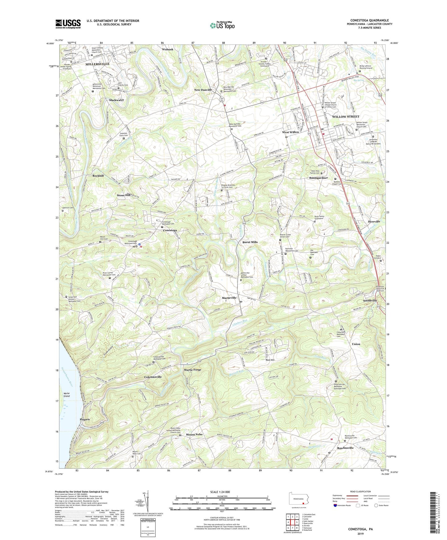
2019 topographic map quadrangle Conestoga in the state of Pennsylvania. Scale: 1:24000. Based on the newly updated USGS 7.5' US Topo map series, this map is in the following counties: Lancaster. The map contains contour data, water features, and other items you are used to seeing on USGS maps, but also has updated roads and other features. This is the next generation of topographic maps. Printed on high-quality waterproof paper with UV fade-resistant inks.
Quads adjacent to this one:
West: Safe Harbor
Northwest: Columbia East
North: Lancaster
Northeast: Leola
East: Quarryville
Southeast: Wakefield
South: Holtwood
Southwest: Airville
Contains the following named places: Ascension Lutheran Memorial Gardens, Baumgardner, Beaver Creek Amish Cemetery, Bender - Immel Family Graveyard, Big Beaver Creek, Big Spring, Boehm Church, Boehms Chapel Cemetery, Brenneman Farm, Burnt Mills, Byerland Church, Byerland Mennonite Cemetery, Clearfield Church, Clearfield Methodist Cemetery, Climbers Run, Colemanville, Colemanville Church, Colemanville Methodist Cemetery, Colemanville Post Office, Conestoga, Conestoga Ambulance, Conestoga Census Designated Place, Conestoga Methodist Cemetery, Conestoga Post Office, Conestoga Reformed Cemetery, Conestoga Volunteer Fire Company Station 53, Dietrich Cemetery, Goods Run, Grace United Methodist Church Cemetery, Green Hill Church, Green Hill United Methodist Cemetery, Grubb Hollow, Gypsy Hill Farm, Han Herr House, Hans Hess Family Cemetery, Herr Family Cemetery, Herrville, Holtwood Post Office, Honeysuckle Hill Farm, Huber Graveyard, Huber Run, Indian Run, J J Farms, Kreider - Snavely Family Graveyard, Lancaster Speedway, Little Conestoga Creek, Martic Forge, Marticville, Marticville Post Office, Marticville United Methodist Cemetery, Martock Run, Mellinger Station, Millersville, Millersville Post Office, Millersville Reformed Mennonite Cemetery, Millersville University of Pennsylvania, Minder's Nurseries, Mount Nebo, Mount Nebo Cemetery, Mount Nebo United Methodist Church Cemetery, Mount Zion Cemetery, Mylin Corners, New Danville, New Danville Church, New Danville Fire Company Station 55, New Danville Mennonite Cemetery, New Danville Mennonite School, New Danville Post Office, New Danville Reformed Mennonite Cemetery, Old Byerland Cemetery, Pequea, Pequea Brethren in Christ Cemetery, Pequea Church, Pequea Creek, Pequea Fire Company Station 56, Pequea Post Office, Petersville Post Office, Philip LeFevre Burying Ground, Pine View Dairy, Ranck Farm, Rawlinsville, Rawlinsville Fire Company Station 58, Rawlinsville Methodist Cemetery, Rawlinsville Post Office, Red Hill, River Corner Church, River Corner Mennonite Cemetery, Rockhill, Rush Family Graveyard, Silver Mine Run, Singing Maple Farm, Slackwater, Smithville, Smithville Post Office, South Bend Farm, Southern Regional Police Department, Spring Maple Farm, Springhouse Farm, State Game Lands Number 288, Stehman Farm Cemetery, Stehman Run, Stone Hill, Susquehanna Valley Emergency Medical Services Station 8, Township of Conestoga, Township of Pequea, Township of West Lampeter, Trevelyan Farm, Trout Run, Union, Union African Methodist Episcopal Cemetery, Wabank, West Willow, West Willow Fire Company Station 60, West Willow Post Office, Willow Street, Willow Street Census Designated Place, Willow Street Church, Willow Street Elementary School, Willow Street Fire Company Station 50, Willow Street Mennonite Church Cemetery, Willow Street Post Office, Willow Street United Church of Christ Cemetery, Willow Street Vocational Technical School, Willow Valley Golf Course, Willow Valley Square Shopping Center, WIXQ-FM (Millersville), ZIP Codes: 17516, 17551, 17565, 17584