MyTopo
Doylestown Pennsylvania US Topo Map
Couldn't load pickup availability
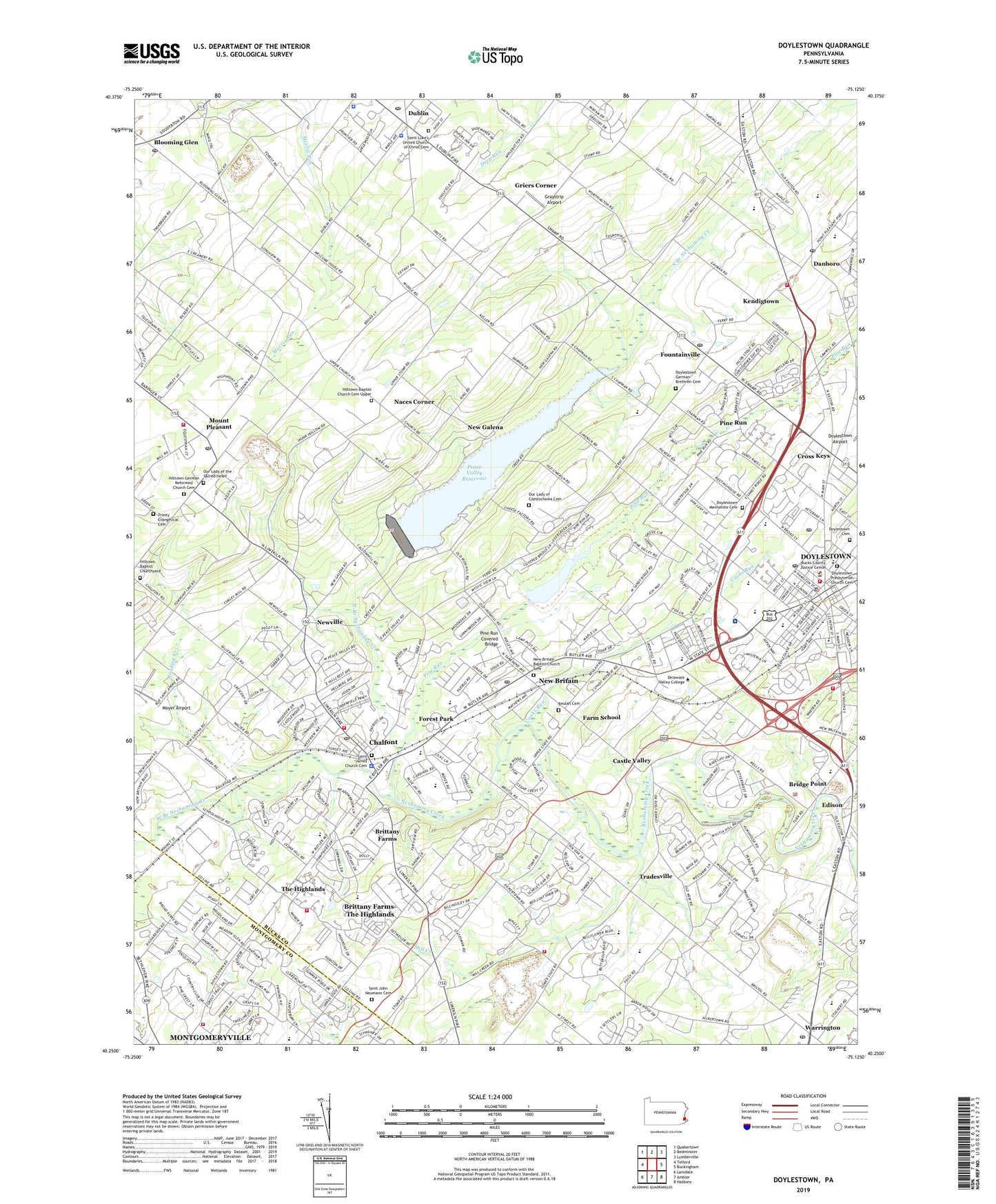
2019 topographic map quadrangle Doylestown in the state of Pennsylvania. Scale: 1:24000. Based on the newly updated USGS 7.5' US Topo map series, this map is in the following counties: Bucks, Montgomery. The map contains contour data, water features, and other items you are used to seeing on USGS maps, but also has updated roads and other features. This is the next generation of topographic maps. Printed on high-quality waterproof paper with UV fade-resistant inks.
Quads adjacent to this one:
West: Telford
Northwest: Quakertown
North: Bedminster
Northeast: Lumberville
East: Buckingham
Southeast: Hatboro
South: Ambler
Southwest: Lansdale
Contains the following named places: Andre Airport, Auriga Airport, Avallon at Moyers, Avallon at Moyers Golf Course, Barn Plaza Shopping Center, Berger School, Beulah Cemetery, Blooming Glen, Blooming Glen Post Office, Blooming Glen Quarry, Blythwood, Boglebrae Farms, Borough of Chalfont, Borough of Doylestown, Borough of Dublin, Borough of New Britain, Briarwyck, Bridge Point, Brit Village, Brittany Farms, Brittany Farms-The Highlands Census Designated Place, Brookdale, Brookshyre Woods, Buck Hills, Bucks County Administration Building, Bucks County Correctional Facility, Bucks County Courthouse, Bucks County Emergency Training Center, Bucks County Health Department, Bucks County Library Center, Bucks County Water and Sewer Authority, Bucks County Youth Center, Buttonwood Manor, Cal Brit Plaza, Carson Airport, Castle Valley, Central Bucks County Chamber of Commerce, Central Bucks High School West, Central Bucks Industrial Aero Park, Chal - Brit Regional EMS Station 134, Chalfont, Chalfont Borough Hall, Chalfont Chemical Fire Engine Company Station 74, Chalfont Elementary School, Chalfont Post Office, Chalfont Square Shopping Center, Chalfont Station, Chalfont Village Shopping Center, Chapman Shopping Center, Chesterbrook Academy, Chestnut Valley, Clayton Hill II, Colonial Trailer Park, Columbus Lake, Cooks Run, County Line Park, Covered Bridge Knoll, Cross Keys, Curley Hill Acres, Danboro, Danboro Post Office, Delaware Valley College, Delaware Valley College Station, Doyle Elementary School, Doyles Corner, Doyleston Station, Doylestown, Doylestown Acres, Doylestown Boro Post Office, Doylestown Cemetery, Doylestown German Brethren Cemetery, Doylestown Hospital, Doylestown Industrial Park, Doylestown Mennonite Cemetery, Doylestown Pointe Plaza Shopping Center, Doylestown Post Office, Doylestown Presbyterian Church Cemetery, Doylestown Shopping Center, Dublin, Dublin Post Office, Dublin Village Green, Dublin Village Shopping Center, Dyers Hill School, Edgewood Hills, Edison, Edison Post Office, Eureka Stone Quarry, Fairwood, Farm School, Farm School Post Office, Felly Tree Acres, Font Hill, Font Hill Shopping Center, Forest Park, Forest Park Dam, Foundations Behavioral Health, Fountainville, Fountainville Hills, Fountainville Post Office, Fox Hill Farms, Fretz School, Fricks, Gayman Elementary School, Gingerbread Square Shops Shopping Center, Graystrip Airport, Griers Corner, Harvest Hills, Heather Knoll, Hi View Acres, Hideaway Haven, High Point Racquet and Country Club, Highland Park, Highpoint Business Campus, Hillside Village, Hilltown, Hilltown Baptist Cemetery, Hilltown Baptist Church Cemetery Upper, Hilltown Farms, Hilltown German Reformed Church Cemetery, Hilltown Manor, Hilltown Post Office, Hunsberger School, Iron Hill School, Kendigtown, Kings Plaza, Leidytown, Lenape Junior High School, Lenape Village, Lindenfield, Link Belt Station, Little Farm Trace Park, Little Farm Trailer Park, Long Acres, Loux Corner, Meadow Brook, Meadow Lane Farms, Mercer Museum, Mercer Square Shopping Center, Michener Art Museum, Mill Creek, Mill Creek School, Mill Creek Village, Montgomery Glen, Montgomeryville Census Designated Place, Montgomeryville Golf Course, Montgomeryville Mart Shopping Center, Mount Pleasant, Moyer Airport, Naces Corner, Neshaminy Dell, Neshaminy Manor Center, New Britain, New Britain Baptist Church Cemetery, New Britain Business Park, New Britain Post Office, New Galena, Newville, North Branch Neshaminy Creek, Olde Colonial Greene, Our Lady of Czestochowa Cemetery, Our Lady of the Sacred Heart Cemetery, Oxbow Meadows, Park Ridge Estates, Patriot Place, Paul N Detwiler Elementary School, Paul N Detwiler School, Paul W Kutz Elementary School, Peace Valley Dam, Peace Valley Nature Center, Peace Valley Park, Peace Valley Reservoir, Pebble Ridge Farms, Penns Court, Philadelphia Airport, Pine Mill Estates, Pine Run, Pine Run Community, Pine Run Covered Bridge, Pine Run Dam, Pine Run Elementary School, Pine Run Valley, Pine Valley Estates, Quail Call, Railroad Creek Dam, Reading Creek, Reed Dam, Reeds Lake, Regency Wood, Rocky Meadows, Rosemore Estates, Saint Agnes Sacred Heart School, Saint James Church Cemetery, Saint John Neumann Cemetery, Saint Jude Elementary School, Saint Luke's United Church of Christ Cemetery, Sandy Ridge Acres, School of Saint Jude, Shoppes at Towne Center Shopping Center, Show Place Estates, Simon Butler Elementary School, Southwestern School, Springdale, Stoler Heights, Storybook, Tabor Home, Tamanend Middle School, The Highlands, Tohickon Middle School, Tower Hill, Tower Hill Meadows, Tower Hill Woods, Township of Doylestown, Township of New Britain, Tradesville, Trinity Evangelical Cemetery, Twin Brook Estates, Unami Middle School, Valley View, Valley View Mobile Home Park, Walsh Dam, Warrington Airport, Warrington Country Club, Warrington Post Office, Warrington Quarry, Warrington Shopping Center, WBUX-AM (Doylestown), West Branch Neshaminy Creek, Westwyk, Winners Circle, Woodridge, Woods of Sandy Ridge, Wrenfield, ZIP Codes: 18901, 18914, 18923