MyTopo
Quakertown Pennsylvania US Topo Map
Couldn't load pickup availability
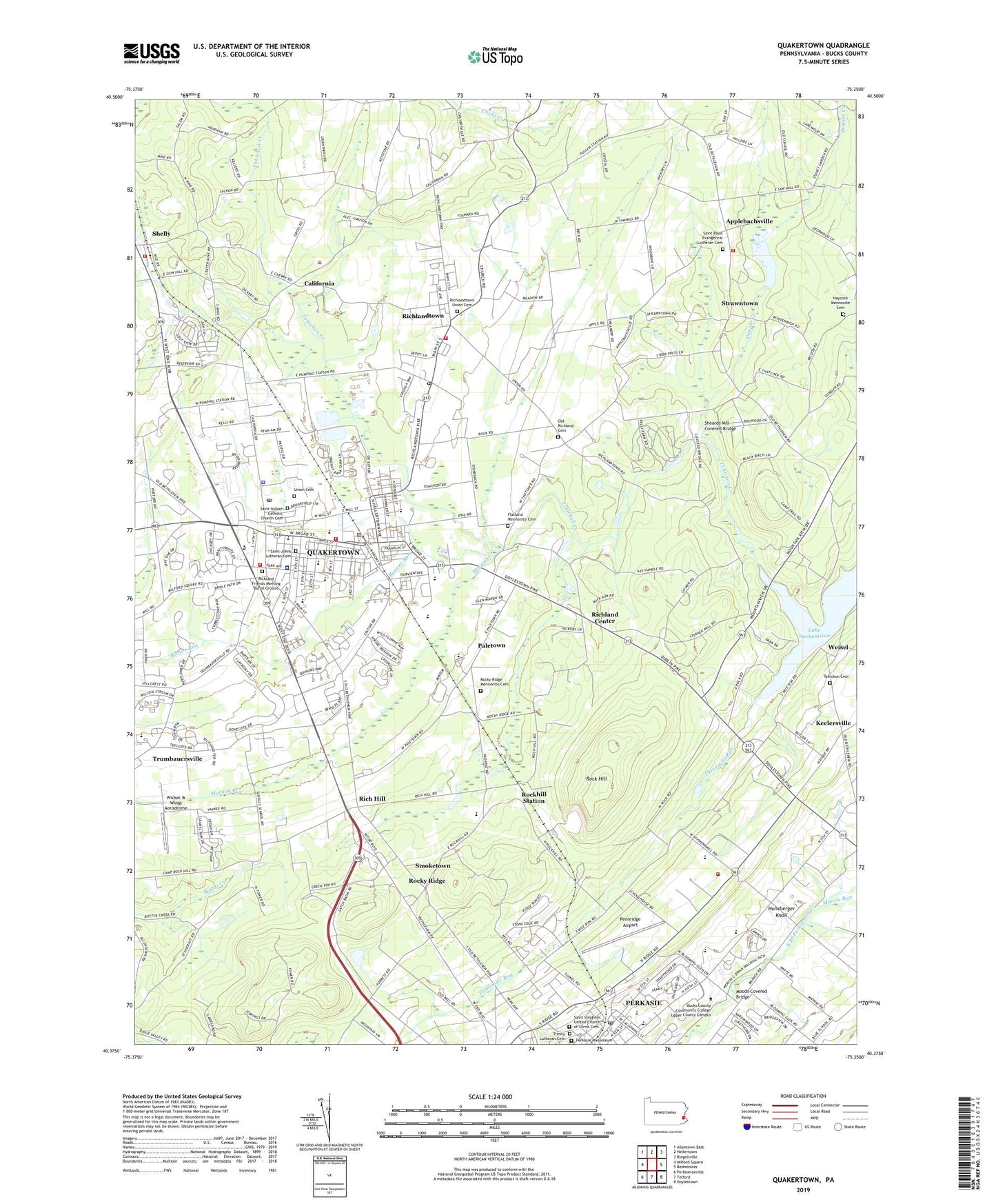
2023 topographic map quadrangle Quakertown in the state of Pennsylvania. Scale: 1:24000. Based on the newly updated USGS 7.5' US Topo map series, this map is in the following counties: Bucks. The map contains contour data, water features, and other items you are used to seeing on USGS maps, but also has updated roads and other features. This is the next generation of topographic maps. Printed on high-quality waterproof paper with UV fade-resistant inks.
Quads adjacent to this one:
West: Milford Square
Northwest: Allentown East
North: Hellertown
Northeast: Riegelsville
East: Bedminster
Southeast: Doylestown
South: Telford
Southwest: Perkiomenville
This map covers the same area as the classic USGS quad with code o40075d3.
Contains the following named places: Applebachsville, Beaver Run, Beaver Run Airport, Borough of Quakertown, Borough of Richlandtown, California, Camp Tohikanee, Cedar Grove Estates, Cedar View Estates, Country Square Shopping Center, Dimple Creek, East Rockhill Chapel, Eichner Dam, Flatland Mennonite Cemetery, Glenwood Shopping Center, Green Acres, Green Tree Estates, Gruversville, Hagersville, Haskins Dam, Haycock Church, Haycock Elementary School, Haycock Fire Company Station 63, Haycock Mennonite Cemetery, Hunsberger Knoll, Joseph S Neidig Elementary School, Keelersville, Kelly Heliport, Lake Towhee, Lake Towhee Dam, Lake Towhee Park, Louxs Corner, Lower Pennridge High School, Melody Lakes Trailer Park, Memorial Park, Moods Covered Bridge, Morgan Creek, Morris Run, Nockamixon State Park, Old Detweiler Dam, Old Richland Cemetery, Paletown, Pennridge Airport, Pennridge Central Junior High School, Pennridge District Education Center, Pennridge High School, Pennridge Industrial Park, Perkasie Elementary School, Perkasie Fire Company Station 76, Perkasie Mausoleum, Perkasie Post Office, Pullen, Q Mart Shopping Center, Quaker, Quaker Village Shopping Center, Quakertown, Quakertown Community Senior High School, Quakertown Elementary School, Quakertown Fire Company Number 1 Station 17, Quakertown Memorial Park, Quakertown Police Department, Quakertown Post Office, Quakertown Shopping Plaza, Rich Hill, Richland Center, Richland Elementary School, Richland Friends Meeting Burial Ground, Richland Mall, Richland Mead, Richland Meadows, Richland Township Fire and Rescue Station 56, Richland Township Police Department, Richlandtown, Richlandtown Elementary School, Richlandtown Fire Company Station 36, Richlandtown Post Office, Richlandtown Union Cemetery, Robert B Deibler Elementary School, Rock Hill, Rockhill Station, Rocky Ridge, Rocky Ridge Mennonite Cemetery, Rocky Valley, Saint Isadores Elementary School, Saint Isidore Catholic Church Cemetery, Saint Johns Lutheran Cemetery, Saint Lukes Hospital Quakertown, Saint Pauls Church, Saint Pauls Evangelical Lutheran Cemetery, Saint Stephens United Church of Christ Cemetery, Sheards Mill Covered Bridge, Shelly, Shelly Post Office, Smoketown, State Game Lands Number 139, Strawntown, Strayer Middle School, Tate Airport, Thatcher, Threemile Run, Tohickon Cemetery, Tohickon Dam, Tohickon Quarry, Township of East Rockhill, Township of Haycock, Township of Richland, Trainers Shopping Center, Trinity Lutheran Cemetery, Union Cemetery, Upper Pennridge High School, Village Center Shopping Center, Weisel, Weisel Youth Hoslel, West End Fire Company Station 18, West End Shopping Center, Wicker & Wings Aerodrome, ZIP Codes: 18951, 18955