MyTopo
Fort Necessity Pennsylvania US Topo Map
Couldn't load pickup availability
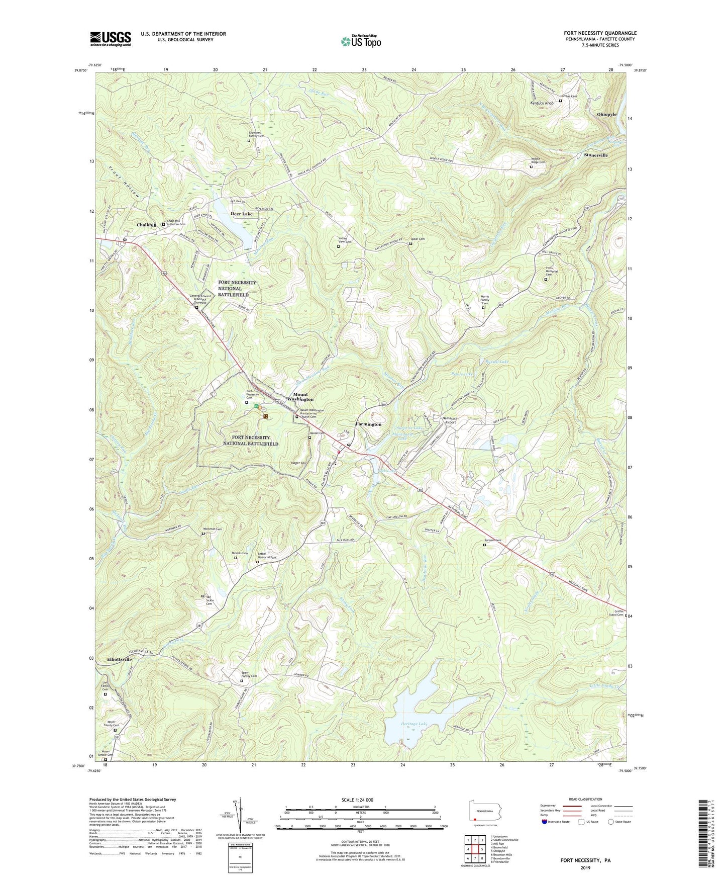
2023 topographic map quadrangle Fort Necessity in the state of Pennsylvania. Scale: 1:24000. Based on the newly updated USGS 7.5' US Topo map series, this map is in the following counties: Fayette. The map contains contour data, water features, and other items you are used to seeing on USGS maps, but also has updated roads and other features. This is the next generation of topographic maps. Printed on high-quality waterproof paper with UV fade-resistant inks.
Quads adjacent to this one:
West: Brownfield
Northwest: Uniontown
North: South Connellsville
Northeast: Mill Run
East: Ohiopyle
Southeast: Friendsville
South: Brandonville
Southwest: Bruceton Mills
This map covers the same area as the classic USGS quad with code o39079g5.
Contains the following named places: Alanconnie Lake, Beaver Creek, Bethel Chapel, Bethel Memorial Park, Bluegill Pond, Braddock Grave State Park, Braddock Run, Bryner School, Camp Riamo, Chalk Hill Lutheran Cemetery, Chalk Hill Post Office, Chalkhill, Chalkhill Census Designated Place, Chaney Run, Cromwell Family Cemetery, Cucumber Falls, Cucumber Run, Deadman Run, Deer Lake, Deer Lake Census Designated Place, Deer Lake Dam, Farmington, Farmington Census Designated Place, Farmington Post Office, Farmington Volunteer Fire Department Station 15, Fayette Emergency Medical Services Wharton, Fayette Springs, Fort Necessity Cemetery, Fort Necessity National Battlefield, Fort Necessity State Park, General Edward Braddock Gravesite, Great Gorge Trail, Great Meadow Run, Hager Airstrip, Hager Hill, Hansel Cemetery, Heritage Lake, Heritage Reservation Dam, Irwin Memorial Cemetery, Kentuck Knob, Kentuck Union Church, Lake George Dam, Lambie Cemetery, Lieb Family Cemetery, McIntire Run, Meadow Run Valley Church, Middle Ridge Cemetery, Morris Family Cemetery, Mount Washington, Mount Washington Presbyterian Church Cemetery, Moyer Family Cemetery, Moyer Umble Cemetery, Nemacolin Airport, Noahs Glade, North Branch Cucumber Run, Oak Grove School, Oak Lake, Oak Lake Dam, Peters Lake, Russell Lake, Sansom Cemetery, Sansom Chapel, Schaffer School, Scotts Run, Smiley Run, Smith School, Spaw Family Cemetery, Spaw School, Spear Cemetery, Stonerville, Stony Fork, Sunset View Cemetery, Surprise Lake, Thomas Cemetery, Township of Wharton, Trout Hollow, Van Sickle Cemetery, Wharton Elementary School, Wharton Furnace Chapel, Workman Cemetery, ZIP Codes: 15421, 15437, 15470